
|
|
|
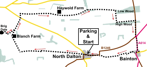
To view route as a dynamic Ordnance Survey map click here. Introduction: This walk rambles across the peaceful, rolling and relatively undiscovered chalk uplands of the Yorkshire Wolds, an area of huge fields and big skies. It is quite likely you will complete this walk as I did without seeing any other walkers. Although the walk is quite a long walk at 12 miles, is a very easy walk with virtually no ascent or descent and there are opportunities to reduce the distance via short cuts if you wish. Unlike many of my other Yorkshire Wolds walks, this route does not include some of the more dramatic dales with one small exception, namely a brief “there and back” excursion to the head of Brig Dale. You get a tiny taster of the unusual nature of these dry valleys, which will hopefully encourage you to explore more of them. Equally importantly, the banks of this valley are the best place on this walk to enjoy a picnic lunch! There is a rather unpleasant half mile stretch of road walking along the B1246 but there is no way of avoiding this other than considerably shortening the walk and missing out Bainton. The walk starts at North Dalton, an unassuming village on the B1246 between Pocklington and Driffield. There is parking at the village hall – donation appreciated. Start: Leave the village hall car park and turn right along the no through road, following the Minster way and passing the house Tithe Barn. Come to a three-way fingerpost and follow the Minster Way sign.
At the end of the first field, there is a post with multiple arrows (SE 932524). Turn left here for a short distance then turn right following another yellow arrow and walk along the left hand boundary of the field. This is a long field, which you follow in a straight line for almost a mile and a quarter, to arrive at broad concrete track (SE 912525). Turn left along this track and almost immediately right following a public footpath fingerpost. Join another concrete track at a ‘T’ junction and turn right (SE 901524), still following the Minster Way. Pass a white painted farmhouse (Blanch Farm) and just after rounding the bend, turn left following a public bridleway fingerpost (SE 897535). (This starts the brief diversion to Brig Dale and you return to this point). After a few yards, turn left again and at a ‘T’ junction of tracks, turn right, following a blue bridleway arrow, to arrive at Brig Dale. You can go further along Brig Dale to look at Lavender Dale if you wish (see my Warter Wold walk for more information/pictures regarding Lavender Dale).
Return to the farm track and turn left. Follow the farm track to the road (SE 901524) and cross straight over, following the public bridleway sign. This first short section was not shown as a public Right of Way on my (new) OS map and as the sign looked new on the date of my walk, I assume it is a recent addition, perhaps a concessionary route. After no more than three hundred yards, look out for a gap in the hedge on the right (SE 901545). This is easy to miss. Through the gap, follow the right hand field boundary, soon passing a covered reservoir on the right.
Ignore a path off to the right after about three quarters of a mile then one to the left after a further half a mile. Just after a large farm (Haywold Farm), join and follow its tarmac access track. Just as this bends right, fork off left, following a three-way fingerpost for “Public Bridleway”. You are now starting along Deepdale.
Just as you get to the end of the first field on your left, dog-leg left and immediately right to follow the bridleway along the valley bottom.
Continue along the valley bottom for about one and three quarter miles until you arrive at the corner of a wood (Low Wood SE 952547). Turn right here, following a blue bridleway arrow.
Keep straight ahead until you reach the end of the wood, then keep to the left of the hedge ahead of you. Continue to another wood and turn left to follow its left hand boundary, indicated by a public bridleway fingerpost. At the road, turn right. This is quite a busy road (B1248) and it is advisable to use the verge where possible, or be nimble to get off the road if traffic approaches! At the roundabout, cross straight over and follow its right hand side where there is a tarmac pavement. You arrive at the village of Bainton. A brown tourist sign points to a “Historic Church” and indeed, St. Andrews is a pleasant little church to visit. It originated in the 12th Century and was rebuilt in the 1350s.
Opposite the gate into the church, take the footpath between the houses and cross the main road. Walk along Back Street, curving right to meet West End where you turn left. As the road bends right and becomes Preston Lane, take the footpath on the left, through a kissing gate. Pass to the right of a small pond (not sure whether this remains in water in the summer) to a kissing gate and through this, turn right. Quickly arrive at a second kissing gate where you turn left, to follow the left hand boundary and passing a farm with an adjacent pond. Go through a farm gate, exiting on to a broad track. Turn right along this following the finger post for “Minster Way”. The route continues more or less in a straight line for just over half a mile, until you arrive at a field. To the right is the road and the speed limit sighs on the edge of North Dalton are clearly visible. Join the road and turn left into the village. It is a long village and it is about half a mile back to the village hall. If you need to buy any hiking equipment/clothing before your trip see the Hiking Store All information on this site is given in good faith and no liability is accepted in respect of any damage, loss or injury which might result from acting on it.
| | |||||||||||||||||

.jpg)
.jpg)
.jpg)
%20View%20south%20near%20stert%20of%20the%20walk.jpg)
%20Looking%20back%20towards%20North%20Dalton.jpg)
%20Looking%20along%20Brig%20Dale.jpg)
%20Farm%20on%20the%20Wolds.jpg)
%20Start%20of%20Deepdale.jpg)
%20Wide%20open%20spaces%20of%20Deepdale.jpg)
%20Shades%20of%20agriculture%20in%20Deepdale.jpg)
%20Leaving%20Deepdale.jpg)
%20St%20Andrews%20Church,%20Bainton.jpg)
%20Interior%20of%20St%20Andrews%20Church.jpg)