|
Warter
Wold
|
Starting
point and OS Grid reference:

Free
car park in Warter Village (SE 869502)
|
Ordnance
Survey Map
OS
Explorer 294 – Market Weighton and Yorkshire Wolds Central.
Buy this map from
List
of OS Maps
Commission from map sales is
used to fund the website, so keeping it free to use.
| |
Distance: 11 miles
|
Date of Walk: 17
October 2014
| |
Traffic light rating:


(For explanation see My
Walks page)
| |


For advice on .gpx files see
My
Walks page
|

Click
the PDF logo above to give a printable version of this walk without the
photos.
|
To
view route as a dynamic Ordnance Survey map click here.
Introduction:
This walk round
Warter Wold gives you views of no fewer than seven of the classic
Yorkshire Wold Dales, with their sinuous lines. It lies to the north of the
village of Warter, where the walk
starts.
Warter is a small but picturesque village
with a classic village green and Celtic cross and a pretty row of thatched
cottages. One unusual aspect of the village is that it is an “estate”
village, under the control of one owner. The church is now the Wolds
Heritage Centre. David Hockney’s famous giant painting, Bigger Trees Near
Warter, was inspired by the trees around this village (some now felled).
Warter Wold is on the western edge of the
Yorkshire Wolds with good views over the Vale of York in some places.
There is a village shop in Warter which sells
sandwiches but apart from that, there are no refreshment opportunities en
route.
To create a circular route, there is some
road walking. However, the roads are very quiet and there are wide verges.
The majority is at the end of the walk and involves the last two and a
quarter miles to Warter, along the course of a Roman road. Do not despair as
it is all gently downhill and there are lovely views along the way.
There are fingerposts for both the Minster
Way and Wolds Way, at different places, along this route.
Overall, it is an easy walk, with just a
couple of moderately steep but short ascents/descents (Millington Dale and
Sylvan Dale).
The walk starts from a large free car park
next to the school in the village of Warter. Please note that it gets very
busy at school start/finish times. To get there, take the B1246 from
Pocklington, signposted for Driffield. Warter is just over four miles from
Pocklington centre. The car park is signposted once you get to the village.
Start:
Turn left out of the car park (SE 869502) and at the road junction in the
village centre, turn right along the B1246. At the next junction (SE
873504), turn left for Huggate 3½ and Wetwang 7½ miles.
%20Thatched%20cottages%20in%20Warter.jpg)
%20Warter%20village%20green.jpg)
Walk up this road for just under a mile,
ignoring a junction on the right after a quarter of a mile. As the road
bends left, turn right off the road (SE 878513), in effect keeping straight
ahead on a track, to follow the “Public Bridleway” fingerpost.
%20Typical%20wolds%20countryside.jpg)
When the track reaches the end of the field,
turn left to follow the left hand boundary of the field beyond. In the
corner of the field you come to a three-way fingerpost. Turn right
continuing to follow the public bridleway sign.
At the end of the field, the path turns right
then immediately left to follow the line of the trees. When you get to a
corner of the trees, keep straight ahead, following the blue bridleway arrow
(SE 886524).
The path descends into Lavender Dale.
%20Lavender%20Dale.jpg)
From the bottom of the Dale, keep straight
ahead up the other side to another fingerpost and follow it left.
Keep following the obvious path along the top
of Lavender Dale then Brig Dale, following the fence on the right. As the
dale peters out, you reach a broad stony track. Turn right following the
blue arrow (SE 893535).
%20Brig%20Dale.jpg)
The track becomes almost a narrow field
between two hedges. After going
through a gateway, look out for a walkers' gate on the left, marked with a
blue arrow. Go through this to follow the line of the trees on the left.
After passing a large barn, at a three-way fingerpost, turn left on the
concrete drive following the sign for “Minster Way” (SE 898535). At the
road, turn left.
Walk along the road for about a third of a
mile and turn left through a walkers’ gate to follow the “Minster Way”
sign (SE 897545).
Follow the clear track along the right hand
boundary and after a mile and a quarter, go straight across the road (SE
877541), continuing to follow the Minster way.
%20Keasey%20Dale.jpg)
%20Well%20Dale.jpg)
After another mile and a quarter, cross
another road (SE 858537), to follow a clear track running parallel with
power lines. At the end of the field, go through a walkers’ gate by the
trees. The path drops down slightly, to follow the left flank of Nettle
Dale.
%20View%20on%20descent%20to%20Nettle%20Dale.jpg)
You meet a three-way fingerpost, not quite at
the valley bottom (SE 850540). Turn left to follow the fingerpost for
“Wolds Way Public Footpath”.
Climb the hill and you are above Millington
Dale. Go through the walkers’ gate and follow the track along the top of
Millington Dale. There is a bench with a spectacular view above this dale at
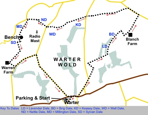
SE 846532 (see sketch map).
%20Looking%20back%20along%20Millington%20Dale.jpg)
%20View%20from%20above%20Millington%20Dale.jpg)
Shortly after the bench, at a fingerpost,
turn left to follow the “Wolds way” sign. Note that here, the OS map
shows the route as straight down the steep slope. However, the path
signposted has introduced a zig-zag to smooth out the descent. I recommend
taking it!
Descend into Sylvan Dale (SE 845530) and
follow the obvious track up the other side, following the Wolds Way
fingerpost.
At the top of the dale, go through a
walkers’ gate and turn left. Follow the path round the edge of the field,
coming out on a broad track by a farm (Warren Farm). Turn left to the road.
Walk along the road and at the ‘T’
junction, turn right to Warter.
%20Approaching%20Warter.jpg)
If you need to buy any
hiking equipment/clothing before your trip see the Hiking
Store
All information on this
site is given in good faith and no liability is accepted in respect of any
damage, loss or injury which might result from acting on it.
|


.jpg)
.jpg)
.jpg)