|
Finding Your
Way
Many people set
off on a walk relying on a route described in a book/newspaper. There are
hundreds of books on the market describing all manner of walks from easy to
difficult, linear to circular.
Many, such as
the famous ones by A W Wainwright, have exquisite drawings or photographs.
Some have a mass of information about the history of the area, flora, fauna
etc.
The problem is
that the authors may have walked the routes navigating with a map, possibly
not made notes at the time but written the description afterwards or simply
known the route so well that the directions for anyone else are lacking in
sufficient detail. Some articles/books make you wonder if the authors have ever
walked the route at all!
As an example,
you may be told to turn left at a stream. BUT, there seem to be 2 streams.
Did the author mean the first or the second? Rights and lefts have been
known to be confused.
Many books have one
thing in common, used in isolation, they will in all probability get you lost!
Being lost could
be dangerous and at best will leave you frustrated or cause arguments.
Also, if you are
caught by bad weather, you will cease to care very much about the historical
or natural facts and want efficient directions to the conclusion to the
walk. You will not want to get bogged down (maybe literally!) in the
verbiage.
The books are
great for getting the ideas but the most secure and most efficient way of
finding your way is to relate the instructions in the book to an Ordnance
Survey map. Work out in advance on the map where the route goes then
use the map for guidance in conjunction with a compass if necessary. By all
means take the book for additional information if you wish but do not
use it as your primary reference.
For even greater
certainty and if you have splashed out, a GPS receiver or GPS facility on a
smartphone can offer
spectacularly accurate wayfinding if used intelligently. However you should
still take a map and compass and know how to use them. Batteries might fail!
So let us take
this in easy stages.
One of the biggest mysteries of
walking is often perceived to be use of the compass. It is not rocket
science and is actually really simple. A full description of how to use a
compass is given in the Using
A Compass page.
The type you want consists of a
transparent baseplate on which is a transparent compass which turns. The
compass should have parallel lines across its base. A magnifying glass
is usually included. The most basic compass which fits this description will
suffice for most walking. It is not necessary to buy a Rolls Royce version.
|
Probably the world leader and
most commonly available are the
|
Silva Compasses
|
For the UK, Ordnance Survey
maps are invaluable. Buy the 1:25000 scale. The 1:50000 maps do show most footpaths but far more detail is on the 1:25000 range. More advice on this
subject is on the Ordnance
Survey Maps page. See the full range of 1:25000
maps.
People often think OS maps are
expensive but bear in mind that each one can provide a myriad of routes. If
each map gives you half a dozen walks (and they will give considerably more
if you look after them) the cost per walk is well under the cost of half a pint
of beer which you would no doubt not think twice about.
Get a map case in which to put
the map. Two reasons for this. If folded to show the right section for your
walk, once in the case, you will not be constantly folding/unfolding - which
will wear it out. The case will also protect from the rain. A simple cheap
plastic transparent case is not expensive though may crack after a time.
They also have a weak spot where a simple Velcro strip fastens. A superior
map cases is produced by Ortleib which feels like a transparent rubber type
material and with a
wrap over seal guaranteed waterproof.
Avoid the map cases which are
plastic one side and a fabric the other. These tend to let in water.
An alternative is to get plastic
laminated maps but these are much more expensive than the paper ones.
The ultimate navigational aid is
the GPS
receiver. Garmin are probably the best known manufactures. These are
relatively expensive items. They are extremely useful but by no means
essential. Certainly, do not buy one until you have done some walking and
decided you want to continue with the pastime. Some modern mobile phones
also have a GPS facility.
If you have a smart phone and
decide to use this for navigation beware. Although there are different apps
available and they can be very accurate, they can quickly run out of
battery. There are countless stories where Mountain Rescue Teams have had to
be called out to rescue people who have been relying solely on phones. Some
have not even had proper maps with them. Please always carry a map and
compass even if you are using a phone to navigate and familiarise yourself
with their use on a familiar route first.
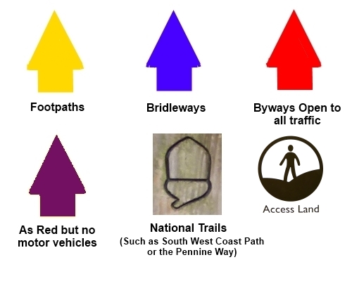
In the field, a variety of signs
help you find your way. The nationally recognised ones are below although
other colours do crop up, often a local route devised by a local authority
or organisation.
Using
Map and Compass Reading List
Visit the Happy Hiker (in
Association with Amazon) Hiking
Store to buy navigational equipment and Ordnance Survey maps.
All information on this
site is given in good faith and no liability is accepted in respect of any
damage, loss or injury which might result from acting on it.
|


.jpg)
.jpg)
.jpg)