
|
|
|
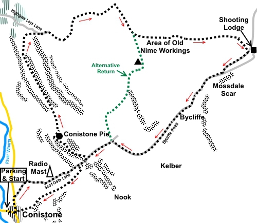
To view route as a dynamic Ordnance Survey map click here. Introduction: This walk visits some of the same points as two of my other walks, namely the Linton and Kilnsey Circular and Grassington Moor and the Lead Mines. However this particular route was selected following an extensive period of wet weather in the hopes of providing a walk relatively free from mud/bog and in that sense largely succeeded. The route visits some interesting features, not least an area of limestone pavement, the cutely named Conistone Pie, some old mine workings and Mossdale Scar. Finally, perhaps saving the best until last, the walk culminates in a descent down the gorge of Conistone Dib. Mossdale Scar is a limestone cliff and beneath this, Mossdale Beck gurgles as it disappears into caverns beneath. The caverns are rather notorious in that on 24 June 1967, a group of six cavers became trapped and five were killed, despite extensive efforts to rescue them. Their remains still lie entombed in the cave system. There is a cairn on the hill above which marks their position below. All along the route are fabulous views, although my day suffered from rather hazy vistas. The terrain is mostly easy, with a slight uphill at the start and a slightly steeper bit in the middle, which is why it earns an amber marking. At the start of Conistone Dib is a short, easy scramble but this is only four or five yards, I cannot bring myself to give it a red! Some of the walk diverts off official Rights of Way, across access land, to give you a close up view of some of old lead mine workings. The walk starts from the pretty village of Conistone, along a “No Through Road” just off the B6160 at Kilnsey, between Threshfield and Kettlewell. The best place to park is just after crossing the river bridge where the road widens a little. Space in the village itself is limited. The Tennant Arms, just down the road at Kilnsey is a handy “refreshment” point, after the walk. Start: Head along the road into the village. At the road junction, turn left, signposted for St Mary’s Church and walk along the road for about two hundred and fifty yards.
Turn right off the road at a fingerpost for “Sandy Gate 4 miles”, to walk along the broad, walled lane, which is tarmaced in parts (Scott Gate Lane) (SD 981677).
Follow the lane past the radio mast. You reach the prominent limestone outcrop of Hill Castles Scar. Follow the lane beyond the end of this, to turn left and walk along the top of the scar (SD 993683).
At the limekiln, follow the track to its left. Cross a step stile to arrive at the unmistakable outcrop of Conistone Pie. It is worth walking clockwise round this for lovely views along Wharfedale towards Kettlewell.
Having circuited Conistone Pie, head left along the long fairly straight path, which initially follows a fence line. Follow this path for about a mile. You approach a plantation. Before you get to it, take a right fork (SD 983701). This avoids the dog-leg of following the official footpath all the way to the plantation then turning right. At the top of the rise, turn right through a gate (SD 985704).
Once through the gate, follow the path as it curves left, to the brow of the first hill. Here, turn right for a short distance before curving left round some small limestone outcrops. The route was pretty obvious as it seems well used by the farmer on a quad bike, judging from the wheel marks. Arrive at a gateway but do not go through it but turn left to follow the wall, now on your right. Follow the wall to the next gateway, then bear off left to follow a faint track. It becomes a more prominent track. Follow this as it curves right, eventually following a dilapidated wall and passing evidence of old bell pits. You also pass to the left of a rocky scar (SD 995707). The dilapidated wall curves left to meet the path which passes through it. Climb the hill ahead, heading for the gate visible on the near horizon. There a few rocks by this gate which made a good lunch stop with a view. Cross
the ladder stile by this gate and turn right, to follow the path for about a
third of a mile, to arrive at a three way fingerpost (SE 001704). The finger
points straight on to Conistone and this is a way of shortening the walk
should you wish. However my route turns left at this fingerpost, leaving the
official footpaths and passing through the old mine workings. There is no easy to describe route through the workings, which follows what would at one time have been miners' paths. The best advice is to stick to the left hand side as far as you can, along the edge of the heather. Better still from the fingerpost, use a compass and follow 98° magnetic. Beyond the workings and following this line, you will discover a more obvious path at SE 0057270346. I give the precise GPS reference in case you are using a GPS receiver/mobile app. The path starts to gently descend arriving at Swarth Gill at SE 013704. Cross and follow the path beyond. You soon come to some more mining remains where there are a couple of flat, laid stones which would make a good lunch stop for 2/3. Beyond the mining remains, the track is unmistakable. Follow it to descend into Mossdale, close to the well preserved and secured (probably) former mining building and now probably a shooting lodge.
Drop down to a crossroads of broad tracks and turn right (SE 020701).
After two or three hundred yards, the main track bends left and starts to climb. However on the bend, take the right fork on a slightly less well maintained track (Bycliffe Road).
Continue to another cross roads of tracks and turn left to follow the sign for “Conistone” (SD 997687). Note this is the point you would come to if you had taken the short cut mentioned earlier. The track descends to the point on Hill Castles Scar which you passed on the outward journey. You could retrace your steps but it would be folly to miss Conistone Dib! Continue a couple of hundred yards down the broad track and turn left through a gate signposted for “Dalesway Footpath, Grassington 2½ miles”. Immediately cross a culvert via stone slabs, then turn immediately through a kissing gate, to descend Conistone Dib. Be careful for the first through yards where you have to scramble down a very short section but after that is an easy walk down into Conistone.
If you need to buy any hiking equipment/clothing before your trip see the Hiking Store All information on this site is given in good faith and no liability is accepted in respect of any damage, loss or injury which might result from acting on it.
| | |||||||||||||||||

.jpg)
.jpg)
.jpg)
%20Centre%20of%20Conistone.jpg)
%20St%20Marys%20Church,%20Conistone.jpg)
%20View%20to%20Kilnsey%20Crag.jpg)
%20Top%20of%20Conistone%20Dib.jpg)
%20Hill%20Castles%20Scar.jpg)
%20Cairn%20and%20lime%20kiln%20at%20Hill%20Castles%20Scar.jpg)
%20Limestone%20Pavement.jpg)
%20Conistone%20Pie.jpg)
%20View%20from%20Conistone%20Pie.jpg)
%20View%20to%20Great%20Whernside%20and%20Buckden%20Pike.jpg)
%20Looking%20down%20on%20Mossdale%20shooting%20hut.jpg)
%20Mossdale%20Scar.jpg)
%20Scars%20at%20Bycliffe.jpg)
%20Short%20scramble%20at%20Conistone%20Dib.jpg)
%20Gorge%20section%20of%20Coniston%20Dib%20(looking%20down).jpg)
%20Gorge%20section%20of%20Coniston%20Dib%20(Looking%20up).jpg)