|
Steeton
to Ilkley via the Doubler Stones
Starting point and OS Grid reference:

Steeton
Railway station (SE 038449)
|
Ordnance Survey Map
Explorer
297 - Lower Wharfedale & Washburn Valley
OL
21 - South Pennines.
Buy this map from
List
of OS Maps
Note: If you use OS Maps on-line, you can download this route via this
link.
| |
Distance:
7.25
miles
|
Date of Walk:
13 February 2012
| |
Ascent:
Descent:
See Walking Time Calculator
|
1095ft (334m)
1068ft (326m)
| |
Traffic
light rating: 

(For explanation see My
Walks page)
| |


For advice on .gpx files see
My Walks page
|

Click
the PDF logo above to give a printable version of this walk without the
photos.
|
To
view route as a dynamic Ordnance Survey map click here.
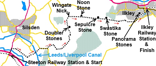
Introduction:
This is a linear walk
best done by train or bus. It traverses the western side of Rombalds
Moor from Airedale to Wharfedale with good views of both. It also takes you
past the Doubler Stones - rocks weirdly shaped by the elements, and other
well known rocky landmarks. Rombalds/Ilkley Moor is well known for its cup
and ring and other ancient rock art. Rocks are scattered all over the moors
hereabouts although finding some of them can be something of a challenge
amongst the heather and bracken. There should be no problem I respect of the
items listed here.
The directions start at Steeton and end at
Ilkley railway stations on the assumption the train is used but buses also
serve both destinations. Refreshments aplenty and toilets are available in
Ilkley.
The walk spans two maps but you are more
likely to need OL21 in terms of route finding which includes Wingate Nick.
The section on Explorer 297 as you get closer to Ilkley is very clear on the
ground and you would have to work hard to get lost!
Start:
Exit Steeton station turning right and climb the steps to Station Road.
Cross Station Road and turn right and walk to the roundabout. Cross the main
A629 to the left of the roundabout (the footpath soon runs out on the right
once you cross). This is an extremely busy road so take care.
Once across, walk along the pavement in the
direction of Silsden. Look out for a green finger post on the right after crossing the River Aire. Cross the little stone footbridge
here (SE 039453).
%20Millennium%20Way%20sign.jpg) Cross over a broad track following yellow
arrow signs for the Millennium Way. When you reach the low flood prevention
banking (levee), as the stream curves away, bear left and follow the fence
line.
Cross over a broad track following yellow
arrow signs for the Millennium Way. When you reach the low flood prevention
banking (levee), as the stream curves away, bear left and follow the fence
line.
Pass under two sets of power lines and go
through the small stone stile on the right and turn left. On approaching a
very large property (Howden House), exit on to the broad track and turn left
to the road. At the road turn left again for only 100 yards or so.
Go through a metal kissing gate by a green
public footpath sign on the right (SE 051450). This crosses a beck and takes you to the Leeds
Liverpool Canal which you cross via Holden Swing Bridge.
%20Holden%20Swing%20Bridge.jpg)
Walk through the farm complex of Howden Park
and on reaching the road turn right. Walk up the road as it climbs steadily
for 1/3 mile
and as it bends sharply right, turn off left by the green finger post
indicating public bridleway (SE 060453). There are good retrospective views
here of Airedale across Steeton and Silsden.
%20View%20along%20Airedale.jpg)
Follow the broad track and just past the
barn, fork right on the grassy track, ignoring the footpath which soon
appears on the left. Go through the gate at the top of the rise and bear
right. Keep straight ahead at the next gate, following the wall on the
right.
Go through the next gateway and immediately
turn left over a wooden stile and follow the broad track to the left. Stay
on this track, climbing gradually, going through another gate. Bear left
heading towards the ruined barn. To the left of the barn are two stone slit
stiles in line. Go through these and go right round the back of the barn. On
the near horizon ahead of you is a gateway. The route is now a little
indistinct but head slightly to the left of the line to the gate. This leads
down a little valley where a stone slab bridge crosses the stream.
Over the stream, turn right then left through
a dilapidated gateway and climb the hill directly ahead. Come to two gates,
go through the left one (or over the stile next to it) and bear right
following the line of the wall on the right.
Pass Far Ghyll Grange Farm and immediately
after crossing the stream, turn right (SE 072460) (the path may be very
faint) climbing the little hill to a gateway in the wall. Through the gate
and follow the wall on the left.
Go through gate by a massive boulder and in
the farmyard, turn right (SE
072464) and follow the concrete track to the bungalow. Climb the faint
footpath to the right of the bungalow and the clear path across the moors
soon becomes visible. However look to the right and you will see the
outermost Doubler Stone. To get the best view (as in the photo), you need to
climb up to the Doubler Stones (SE 072465).
%20Doubler%20Stones.jpg)
Return to the main footpath below the stones
and turn right (north). Stay on this path as it crosses the long Parish
Boundary wall via a stone step stile. Initials carved in a step indicate its
boundary status.
Follow the path to a large stone cairn with a
Millennium Way arrow on a post in its centre at Windgate Nick (SE 072471).
There are good views here along Wharfedale. Turn right here to follow the
clear track along the edge of the moor.
%20Wingate%20Nick.jpg)
%20View%20of%20Wharfedale.jpg)
After crossing three walls, the track passes
to the right of a huge boulder. This is the Noon Stone (SE 081471).
According to one theory, the name may (or of course may not!) indicate it
was used in ancient times for timekeeping.
Cross five more walls and look out for a
boulder on the left which looks as though it has molten folds. This is the
Sepulchre Stone (SE 091470). On its top are possible ancient “cups” but
it is difficult to tell what is natural and what might be manmade.
%20Sepulchre%20Stone.jpg)
Cross the next wall and look out for the
Anvil Rock over the wall on the left. Again, markings on its surface may or
may not be manmade (SE 093470).
%20Anvil%20Rock.jpg)
Continue to follow the wall along and very
soon you come to the Swastika Stone (SE
096470). There is no mistaking this behind its iron fencing. The carving
nearest you is a Victorian reproduction of the truly ancient one behind it
so visitors could more clearly see what the carving was. You can clearly see
the swastika shape with cups in each leg. As far as I know, no-one knows
what it means.
%20Swastika%20Stone.jpg)
%20Swastika%20Stone.jpg)
At this point, rather than remaining on the
main track, bear off slightly left on a fainter track towards the corner of
the trees. This will give you a good view of the waterfalls at Heber’s
Ghyll as you cross it on a wooden bridge (SE 099469).
Stay on the track by the wall as it passes
Panorama Reservoir and the rear of the houses. On reaching the road (Keighley
Road), turn left. At the junction turn left again then right down Queens
Road. Walk along this road as it descends and immediately after passing the
junction with Princess Road, on the left behind iron fencing are the
Panorama Stones. The carvings on these rocks could be 4-5000 years old so
not surprisingly, they are badly eroded. A placard tells you their history.
%20Faint%20Carving%20on%20Panorama%20Rock.jpg)
Follow Queens Road to its end then left down
Wells Road to the station.
If you need to buy any
hiking equipment/clothing before your trip see the Hiking
Store
All information on this
site is given in good faith and no liability is accepted in respect of any
damage, loss or injury which might result from acting on it.
|


.jpg)
.jpg)
.jpg)