|
Pool-in-Wharfedale
to Leathley
|
Starting
point and OS Grid reference:

Pool
in Wharfedale – Road parking by the garage (SE243454)
|
Ordnance
Survey Map
OS
Explorer 297 – Lower Wharfedale and Washburn Valley.
Buy this map from
List
of OS Maps
Commission from map sales is
used to fund the website, so keeping it free to use.
| |
Distance: 5.7
miles
| |
Traffic light rating:

(For explanation see My
Walks page)
| |


For advice on .gpx files see
My
Walks page
|

Click
the PDF logo above to give a printable version of this walk without the
photos.
|
To
view route as a dynamic Ordnance Survey map click here.
Introduction:
This Wharfedale walk from
Pool-in-Wharfedale is all in North Yorkshire but as the start point is just
in West Yorkshire, it is listed there. It is an easy ramble around some of
the gentle countryside of lower Wharfedale. There are attractive views here
and there, not least incorporating Almscliffe Crag, the impressive
Arthington Railway Viaduct and across and along lower Wharfedale.
Riffa Wood, through which you pass, provides
a spectacular bluebell display in season.
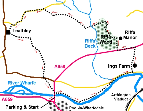
The walk starts from Pool in Wharfedale which
is on the A659 between Otley and the A61 at Harewood. In the centre of Pool,
there is a garage set in a large triangle of roads between the A659 and the
A658. The northern leg of this triangle (the left fork if you approach from
Otley) is wide with plenty of room for parking. The directions start from
there.
There are pubs in Pool to revive you at the
end of the walk! If you intend to patronise them, they may well allow you to
park in their car parks for the walk but please ask first.
Start:
Cross the river bridge heading north and take the footpath on the right
immediately you have crossed it (SE 244456), indicated by an old style metal
footpath post. Turn right again to the river and then left to follow the
path along its left hand bank.
%20Pool%20Bridge.jpg)
%20River%20Wharfe.jpg)
%20Almscliff%20Crag.jpg)
You follow the riverbank for just over ¾
mile until reaching a road (SE 257458) Turn right.
Walk along the road for 1/3
mile then turn left at Ings Farm
(SE 242461) to follow the farm drive. When you get close to the farm, do not
follow the drive as it bends right but instead, keep straight ahead to the
left of the barns. You will see a waymarked gate on the right and then turn
left.
Follow the left hand boundary of the field
and keep on this line through a small field where farm machinery is stored.
When you reach a broad track with a large barn ahead of you, turn left
through a metal gate then immediately right to follow the broad track.
When you get to the main road (the A658) turn
left (SE 263467). This is a fast busy road so take care and walk along the
footpath for about a ¼ mile until you get to the drive to Riffa Manor (SE
258466). Turn right along the drive.
When you get to the main gateway to Riffa
Manor, do not go through the gate but take the tarmac drive to the left (SE
258469). As it bends left into Riffa Wood Cottage, keep straight ahead
(effectively turning right off the drive) along a grassy track and through a
gate marked with a yellow arrow.
When the track splits at a ‘Y; junction,
turn right. At the next junction, turn right to go over a stile into a field
and follow the left boundary of the field. You only follow it for about 130
yards then go through a metal gate back into the woods (SE 256463). (Note
there looks to be a clear track through the woods which avoids the detour
via the field but I followed the official footpath route).
%20Old%20packhorse%20route%20in%20Riffa%20Wood.jpg)
Once through the metal gate there is clear
evidence of an old packhorse route in the shape of old stone flagstones.
Follow these as they descend and keep a look out for the Indian Stone on the
right. This stone is (roughly) in the
shape of an American Indian’s head. The stone is more impressive looking
back after you have passed it – well a bit! The commonly held belief is
that it was carved by an Italian prisoner of war during WWII – there was a
POW camp in the area. However why a POW would carve an Indian is a good
question and a more plausible explanation supplied to me by a local
historian is that it was carved by one Edmund Bogg and/or his bohemian
friends. Now Edmund Bogg is quite an interesting character and worth “a
Google”. He was head of the Leeds Savage Club in the early 20th century, which, in the days before
political correctness, used to dress up with feathered headdresses and hold
“pow-wows” (no pun with POW intended!) in the woods. He also wrote
extensively about rambling, especially in Wharfedale.
%20Indian%20stone.jpg)
Cross a stream at the end of the woods,
bearing right. As you climb the slope from the stream, there is a large flat
stone on the right handy for a lunch stop.
Follow the fence/wall line and turn right
through a gate at the top of the field (SE
251471).
%20View%20NE%20towards%20Almscliffe%20Crag.jpg)
%20Pleasant%20view.jpg)
On meeting another broad track, turn right.
Keep straight ahead through the next gate and
follow the track to the road where you turn left (SE 241476). Just along
here is a footpath on the left which will cut something like a mile off the
walk but it is worth sticking with the described route to see the 12th
century Church of St Oswald at Leathley and the views from the drive to
Leathley Hall.
%20Leathley%20Church.jpg)
Follow the road for half a mile to the
entrance to Leathley Hall. You turn left along the drive but before doing
so, you might like to visit St Oswald.’s Church ahead of you. This is has
a Grade I listing and dates originally from Norman times though was enlarged
in 1472 and restored in the 19th century.
Pass Leathley Hall and the remnants of the
old walled garden on the left and when the track forks, go right indicated
by a public bridleway sign (SE 238469).
After going through a couple of gates, follow
the left hand field boundary. To the left in the distance are the arches of
Arthington railway viaduct, built in 1846 and which still carries the
Leeds/Harrogate (and beyond) rail line.
%20Arthington%20Viaduct.jpg)
%20View%20towards%20Otley%20Chevin.jpg)
At the end of this field, cross a stile and
follow the right hand boundary of the next field. In the following field,
stay with the right hand boundary as it curves left . There is a not too
obvious crossing over a little stream. Over this then follow the right hand
boundary again emerging on the road (SE 241460). Turn left and after a few
yards, turn right to cross the field diagonally to the bridge. Turn right
over the bridge back to Pool.
If you need to buy any
hiking equipment/clothing before your trip see the Hiking
Store
All information on this
site is given in good faith and no liability is accepted in respect of any
damage, loss or injury which might result from acting on it.
|


.jpg)
.jpg)
.jpg)