|
Otley
to Bramhope via Eccup (return to Otley via bus)
|
Starting
point and OS Grid reference:

Otley Bus Station SE203455 - Pay and Display cp
Bridge St.
|
Ordnance
Survey Map
OS Explorer 297 Lower Wharfedale
& Washburn Valley.
Buy this map from
List
of OS Maps
Note: If you use OS Maps on-line, you can download this route via this
link.
| |
Distance: 10 miles
| |
Traffic light rating:

(For explanation see My
Walks page)
| |


For advice on .gpx files see
My
Walks page
|

Click
the PDF logo above to give a printable version of this walk without the
photos.
|
To
view route as a dynamic Ordnance Survey map click here.
Introduction: This is a useful walk after heavy snow/frosts
on short winter days when you might not want to venture too far off the
beaten track. The walk starts in Otley and finishes in Bramhope from where a
bus can be caught back to your starting point. Alternatively, buses can be
caught from Leeds to Otley then back from Bramhope to Leeds depending on
where you live. There is a very good chance of seeing red kites.
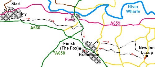
The walk begins at Otley bus station
(SE203455).
Start: Turn right out of the bus
station and walk south along Crossgate to Bondgate (the
B6451) and turn left. Follow this main road
along, round the right angle bend at the Junction pub and where the main road
turns left, you turn left along Fairfax Street which becomes Croft Street
then Lisker Drive. Continue along here until Lisker Drive does a right angle
bend to the left and at this point, there is a rough track heading south
east towards some trees. Head for these and make your way through the trees
to the route of the old railway line.
Walk along the old railway line until you see
a stile on the right (SE 220451). Climb the stile and follow the footpath to
Caley Hall Farm (SE 231449). The path passes between the farm buildings.
Remain on the footpath and at a fork, go left. You will come out on a road
(Old Pool Bank) at SE 243447. Turn right along the road and after about 150
yards take a left turn at a finger post. Follow the path through the trees
and at an old quarry, turn left.
The path shortly develops into a private road
with some very expensive looking houses. This road exits into the A658.
Cross to the other side and turn right. After 100 yards the road bends right
and here is a small road to the left by an impressive double gabled house
which you take. Follow this road. It briefly becomes a steep footpath
through trees before emerging in Starcase Lane.
Follow Staircase Lane until just before it
joins the main A660 and turn left down Hall Drive. The route along Staircase
Lane and Hall drive passes some magnificent houses. Hall Drive becomes
Creskeld Drive. Just past the junction with Hall Rise on the left is a
finger post indicating a footpath which runs through some woods alongside a
stream eventually passing a large quarry. Follow this until you reach a
road. Turn right and in about 100 yards, turn left where indicated by
another fingerpost along a broad lane.
Along this lane is the place where you are
likely to see red kites in the sky.
At SE 281437 at Bank Side, leave the main
track by a stile on the right heading south to follow the Dales Way Link.
After a third of a mile the path turns 45 degrees west. At the next farm (Brookland
Farm), the route to Bramhope turns right but if you fancy a brief detour to
the New Inn at Eccup, which you will be able to see across the fields, turn
left through a narrow stile through the stone wall. At the road, turn left
to the pub.
We pick up the route back at Brooklands Farm
at the stile in the wall. From here, walk in a westerly direction. The main
track soon becomes just a footpath. Follow it straight on, keeping Lineham
Farm on the right and ignore the broad track on the left.
At the road (SE 282429), turn briefly right
then left on to another footpath. After about 350 yards, bear right at 45
degrees across a field for about another 350 yards.
The path here is not clear and you may have to negotiate a low fence
over which you join another footpath, the Ebor Way at SE 267433. You will
see the stile.
Follow the path until it reaches Breary Lane
East (which becomes Breary Lane), a metalled cul-de-sac with yet more super
houses. Follow this road to the main A660.
You now have to decide whether to catch the
bus back to Otley or to divert to the Fox pub at Bramhope. To reach the pub,
cross the A660 and continue along Breary Lane through Bramhope to reach the
pub at the cross roads. Turning right at the pub will take you down Church
Hill back to the A660 where a right turn will quickly reveal a bus-stop.
If
you need to buy any hiking equipment/clothing before your trip see the Hiking
Store
All information on this
site is given in good faith and no liability is accepted in respect of any
damage, loss or injury which might result from acting on it.
|


.jpg)
.jpg)
.jpg)