|
Haworth
and Wadsworth Moor
Starting point and OS Grid reference: 
Lay-by
on Cemetery Road Haworth (SE 021371)
|
Ordnance Survey Map
OL21
South Pennines.
Buy this map from
List
of OS Maps
Note: If you use OS Maps on-line, you can download this route via this
link.
| |
Distance:
13.5 miles
|
Date of Walk: 19
January 2017
| |
Ascent:
Descent:
See Walking Time Calculator
|
2492ft (760m)
2516ft (767m)
| |
Traffic
light rating:

(For explanation see My
Walks page)
| |


For advice on .gpx files see
My Walks page
|

Click
the PDF logo above to give a printable version of this walk without the
photos.
|
To
view route as a dynamic Ordnance Survey map click here.
Introduction:
This
walk could include Hebden Bridge but this would add another 4 miles if you
wanted to do it. It skirts Wadsworth and Shackleton Moors above Hebden
Bridge. The walk takes you along the ancient route from Haworth to Hebden
Bridge, passing picturesque reservoirs, the pretty Crimsworth Dene and
returns via Top Withins (of Bronte fame). As indicated by my traffic lights
above there are no major ascents/descents and much of the route utilises
broad moorland tracks. The first part of the walk takes you through
Penistone Country Park.
To get
to Cemetery Road, pass through Haworth westwards towards Stanbury.
Immediately the houses finish, there is a left turn which is Cemetery Road.
The lay-by is on the right, just
past the turn for Dimples Lane. Opposite the lay-by is a finger post to
Penistone Hill which indicates the start of the walk (SE
021371).
Start: Climb
the short rise and at the top, and turn right on to the broad track
indicated by two “little green man” waymarkers with the numbers 34 and
27 (ignore the narrower track going downhill). At the next broad track, turn
right (SE 022367). Stay on this track and ignore a track to the right
signposted Top Withins.
At the
crossroad of broad tracks, carry straight on (signposted Oxenhope). When you
get to the road, turn left and almost immediately turn right opposite
Westfield Lodge signposted Bronte Falls and Top Withins (SE 018362). There
is another waymarker number 34.
Go just
past the farm and climb over the stile and turn left (SE 015359). You come
to another farm and continue straight on downhill on the broad farm track.
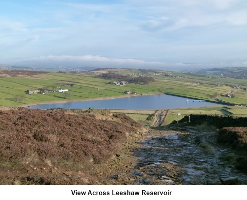
Leeshaw Reservoir is to your right. At the end of the track, go over the
cattle grid and turn right, heading towards the reservoir. Skirt round the
end of the reservoir dam and the track swings to the left heading in a south
westerly direction. Stay on this track ignoring any footpaths off to either
side.
 After 1.7 miles, the track becomes a metalled road and at the bottom of the
dip to a stream, just by the bridge, turn right on the bridleway signposted
Calder Aire Link Pennine Bridleway 4 miles (SD 995324).
After 1.7 miles, the track becomes a metalled road and at the bottom of the
dip to a stream, just by the bridge, turn right on the bridleway signposted
Calder Aire Link Pennine Bridleway 4 miles (SD 995324).
Continue
along this broad track until you reach a substantial derelict farmhouse on
the right (SD 989314). You need to go straight on but there is a track to
the right which will shorten the walk should you want to do so and cuts
about 2.5 miles off the overall walk coming out at Walshaw. This is shown on
the sketch map as the “Short Cut” in green.
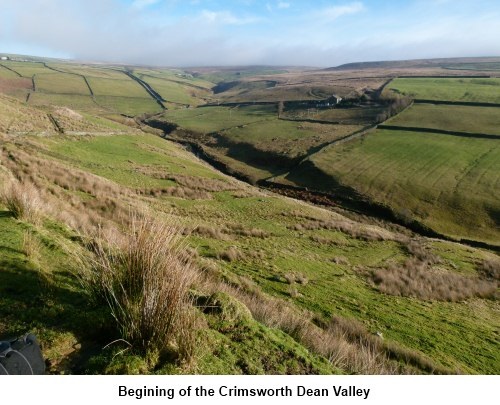
The
track now descends slightly alongside one of the prettiest sections down
Crimsworth Dene. This is particularly attractive in autumn. As the track
splits into two at a fork, bear right. There are two “Turning Ahead”
signs for vehicles (you approach them from the back) and there is a wooden
bench (SD 987299).
The
track now gently curves in a clockwise direction and passes through a group
of buildings including Rose Cottage. Below to your left is the valley in
which Hebden Bridge sits. At the next farm, the track forks and you take the
right hand fork.
At the
next junction, take the right hand fork. You come to Walshaw. Be careful
here as you want the second of the two right hand turns, the one immediately
next to Walshaw Lodge (SD 974314). If you had taken the short cut, this is
where you would emerge.
The
track bends left by an entrance to the wonderfully named “Horrodiddle”
(the OS map only spells it with one ‘R’) and at the next farm, turn
right (SD 975316) and stick to the track with a wall on your left. It then
becomes a walled lane for a short distance. At the end of the walled track,
pass through the gate or climb the stile where there is a large sign for
“Walshaw and Lancashire Moor.” Turn right here off the main track and
follow the narrow footpath on to the moors. This footpath reaches a broad
track. Cross straight over it on to another broad track and continue
straight ahead across the moor. The incline levels out and descends with
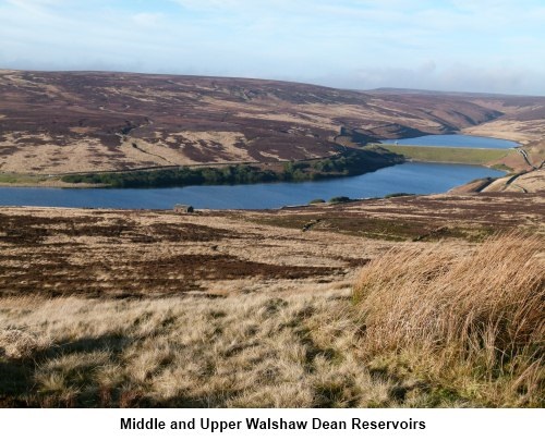
Upper, Middle and Lower Walshaw Dean Reservoirs ahead.
Pass a
small stone building on the right of the track at a bend and shortly after
this take the slightly less distinct but still broad track which branches
off to the right heading towards the middle reservoir. At the gate, go
through (SD 969337) to the land adjacent to the reservoir. Turn right and
cross the bridge heading towards the gate you can see. Ignore the sign to
the left signposted Pennine Way and signs for upper Walshaw. Follow the
signs for Top Withins. Pass through this gate and turn off to the right
rising up the moor signposted Pennine Way (SD 970339). Much of this track
has been stone paved to prevent erosion especially as you get closer to Top
Withins. In the distance to the right are numerous windmills.
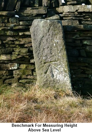
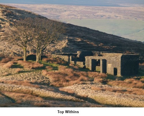
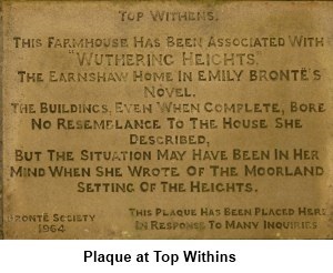
As you
crest the brow of the hill, Keighley is in the distance at about 2 o’clock
and ahead to the left are the ruins of Top Withins of Bronte fame although
as you will see when you read the stone plaque, there is no certainty this
fame is justified but it has become something of a pilgrimage for lovers of
the Bronte books.
 Just past Top Withins are the ruins of another building (SD 981353). Here a
track branches off to the right past the Bronte Waterfalls and this is
perhaps the conventional way back. It is shown on the sketch map by the
green “Alternative Route”. However unless there has been heavy rain,
these are probably worth a miss and this walk stays higher for longer to get
better views. Continue straight ahead ignoring the Bronte Waterfall sign.
Just past Top Withins are the ruins of another building (SD 981353). Here a
track branches off to the right past the Bronte Waterfalls and this is
perhaps the conventional way back. It is shown on the sketch map by the
green “Alternative Route”. However unless there has been heavy rain,
these are probably worth a miss and this walk stays higher for longer to get
better views. Continue straight ahead ignoring the Bronte Waterfall sign.
The
stone flags double up to provide a vehicle track. At the farmhouse (camp
site) turn left, signposted Stanbury and Haworth. Continue down the lane and
look out for a very high stone stile in the wall (SE 003367) as you approach
Lower Laithe Reservoir. Climb over this and go down the field and over
another stile when the ground slopes steeply away down to a pretty stream
which feeds the reservoir. Cross the footbridge, turn right and climb the
bank at the other side to another stile. Climb this and walk up the field on
the other side bearing towards its top left hand corner where there is a
ruined farmhouse. Go over the ladder stile by the ruin and turn left on a
broad track.
Go
straight across the road and you are back on Cemetery Road. The lay-by where
you started is a few hundred yards along on the left.
If
you need to buy any hiking equipment/clothing before your trip see the Hiking
Store
All information on this
site is given in good faith and no liability is accepted in respect of any
damage, loss or injury which might result from acting on it.
|


.jpg)
.jpg)
.jpg)