
|
|
|
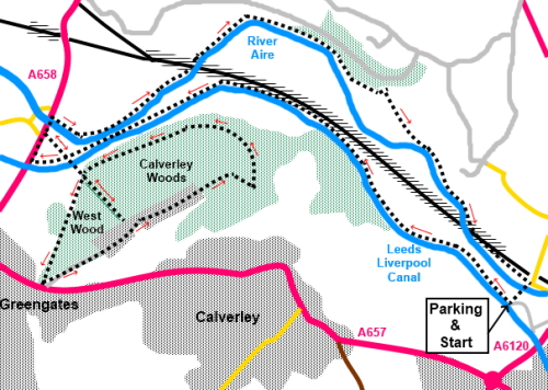
To view route as a dynamic Ordnance Survey map click here. Introduction: I do not really indulge much in urban walks, preferring the open countryside but sometimes, curiosity gets the better of me and occasionally one gets a pleasant surprise when, amidst the main roads and urbanisation, an oasis of calm arises. This is one such walk. For a large part of it, one could be miles from anywhere, although of course its location means you are not going to get it to yourself! Looking at the map one day, I noticed Calverley Wood and West Wood in West Yorkshire and by combining with paths by the Leeds Liverpool Canal and the River Aire, a circular, if convoluted route looked a possibility. Furthermore, having done a bit of research, there seemed one or two interesting features. A handy pub at the end was all I needed to give it a whirl. The walk would be very convenient for anyone living in west Leeds or east Bradford. The terrain of the walk is pretty level throughout. The only steepish uphill part is to Calverley Cutting, for which I give the amber marking, but you could omit this if you wanted. There were many wild flowers by the River Aire, including the unwanted, invasive, Himalayan Balsam, the battle against which seems well and truly lost! The Leeds Liverpool canal needs no introduction, stretching as the name suggests, 127 miles from Leeds to Liverpool and completed in 1816. This is a lock free section and you are certain to see some boats. The towpath is very popular with cyclists but unlike other experiences on towpaths, all the cyclists I saw on this day were polite and all seemed to have bells. The sharing of the path was therefore not a problem. It was a pleasant walk. The wooded area comprises two woods, Calverley Wood and West Wood. Calverley Woods really needed longer than I had this time to explore thoroughly. It contains cup marked rocks (if you can find them), the remains of an old WWII Prisoner of War (POW) camp which became a firework factory (until it blew up - again!) and old quarries. However perhaps the most dramatic feature is Calverley Cutting. This was intended to be part of a major redevelopment in the 1850s and built as a new road to replace an old packhorse route. However, it is a steep pull up to the cutting itself and this put everyone off. The sandstone cliffs are impressive and you can see drill marks where the rock was bored to place the explosives. Although West Wood is joined to Calverley Woods, it is a separate entity managed by the Woodland Trust. It once belonged to Champion House, a Victorian pile you will pass on the walk (now a care home) and contains the remnants of the old garden, well overgrown. If you have time to spare, an exploration might be fun. Sadly I did not but intend to return to concentrate on that area. The return leg follows the course of the River Aire, passing the prestigious Woodhouse Grove private school. The path passes under the impressive Woodhouse Bridge railway viaduct then a rather ugly newer metal viaduct, alongside a now disused one which has been left standing. Finally, we cross Calverley Old Bridge, over the River Aire. This was originally built in 1710 but after being damaged by floods, had to be rebuilt some 65 years later. Although it is a packhorse bridge, it is somewhat wider and more robust than many. At one time you would have had to pay a toll to cross. The icing on my cake was the Railway Inn at the end of the walk which has a pleasant garden. The walk starts from a parking area by the Leeds Liverpool Canal, just off the Leeds Ring Road (A6120) between the Horsforth Roundabout where it joins the A65 and the roundabout down the hill where it meets the A657. For safety’s sake, I strongly recommend approaching from the A657 roundabout, heading in the Horsforth direction. Take the very next turning on the left, not very far, which cuts back sharply. Park somewhere by the canal. This is not a through road so don’t go any further than the first corner. Start: From the parking (SE 222371) turn right and walk along the canal towpath for about two miles. On the way at SE 204381, you get a good view of the Woodhouse railway viaduct which you will walk beneath later on.
As you get close to the end of the canal section, pass under a green painted bridge. This carries the track up to the Calverley Cutting but you cannot access it at this point.
Shortly
after the green bridge, reach the main road (A658) at bridge number 214A.
Turn right up some concrete steps to join the pavement. Turn right, walk for
less than two hundred yards and turn right again along Parkin Lane (SE
195379). There is a public footpath fingerpost for “Pudsey Link” and
“Calverley Millennium Way”. When the lane splits, turn left over the bridge following the signs for “Pudsey Link” and “Leeds Country Way”. This is the green bridge referred to above with a good view along the canal.
Note the right turn signposted for “Calverley Millennium Way” which is your onward route, past an information board but to see Calverley Cutting, keep straight ahead up the incline. The cliffs of the cutting are impressive and particularly on the left, you can see the drill marks where holes were drilled for the explosives. Note on the right, someone has recently installed a heart shaped plaque in honour of the NHS. Ahead is the bridge which carries Clara Drive over the cutting. You will cross this later. It is not worth progressing beyond the bridge.
Return to the information board and turn left. As you walk along the obvious track, the woodland to your left is West Wood. Arrive at the end of Clara Drive, where it joins the main road (A657) and turn left along Clara Drive. Pass Champion House. This next section is something of a “millionaire’s row”, with some very prestigious houses. At the end of these, pass through a gate arrangement into Calverley Woods. After a few yards, note remains of brick buildings on the left. These are what are left of the old POW camp/firework factory.
At SE204376, not far after the brick remains, there is a small track of to the left and a few yards along here, you can look down, over the fence, into the quarry remains. Otherwise continue along the main track.
Look out for the remains of a fairly large building on the right made of concrete /breeze blocks. Shortly after this the path forks. Turn sharp left (SE 206376). Stay on the main track as it heads downhill, passing a wooden gate structure on the right hand side. At a large stone pillar with waymark arrows, the track splits. Keep left, following the yellow arrow. Off to the left somewhere on this section, is supposed to be a cup marked stone (precise reference SE 20370 37925). I made a tentative effort to find it but even with the precise grid reference and a GPS receiver, it eluded me. I think the trees were interfering with the signal; well that’s my excuse! Good luck! Stay on the track until it eventually reaches a tarmac section at a gate. Follow this back to the track up to Caverley Cutting and turn right back to the A658. At the A658, turn right and after crossing over the River Aire, turn immediately right, across the car park, following a public footpath fingerpost. Walk down to the edge of the playing field, then turn right to follow the obvious footpath. This runs along the edge of the grounds of Woodhouse Grove School then follows the river.
At SE 203383, pass under Woodhouse railway viaduct.
At
a white house, join a broad track and turn right. After passing Rawdon Water Treatment Works, the path reverts to a typical footpath. When it forks, keep right to follow the river.
At SE 218373, pass under the double railway viaducts, a rather ugly contrast to the earlier Victorian stone construction. The furthest one is now disused.
The path ends at some rough steps to a cobbled track. Turn right here (SE 222371), to cross the river via Calverley Bridge and join a lane. As this bends left, climb some steps to rejoin the canal and turn left briefly back to the car. Alternatively, stay on the lane to pass the Railway Inn, en route to the car.
If you need to buy any hiking equipment/clothing before your trip see the Hiking Store All information on this site is given in good faith and no liability is accepted in respect of any damage, loss or injury which might result from acting on it.
| | |||||||||||||||||

.jpg)
.jpg)
.jpg)
%20Leeds%20Liverpool%20canal%20at%20Calverley.jpg)
%20Canal%20distance%20marker.jpg)
%20Woodhouse%20railway%20viaduct.jpg)
%20Approaching%20the%20Calverley%20Cutting%20bridge.jpg)
%20View%20from%20Green%20Bridge.jpg)
%20Calverley%20Cutting.jpg)
%20NHS%20plaque.jpg)
%20Explosive%20drill%20marks.jpg)
%20Bridge%20over%20Calverley%20Cutting.jpg)
%20Remains%20of%20POW%20camp%20or%20fireworks%20factory.jpg)
%20Looking%20down%20into%20an%20old%20quarry.jpg)
%20Memorial%20to%20J.M.%20Breese.JPG)
%20Woodhouse%20Railway%20Viaduct.jpg)
%20A%20peaceful%20section%20of%20the%20River%20Aire.jpg)
%20Ugly%20Railway%20Viaducts.jpg)
%20Calverley%20packhorse%20bridge.jpg)