|
Burley-in-Wharfedale
Walk - Stead and Catton Wood
|
Starting
point and OS Grid reference:

The
Roundhouse, Burley-in-Wharfedale (SE 166464). Car park at rear of Queens
Hall.
|
Ordnance
Survey Map
OS Explorer 297 Lower Wharfedale & Washburn Valley.
Buy this map from
List
of OS Maps
Commission from map sales is
used to fund the website, so keeping it free to use
| |
Distance: 3.4
miles
| |
Traffic light rating:

(For explanation see My
Walks page)
| |


For advice on .gpx files see
My
Walks page
|

Click
the PDF logo above to give a printable version of this walk without the
photos.
|
To
view route as a dynamic Ordnance Survey map click here.
Introduction:
The hamlet of Stead is the furthest
point of this walk. Stead and the nearby hamlet of Burley Woodhead formed an
18C township. Indeed, Stead could have been a Roman outpost on the
Adel/Ilkley Roman road. At one time it had a hall or manor but now only the
farmstead remains. In the 16C, the manor belonged to the Knights of St John.
Stead Hall Farm and Low Stead Farm are Grade
II listed
The walk to Stead provides a very pleasant
walk with good views of Burley Moor and after passing the hamlet, there are
also fine views across the Wharfe Valley to Denton and Askwith Moors and
over Burley-in-Wharfedale itself.
There is also the opportunity to visit the
Sun Lane Nature Reserve, run by the Burley Village Wildlife Group.
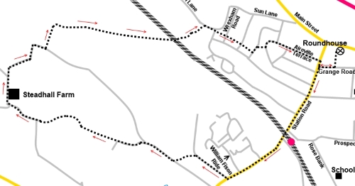
Start:
With your back to the door of the Roundhouse, turn left and walk through the
park, to Grange Road and turn right. At the junction, turn left and walk up
Station Road and under the railway bridge, where it becomes Moor Lane.
Continue up Moor Lane, passing Hag Farm Road
(on the left) and William Fison Ride (on the right). Just past the sports
field, turn right along the tarmac drive, indicated by the public footpath
fingerpost (SE 159456). The turn is directly opposite the house Oakfield.
%20Dappled%20shade%20on%20track%20off%20Moor%20Lane.jpg)
Stay on this drive passing the sports
pavilion until you reach the sign for Scalebor Park Farm, branch off left
here following the yellow footpath arrow.
On reaching a tarmac lane, turn right.
Follow the lane past the small development of
houses on the right, then branch off left, through an old green painted
metal gate, indicated by a public footpath sign – the lane past here is a
private road.
%20View%20to%20Burley%20Moor.jpg)
%20View%20Towards%20Ilkley%20Moor.jpg)
When the path forks, go through the kissing
gate and follow the left hand field boundary. Go through another kissing
gate at the end of the field and keep straight ahead.
%20Easterly%20View.jpg)
%20Bluebells%20near%20Stead.jpg)
%20Approach%20to%20Stead.jpg)
In the far right hand corner of the field, go
through a third kissing gate and keep straight ahead on the tarmac drive (SE
147459). You now stay on this track for half a mile passing through a
cluster of buildings which is Stead. The drive soon deteriorates into a
normal farm track. Past the farm, follow the track as it bends right, then
left, then right again. Turn left at a junction, where the continuation is
marked as a private road.
%20View%20to%20Otley%20Chevin.jpg)
At the next junction of tracks, turn right
(SE148565). There is a distinctive sign with yellow and blue direction
arrows and you are following the blue bridleway arrow.
%20View%20north%20to%20Denton%20Moor.jpg)
%20View%20NE%20to%20Almscliff%20Crag.jpg)
Go through the gate and follow the obvious
path to the left of the beck initially then, after going through the next
gate, cross over the beck and turn left – you will note another path
joining from the right. Burley-in-Wharfedale starts to appear below you.
%20Another%20view%20of%20Otley%20Chevin.jpg)
%20Distant%20View%20of%20Beamsley%20Beacon.jpg)
%20Approaching%20Burley-in-Wharfedale.jpg)
As you descend, you close on the corner of
Catton Wood and drop down to the railway line.
Cross this and follow the broad track beyond.
On reaching the road, if you would like to
visit the Nature Reserve, turn left but otherwise, turn right along Sun
Lane. Ignore the sharp right turn to Greenhow Park.
At the next junction, go down the little
footpath opposite, indicated with a fingerpost. You now follow this footpath
in a straight line, between the houses, crossing two roads. At the next
road, turn left then right after a few yards, again following a public
footpath fingerpost.
You come out in Midgeley Road – its road
sign is ahead of you – turn left to follow the road (Aireville Terrace).
This returns you to Station Road, where you turn right and first left on
Grange Road to return to your starting point.
If you need to buy any
hiking equipment/clothing before your trip see the Hiking
Store
All information on this
site is given in good faith and no liability is accepted in respect of any
damage, loss or injury which might result from acting on it.
|


.jpg)
.jpg)
.jpg)