|
Lothersdale
Loop
|
Starting
point and OS Grid reference:

Triangular
parking area on at start of Lothersdale (SD
961460)
|
Ordnance
Survey Map
OL
21 - South Pennines.
Buy this map from
List
of OS Maps
Note: If you use OS Maps on-line, you can download this route via this
link.
| |
Distance: 12
miles
| |
Traffic light rating:


(For explanation see My
Walks page)
| |


For advice on .gpx files see
My
Walks page
|

Click
the PDF logo above to give a printable version of this walk without the
photos.
|
To
view route as a dynamic Ordnance Survey map click here.
Introduction:
I call
this the Lothersdale Loop because it is nicely alliterative and because it
is a loop! The walk takes in Lothersdale, Pinhaw Beacon, Thornton-in-Craven,
a stretch of the Leeds Liverpool Canal and Earby. It is an easy walk through
pleasant countryside with a spell of moderate ascent out of Earby.
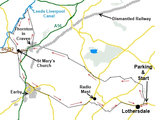
Lothersdale
is one of those places that is almost a myth. It is not somewhere you go
through on the way to anywhere else and the chances are that if you arrive
in Lothersdale, that’s where you are going. It is not that easy to find.
It is a tranquil untouched by time sort of place. According to the oracle of
Wikipedia, no house in the village is connected to mains water. This has had
the effect of limiting the amount of development that has taken place.
Unfortunately
on the day I did the walk, the weather did not live up to the BBC promise so
I must apologise for the relatively poor photos but hopefully they will whet
your appetite for what could be!
The
most straightforward way to get to Lothersdale is from the A629 Keighley to
Skipton Road. Turn off at the roundabout on to the B6172. At the A6068 Colne
Road turn right. Pass all the shops than at a mini roundabout, turn right on
to Wheatlands Lane. A “through traffic” sign further on directs you on
to Park Road. This becomes Lothersdale Road. Follow the road signs to
Lothersdale.
As you
descend into the village just after a left hand bend, look out for a large
triangular shaped lay-by with a bench. This is the best place to park.
Start:
Walk
down towards the village and just past the village hall, look out for a
finger post on the right indicating Public Footpath Pennine Way, White Hill
Lane ¾ of a mile (SD 959460).
Take this path which leads via a walled lane to a gateway and turn right signed
"Pennine Way" (the walk actually follows the Pennine Way as far as the
Leeds Liverpool Canal).
Follow
the fence line up the hill and then a wall on the left crossing a small
stile on the way. Continue following the Pennine Way signs crossing a minor
road (SD 957469) on to a concrete farm track. Where this bends left,
continue straight on through a gate.
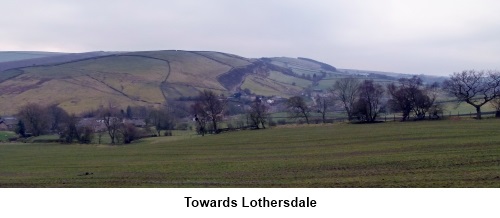
Follow
the wall on your left on to open moorland passing some grouse butts. At the
junction of paths on the moor where there is a wooden post
with a “dogs not permitted” sign, follow the main track straight
ahead to the trig point at Pinhaw Beacon (SD 944472).
From
the trig point, take one of the paths ahead (they meet a few yards on). The
track turns right at the corner of a wall still following Pennine Way signs
and leads to a road. Carry straight on down the road until the Pennine Way
bears off to the left signposted Thornton in Craven 1 ½ miles.
Over
the next ladder stile keep to the wall on the right and ignore the path
which forks off to the left and at first glance appears to be the main
track. Follow the wall down until the Pennine Way turns right over a narrow
single plank bridge then turns left to follow the wall now on your left. The
wall runs out in a large grassy field. Head slightly left following the
route of the power lines and through a kissing gate at the bottom of the
field (SD 919484) by Brown House Farm. Turn right and follow the farm lane
until it exits into a minor road. Turn left under the old railway bridge.
Climb
the lane but as you come into Thornton-in-Craven, look out for the Pennine
Way finger post on the right. The path climbs the grassy banking. Cross the
main road and go up Cam Lane.
Stay on
Cam Lane past some cottages and farm buildings. The Pennine Way turns right
(SD909495) just after a newish barn – a sign indicates that the lane ahead
(which you are leaving) is private to Langber Farm ONLY!
Follow
the footpath to the canal (SD 906504) where you turn left leaving the
Pennine Way which goes right. Walk along the canal until you reach the road
and turn left (SD 898493). About 250 yards along the road is a finger post
on the left indicating your route to Church Road ½ mile.
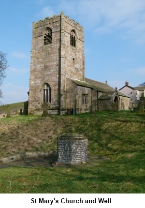
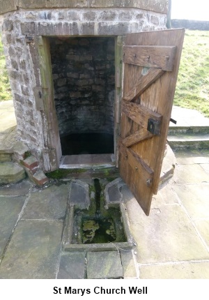
You
will soon see the tower of St Mary’s Church. Head for it and go through a
metal gate in the church grounds wall. Pass by the church tower. To the
right in the churchyard is an unusual small round stone building. This is a
covered well going back to Saxon times and is worth a look. The building
itself dates from 1764.
Leave the
church yard by the gate into the main road. Across the road, a fingerpost
indicates the continuation of the walk. Cross the field to Thornton
Hall Farm. In summer this is a country park where you can feed animals
etc. Cross the car park and follow the footpath to Earby avoiding the very
busy with lorries main road.
Exit on to
the main A56. Almost opposite is School Lane (SD 906470). Follow this down. Cross the beck and follow the road round between the
factory buildings under the overhead “corridor” between two of them and
at the mini roundabout, take the second exit, Water Street. There is now a
fairly lengthy trudge along this street and
Stoney Bank Road which it becomes.
Follow the
road which is more or less straight and quite steep for about ¾ of a mile
until it turns a sharp right hand bend. This is the tricky bit. On the bend
to the left, is a short lane leading to some cottages (SD 916464). There is
an easily missed small green footpath sign on the lamp post. Take this lane
for about 50 yards, ignore the gateway and footpath indicators ahead of you
and turn right up a steeply sloping concrete path. Although it looks as
though you are going into someone’s private property, pass in front of the
house. Just past the house, bear right and the path continues up the hill on
an enclosed track with a fence on the left and a stone wall on the right.
As the path
opens into a steep field continue up just passing the end of a wall which
juts into the field. There is a narrow stile in the stone wall straight
ahead at the top. Beyond this, the path becomes a sunken lane bearing
slightly to the right. The lane opens out into rough pasture through a gate.
Keep straight ahead keeping a stone wall to your right and ignore the ladder
stile immediately on the right.
Stay on the
obvious track heading towards the radio mast. At the top of the next field
turn right then almost immediately left. This takes you to a road where you
turn left towards the mast (SD 933459). Just before the mast, turn right
where indicated by a public footpath finger post (SD 935461).
At a very
scruffy farm, bear slightly left and go through a gap in the collapsed wall.
Go down the hill, under the power lines towards the left hand side of the
next farm. Over a stone step stile in the wall next to the farm then turn
immediately right. Diagonally across the next field there is a stile in the
wall (or gate if you prefer). Over the stile , turn right and head down
towards the road.
Across the
road turn right then immediately left through the farm gate. Follow the lane
down past the old barn. The track zig-zags through the farm before turning
right and passing an unusual barn with what looks like a church tower. Exit
into the lane and turn left.
At the next
junction by the gateway to Raygill Fisheries (SD 949461), turn left and
follow the road back into Lothersdale.
If you need to buy any hiking
equipment/clothing before your trip see the Hiking
Store
All information on this
site is given in good faith and no liability is accepted in respect of any
damage, loss or injury which might result from acting on it.
|


.jpg)
.jpg)
.jpg)