|
Lofthouse
to Scar House
Reservoir
|
Starting
point and OS Grid reference:

Village
of Lofthouse. Parking available at the Memorial Institute
(SE 102736)
|
Ordnance
Survey Map
OS
Explorer Map 298 - Nidderdale.
Buy this map from
List
of OS Maps
Note: If you use OS Maps on-line, you can download this route via this
link.
| |
Distance: 9.6
miles
| |
Traffic light rating:


(For explanation see My
Walks page)
| |


For advice on .gpx files see
My
Walks page
|

Click
the PDF logo above to give a printable version of this walk without the
photos.
|
To
view route as a dynamic Ordnance Survey map click here.
Introduction:
This walk takes you on a wonderful high level circuit around the upper
Nidderdale valley with views over Scar House Reservoir and the valley
itself. Nidderdale is just outside the Yorkshire Dales National Park but has
the accolade of being an Area of Outstanding Natural Beauty. It has moorland
vistas and is a lush green valley. The walk starts in the village of
Lofthouse. Parking is a bit limited but there is the Memorial
Institute with a car park you can use if no events are being held. If all
else fails, there is a car park on the edge of the village of Middlesmoor
through which the walk passes so you could start from there as this is a
circular walk.
If the weather turned unpleasant and you
wanted a lower level walk back from Scar House reservoir, there is the
access road to the reservoir indicated on the sketch map by green arrows.
To get to Lofthouse, heading west through
Pateley Bridge on the B6265, turn right after crossing the river bridge,
signposted for Ramsgill, Lofthouse and Middlesmoor. Continue along this road
past the expanse of Gouthwaite Reservoir and Ramsgill until you reach a
right turn signposted with a small road sign for Masham 10 miles. It is easy
to miss this turn but some blue warning signs saying Unsuitable for Goods
Vehicles and Buses indicate it.
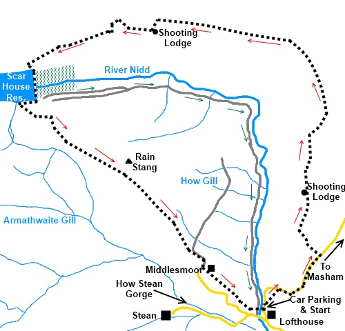
Start:
From the Lofthouse Memorial Institute car park (SE 102736), turn right and
walk through the village. Just beyond the village look out for a public
footpath fingerpost on the right. Take this faint path which just cuts off a
loop in the road. Follow the right hand fence line.
%20Nidderdale%20and%20Gouthwaite%20Reservoir.jpg)
%20Middlesmoor.jpg)
On reaching the road, turn right and walk up
the road. This is the hardest part of the walk which seems to go on for
ever. Continue up the road for about half a mile and look out for a gate on
the left hand side with a public bridleway sign
(SE 110744). Take this track and follow it
straight ahead through gaps in two walls and at a ‘T’ junction of tracks
overlooking the valley, turn right (SE 106747). You soon pass turreted
shooting lodge.
%20Looking%20down%20into%20upper%20nidderdale.jpg)
%20Shooting%20Lodge.jpg)
The track reaches a gateway through which is
a broad track. Turn left and
stay on this broad track round the valley. When it divides after going
through a gate, keep to the higher level track. When it divides again, take
the left hand arm continuing along the side of the valley.
At the next junction take the left lesser
distinct track (SE 085779). You will see a ladder stile over the wall
although do not go over this. Stay on this track until you get to a somewhat
dilapidated flat roofed shooting lodge (SE 085777). It is usually open with
rough tables and chairs and although not luxurious, it makes a useful spot
for lunch out of the wind/rain. Please leave it as you find it and ensure
the door is closed.
As you approach this shooting lodge, the
route of the walk turns right through the gate. Stay on the main track as it
descends into a small valley then up the other side. On reaching the wall,
follow its right hand side and turn right by a post in the direction of the
blue arrow with the curlew bird motif.
Ignore the next right turn and continue
straight ahead past the copse of trees.
%20Scar%20House%20Reservoir.jpg)
As you reach the area above the reservoir
dam, the track goes through a gate (SE 066772) then curves left and wends
its way down to the dam. Cross the dam and turn right along the tarmac road.
As you reach a gateway across the road, take the broad track climbing to the
left (SE 064766).
%20Looking%20back%20down%20nidderdale%20from%20scar%20house%20reservoir.jpg)
%20Spillwat%20at%20Scar%20House%20reservoir.jpg)
Stay on this main track ignoring any turns
off and it eventually leads you into the village of Middlesmoor. After
passing the Crown Hotel, go round the corner and take the cobbled lane on
the left (SE 092742). This takes you to the church. Turn right through the
narrow stone stile and along the flagged path. Through the stile at the
other end and the path drops down the field in front of the church, towards
another narrow stone stile at the bottom of the field then follows the line
of the wall towards Lofthouse.
At the farm, the route, marked with yellow
arrows, goes through the farmyard and through a metal gate at the other side
then follows the line of the stream downhill. Go through a stile at the
bottom right hand corner of the field and follow the line of the wall ahead.
As you approach a stone barn, go through the
small gated narrow stile in the wall on the right and follow the path down
to the road. At the road, via one kissing gate, there is another immediately
on the left which will take you to Lofthouse.
Cross the lane by the fire station, go
straight ahead over the footbridge across the River Nidd. The path comes out
next to Fountain Cottage and the War Memorial. Turn right and the car park
is immediately on the left.
%20River%20Nidd%20near%20Lofthouse.jpg)
If you need to buy any
hiking equipment/clothing before your trip see the Hiking
Store
All information on this
site is given in good faith and no liability is accepted in respect of any
damage, loss or injury which might result from acting on it.
|


.jpg)
.jpg)
.jpg)