|
Helmsley
Walk (Circular)
|
Starting
point and OS Grid reference:

Helmsley
– Pay and display car park on Cleveland Way (SE 610838)
|
Ordnance
Survey Map
OL26
North
York Moors – Western Area.
Buy this map from
List
of OS Maps
Note: If you use OS Maps on-line, you can download this route via this
link.
| |
Distance: 12.3 miles
| |
Traffic light rating:

(For explanation see My
Walks page)
| |


For advice on .gpx files see
My
Walks page
|

Click
the PDF logo above to give a printable version of this walk without the
photos.
|
To
view route as a dynamic Ordnance Survey map click here.
Introduction:
This walk from Helmsley explores
Ryedale and the high plateau of Rievaulx Moor before dropping down Ash Dale
back to Helmsley. There is some road walking along quiet lanes and some
areas which can be muddy after rain so gaiters are recommended.
Helmsley is an attractive market town on the
A170 Thirsk to Scarborough road. It has a ruined castle and a famous walled
garden. Not far away is Rievaulx Abbey and indeed, there is the option to
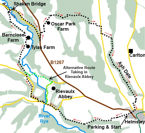
divert from this walk via the Abbey should you wish to visit it – see
sketch map.
There are various places to park in Helmsley
but it can get congested and most will probably use the pay and display car
park on Cleveland Way (off Church Street) which is where this walk begins.
The walk starts off using the Cleveland Way
long distance footpath and Ash Dale is part of the Tabular Hills walk,
another long distance footpath which starts at Scalby Mills near Scarborough
and ends at Helmsley.
There are no refreshment opportunities en
route, though plenty in Helmsley at the end.
Start:
From the car park (SE 610838), return to Cleveland Way and turn left. You
are now actually on the Cleveland Way footpath and its markers will guide
you to Ryedale. You will see a fingerpost indicating Rievaulx 2¼
miles.
When the path forks, the left hand leg
signposted to Helmsley Walled Garden, keep straight ahead and also at a
subsequent crossroads of tracks. Keep following the Cleveland Way signs
through the trees until you reach a road and turn left (SE 580841).
%20Helmsley%20Castle.jpg)
%20View%20Over%20Rye%20Dale.jpg)
%20Rievaulx%20Abbey.jpg)
As you reach the bridge over the River Rye
(SE 575843), there is the option to turn right to visit Rievaulx Abbey. You
could then continue past the abbey and rejoin this walk (see sketch map).
Otherwise, continue along the road and at the next junction, turn right for
“Cold Kirby 4 miles and Old Byland 2 miles”, crossing the bridge at
Ashberry Farm (SE 571845), at which point you leave the
Cleveland Way.
%20Ashberry%20Farm.jpg)
You can either stay on the road or, after
about 1/3 mile, there is the option to turn off left
on to a footpath across the fields. You need to follow it to return to the
road further on and it does not actually save you anything. It is a matter
of preference. Either turn left on reaching the road again (or if remaining
on the road), continue until you see the signs on the right for Barnclose
Farm and Tylas Farm and turn off here (SE 566855).
Follow the tarmac track downhill until it
joins another track. Turn left, passing a public bridleway sign.
On joining another broad track, turn right,
ignoring the footpath and yellow marker straight ahead.
At Tylas Farm, continue to follow the main
track as it goes left and then at the fork go right to continue to Barnclose
Farm.
At Barnclose Farm, go through the yard and
through a gate at the far side where you turn sharp right. The path stays
parallel with the valley.
%20View%20NE%20over%20Ryedale.jpg)
Keep straight ahead for 2/300 yards then bear
left towards the trees. There is a stile and yellow footpath markers in the
corner of the field by the trees but these are not easy to see until you are
closer to them. Cross the stile and keep straight ahead.
At the next corner of the field cross the
stile and go right to continue to follow the line of the trees. Ignore a
major looking track going off left through the trees. On the horizon in the
distance to the right you can see the Bilsdale transmitter mast.
%20View%20NE%20over%20Ryedale.jpg)
Join a broad track and turn right (SE
559878). Just before Shaken Bridge Farm bear right off the broad track on a
footpath diversion following the fingerpost for Shaken Bridge and after a
short descent, go left through a walkers’ gate. At the drive to Shaken
Bridge Farm, turn right.
At the road, turn right and walk along it for
just over 1 mile until you reach the B1257 at SE 572870. Turn left and walk
along the broad verge for no more than ¼ mile before turning right to Oscar
Park Farm.
Go through the farm and straight ahead for a
short distance then head right descending a little valley and up the other
side. Head for the gate in the top right hand corner of the field and after
going through it, follow the right hand fence.
You now enter the plantation (SE 579881). As
a managed woodland, reliable permanent directions are difficult, as logging
tracks sometimes change, so bear this in mind but in relation to the day I
did the walk, go into the trees, ignoring the track immediately on the right
and follow the main track as it curves gently right. Ignore a track on the
left.
At a ‘T’ junction of tracks, go left and
on meeting another broad track, turn right. Keep straight ahead, ignoring
another track on the right you come to almost immediately.
You will soon see your route off the main
track to the left, marked by a yellow footpath arrow on a post. Do not miss
this otherwise things get very confusing and very muddy!
Follow the footpath through the trees,
ignoring any logging tracks which cross your path. Eventually, it drops
steeply down to a stream (SE 591880) and up steps at the other side. Follow
the path through the trees and after crossing a broad forestry track, there
is a walkers’ gate where you turn left following the yellow arrow and
leave the trees.
At the next stile, cross and turn right again
following the yellow arrow. You reach the road (SE 598876) which runs up to
Baxton Farm and turn right for 3/400 yards. Turn left off the road at a
public footpath fingerpost.
Descend into Ashdale, a reasonably open dale
lined by trees and with a broad track. At a three-way fingerpost by a bench,
turn right for “Helmsley 2 miles”.
%20Ash%20Dale.jpg)
After about 1½ miles, as the trees on the
right peter out, turn right
where a three-way fingerpost indicates “Helmsley ½ mile”. Helmsley is
now visible.
Follow the yellow arrows as they zig-zag the
path around the edge of the fields, coming out in Warwick Place. At the road
junction, turn right and follow Canons Garth Lane. Turn right at the next
road junction by All Saints Church then first left on to Cleveland Way where
you started.
If you need to buy any
hiking equipment/clothing before your trip see the Hiking
Store
All information on this
site is given in good faith and no liability is accepted in respect of any
damage, loss or injury which might result from acting on it.
|


.jpg)
.jpg)
.jpg)