|
Goathland
to Grosmont
|
Starting
point and OS Grid reference:

Car
park in Goathland (NZ 933013)
|
Ordnance
Survey Map
OL27
North York Moors – Eastern Area.
Buy this map from
List
of OS Maps
Note: If you use OS Maps on-line, you can download this route via this link.
| |
Distance: 7.9
miles
| |
Traffic light rating:

(For explanation see My
Walks page)
| |


For advice on .gpx files see
My
Walks page
|

Click
the PDF logo above to give a printable version of this walk without the
photos.
|
To
view route as a dynamic Ordnance Survey map click here.
Introduction:
This is an easy 7.9 mile walk but allow plenty of time because there are
several distractions. It incorporates Mallyan Spout and Thomason Foss
waterfalls, the picturesque Beck Hole with its almost unreasonably quaint
Birch Hall Inn and the North Yorkshire Moors railway with its steam
engines. The first part of the walk follows the walk follows the track bed
of the original route of the Whitby to Pickering
Railway built by George Stephenson in 1836.
The walk starts in the
pretty moorland village of Goathland made famous by the TV series Heartbeat.
It could be done as a “half walk” by walking one way only
to Grosmont and catching a steam train back (or the other way round).
Equally, Goathland can be reached by using this service from Whitby or
Pickering or any of the intervening stations – see the NY
Moors Railway website.
By road, the main route to
Goathland is by turning west off the A169 between Pickering and Whitby.
There is a modestly priced car park in Goathland (opposite the parade of
shops) from where the walk starts. Refreshments are available in Goathland,
Grosmont and at the Birch Hall Inn. There are various benches en route for a
picnic.
Please note that although
GPS routes are provided, much of the satellite reception is affected by
overhanging trees and cliffs in places and may unreliable.
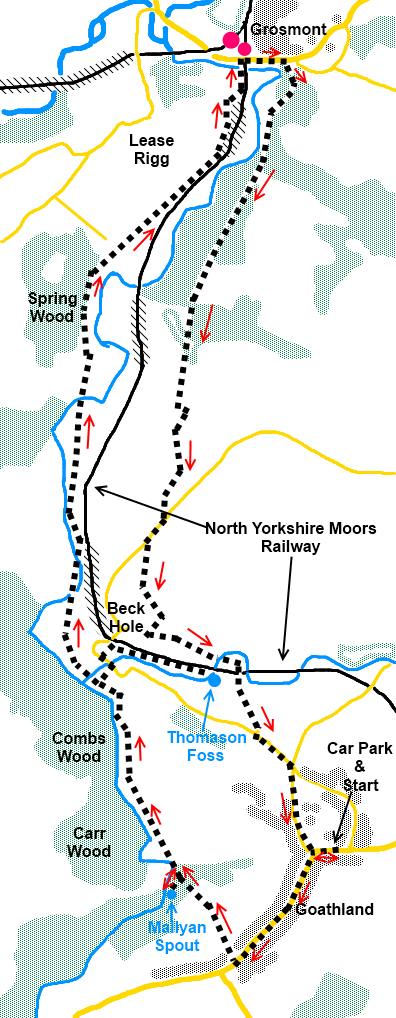
Start:
From the car park in Goathland (NZ 933013), turn right and walk along the
road through the village, ignoring the right turn, until you reach the
Mallyan Spout Hotel opposite the church. Take the footpath via the metal
kissing gate to the right of the hotel (NZ 828007) with the fingerpost to
Mallyan Spout.
After descending a series
of steps, you get to the river (the Murk Esk) and a three way finger post
(NZ 825012).Turn left to Mallyan Spout - 130 metres. This waterfall drops
vertically on the left but may be little evident after dry weather. If you
reach a bridge over the river, you have gone too far!
%20Mallyan%20Spout.jpg)
%20Murk%20Esk%20in%20full%20spate.jpg)
After seeing the waterfall,
retrace your steps to the fingerpost and follow the direction to Beck Hole
¾ mile. After descending a series of stone steps, you get to a stone house.
There is a sign on the fence indicating the course of the old railway line
to the left and right. Turn left briefly then, at a four way fingerpost (NZ
821021), turn right and left at the road for Beck Hole. You are more or less
opposite the Birch Hall Inn which is a “must visit” for anyone who likes
pubs. It is an unusual combined shop/pub and the “bar” is a serving
hatch into the shop.
%20Birch%20Hall%20Inn.jpg)
The next port of call is to
visit Thomason Foss. Continue along the road past the pub and just after
crossing the river bridge, look out for a small public footpath sign on the
right and take this dead end path. Follow it for about 1/3
of a mile until you reach the waterfall (NZ 826022) which is very dramatic
after heavy rain. You pass a point adjacent to the NY moors Railway and a
good spot to see any passing steam trains.
%20Thomason%20Foss.jpg)
Retrace your steps past the
pub to the four way finger post mentioned above and turn right along the old
railway line for Grosmont. Cross a footbridge and follow the sign for
Grosmont and the Esk Valley. Ignore any turns off the old railway track. You
pass what is little more than an isolated row of cottages at Esk Valley (NZ
822043). Keep straight ahead.
As you walk
along railway sidings with various trains etc awaiting renovation by the NY
Moors Railway, the old track is barred by a metal gate. Turn left here then
right through a kissing gate. Through a walkers gate, there is a bench and
from there, is a great view of Grosmont and its railway station. Turn right
here to walk into the village. Walk down the left hand side of the church
and cross a suspension bridge and you are at the railway station (NZ
828053).
%20Steam%20Train%20at%20Grosmont.jpg) Turn right and walk through the village. Walk up
the hill until you reach a small public footpath sign on the right
indicating your route, opposite a large red brick house bearing the name
Parkvilla (NZ 831052).
Turn right and walk through the village. Walk up
the hill until you reach a small public footpath sign on the right
indicating your route, opposite a large red brick house bearing the name
Parkvilla (NZ 831052).
Follow the path down
through the trees. After crossing a footbridge, the path forks, go left. You
join a broad tarmac track go left. Walk along the tarmac for about 250 yards
and look out for a small public footpath sign on the right (NZ 829047). Take
this path which has large cobblestones indicating the way. Through a gate
and the path becomes a broad track through the trees. Although in many
instances they are hidden by debris, note the continued presence of the
cobbles indicating this must have been a major route in ancient times.
Via a stile and footbridge,
the path opens into a field. Follow the right hand boundary and go over the
stile in the opposite corner and follow the path alongside the trees. The
path briefly re-enters the trees via a stile and exits immediately left over
another. Ignore the faint path straight ahead between the two stiles.
The path passes through a
gateway bearing a notice on the opposite side that warns that the river
crossing is closed. We are not going that way but be sure not to take the
right turn down to the river.
At Green End Farm (NZ
825035), turn left and look out for the small green public
bridleway sign on the right after about 100 yards (NZ 826035).
Continue through the next
farmyard and after 100 yards, branch off left following the bridleway below
some old spoil heaps.
On reaching the tarmac
road, turn right and after 200 yards or so, branch off left by the public
footpath sign (NZ 824029). The path follows the contour round the hill. Do
not be tempted to take any faint paths off to the left which climb the hill.
Soon, the path follows the course of a stone wall on the right.
At Hill Farm (where there
are static caravans ) (NZ 824024), turn left along the broad track in the
direction of the solitary finger post on the left, passing Lins farm.
You come in sight of the
railway line at a bench. Go left here. You might catch sight of Thomason
Foss below you.
%20Footbridge%20Under%20Railway%20Bridge.jpg)
Cross the river via a
footbridge which passes under the railway bridge. After climbing the steps,
follow the clear path the road (NZ 829019) and turn left and at the
crossroads with Darnholme Road, turn right to follow the ancient paved road
into Goathland.
%20Centre%20of%20Goathland.jpg)
If you need to buy any
hiking equipment/clothing before your trip see the Hiking
Store
All information on this
site is given in good faith and no liability is accepted in respect of any
damage, loss or injury which might result from acting on it.
|


.jpg)
.jpg)
.jpg)