
|
|
|
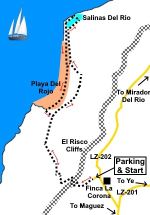
Introduction: You might find this route names as Playa del Rojo, or even El Risco Cliffs but I think it would be more appropriate to describe it as Path of Los Gracioseros (Path of the people of Ilas Graciosa), because that is what it used to be, the main commercial route to the rest of Lanzarote for the people of the island of La Graciosa, who rowed across the El Rio channel, until a proper ferry service was instigated in 1950. This is probably one of the most dramatic and probably most difficult walk on the island, in terms of a long grinding steepness both on the ascent and decent. It is not for the faint hearted and you MUST ensure you have plenty of water. I would also recommend windproof and some warm clothing as breezes/winds can sweep along the cliffs. It is a popular route, not least because of the fabulous sandy beach of Playa del Rojo but this is an isolated beach with no facilities whatsoever and no shelter from the sun. The path drops down the cliffs from about 1171ft (357m) to zero and back again (this is as measured on an ‘elevation’ website but it could be slightly more). The path of necessity zig-zags back and forth to overcome the gradient but it is nevertheless a very steep climb. Because of its length, steepness and rocky nature, I have given it a red ‘traffic light’ marking. Underfoot, the zig-zag path is loose, sharp volcanic rocks ranging from an inch or two in diameter to five or six inches. I saw a few people walking it in trainers but I would strongly recommend wearing walking boots. This is no place to turn an ankle or worse. Once at sea level, the path is level, mostly sandy or gravel and straightforward. But don’t forget you have to go back! There is an outside chance that anyone who suffers from vertigo might have a problem with this walk. The route only exists because it follows the stable ground which followed from the lava flow that came from Montana Corona, which towers over the car park area. The island of La Graciosa was one of the first to be formed and its bay provided shelter for shipping from Atlantic storms. The main town of the island is Calete de Sabo, which is visible across the channel. Its occupants were mainly fishermen. Fish and tourism are the main earners today. Prior to the ferry service, the women of Ilas Graciosa would carry heavy baskets of salt and/or fish up this steep path and on to the town of Haria for sale. On their return, they would light a fire on the beach to tell their husband co come over in their boats to pick them up. I would guess they were well tired! Nowadays, the island receives electricity from Lanzarote and you will pass the final pylon from where the cable disappears under the ground and sea to the island. The Salinas del Rio are the oldest salt producing areas in all the Canary Islands, dating from 1520 but salt production there was abandoned in the 1970s. They are reputedly very colourful at times but I did not see this. The area is within the Natural Park of the Chinijo Archipelago which basically includes the northern tip of Lanzarote plus Ilas Graciosa and associated smaller islands. It is home to various special bird, plant and marine species. There are a number of large boulders by the Salinas on which you can perch for a picnic or the beach at Playa del Roja is superb. The walk starts from quite a large car park at the top of the cliffs. To get there, take the LZ 201 from Haria and at Yé, turn left on to the LZ 202. After just over a quarter of a mile (or just under half a kilometre), look out for a large white painted farm on the right (Finca La Corona). The entrance to the car parking area is on the left after a hundred yards. It has a cobbled track. Start: Follow the obvious path from the rear of the parking area. You will reach an observation area (mirador) with a seat (which you will welcome on the return!). The views are terrific. From here follow the obvious zig-zag path downhill.
Once you reach the bottom, the path becomes fairly level and you loose the rocks underfoot in favour of a gravely path. Follow this until you reach a rough stone cairn at a crossroads of paths and turn right.
Pass and ignore turn on the left. When you reach the edge of the large beach, turn left to follow the path along its edge, through the dunes (the sea is on your left).
As you get to stonier ground, there is a path off to the left but ignore this and keep straight ahead. You reach the edge of the lagoon. I followed the path along its left hand side, which gives you a good view of its extent.
Once you come opposite the ruined building on the left, turn left here on a clear track. Pass the building and make for the shore.
Turn left here to follow the pebbly beach until you get to the electricity pylon. You will see a clear track running along the back of the beach. Follow this eventually rejoining your outward path and retrace your steps.
Alternatively, you can walk along the sandy beach itself, pausing for a sunbathe or swim if you wish. At the end of the beach, look for a path on the left through the dunes. There is not really a precise route and a lot depend on who has walked where previously. However, as long as you head directly towards the cliffs (i.e. try not to shoot of at angles), you will reach the path that formed your outward journey. Turn right to return to the stone cairn, then left back to the zig-zag path. Be aware that it is very difficult to spot the zig-zag cliff path from the beach as it is camouflaged by all the rocks, which is why I say avoid shooting off at angles, to avoid missing the path to the cairn. If you need to buy any hiking equipment/clothing before your trip see the Hiking Store All information on this site is given in good faith and no liability is accepted in respect of any damage, loss or injury which might result from acting on it.
| | |||||||||||||||

.jpg)
.jpg)
.jpg)
%20Montana%20Corona.jpg)
%20Car%20parking%20area.jpg)
%20View%20to%20Graciosa.jpg)
%20Yachts%20moored%20in%20the%20bay%20at%20Ilas%20Graciosa.jpg)
%20Looking%20along%20the%20Risco%20Cliffs%20near%20start%20of%20walk.jpg)
%20Track%20at%20the%20foot%20of%20the%20cliffs.jpg)
%20Playa%20del%20Rojo.jpg)
%20Salinas%20del%20Rio.JPG)
%20Salinas%20del%20Rio%20showing%20different%20cells.jpg)
%20Ruin%20at%20Salinas%20del%20Rio.jpg)
%20Looking%20along%20the%20foreshore%20at%20Salinas%20del%20Rio.jpg)
%20The%20drama%20of%20the%20El%20Risco%20Cliffs.jpg)
%20Unusual%20plant%20growing%20in%20the%20pebbles.jpg)
%20Last%20pylon.jpg)