|
Whitbarrow
Starting point and OS Grid reference:

Rough
parking at Mill Side (SD 452840)
|
Ordnance Survey Map
OL7
The English Lakes – South-Eastern Area.
Buy this map from
List
of OS Maps
Note: If you use OS Maps on-line, you can download this route via this
link.
| |
Distance: 6.8
miles
|
Date of Walk: 21 April 2012
| |
Ascent:
Descent:
See Walking Time Calculator
|
335m (1100ft)
335m (1100ft)
| |
Traffic
light rating:  
(For explanation see My
Walks page)
| |


For advice on .gpx files see
My Walks page
|

Click
the PDF logo above to give a printable version of this walk without the
photos.
|
To
view route as a dynamic Ordnance Survey map click here.
%20Whitbarrow%20from%20Arnside.JPG)
Introduction:
Visits to the Lake District are
always something of a weather lottery. After all, there are Lakes for a
reason! However, quite often when it is raining the proverbial cats and dogs
in the heart of the Lake District, towards the Cumbrian coast, the weather
can be glorious. It was one such day when I wanted a walk near Kendal (where
I was staying) and decided to explore the secret plateau of Whitbarrow. I
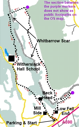
say “secret” because you will not find this route from studying an
Ordnance Survey map as not all the paths to access and cross it are shown.
However they are most definitely there on the ground to those in the know
(which now includes you!) and walkers are welcome.
Whitbarrow (which means white hill) is a
limestone plateau which looks like an escapee from the Yorkshire Dales.
There are even sections of limestone pavement with
its “clints” (limestone blocks) and “grikes” (fissures) which would be more at home at
Malham. It is an area of Special Scientific Interest and part of it is a
nature reserve. There are good views of the coastal estuary over Milnthorpe
Sands and the Lake District hills. Its summit is known as Lord’s Seat.
The terrain of the walk is straightforward
and the amber traffic light is only earned because of the steep descent
down the Bell Rake path although this under ½ mile.
The walk starts from the hamlet of Mill Side.
To get there, turn northwest off the A590, between the A591 and
Grange-over-Sands, where signposted for Mill Side and Beck Head. There is a
rough roadside lay-by on the right immediately after crossing what would
have been the old main road.
There are no refreshment opportunities during
the walk, although there are some excellent vantage points where sandwiches
can be enjoyed. Afterwards, there is the Hiker’s Rest cafe at Beck Head
(if open) or the Derby Inn at the nearby hamlet of Witherslack (just off the
A591) is worth a look.
Start:
From the parking spot (SD 452840), walk up
the lane towards Beck Head. After 200 yards, turn right through a gateway on
to a broad stony track for Low Fell End. There is a public footpath finger
post (SD 450841). At the farm, pass to the right of the farmhouse and go
through the farmyard. At three metal gates, go through the middle one and
proceed along the broad track with hedges at each side.
%20Southern%20End%20of%20Whitbarrow%20Scar.jpg)
As the track swings right into a field, bear
left to a gateway ahead with a yellow footpath arrow. The path starts to
climb through the trees. On meeting a broad track, turn right. Leave the
broad track by the gateway to Whitbarrow Cottage and continue straight ahead
along the narrow path. Good views over the estuary start to appear.
The next turn is a little difficult to spot
but about ¼ mile after passing the cottage, look out on the left for a
footpath climbing steeply through the trees (SD 457849). It leaves the path
you are on between some small rocks at the side of the path. On meeting a
clearer track at a ‘T’ junction (SD 456849), turn left.
The path opens out beneath some impressive
cliffs and crosses exposed bedrock, before returning into the woods through
a fence. About 100 yards beyond the fence, turn right on to a track by an
old bench (SD 454847). A white footpath arrow indicates the route although
this is not obvious from the direction in which you approach.
%20Cliffs%20passed%20during%20the%20ascent.jpg)
Go through a dilapidated wall then almost
immediately turn right through a walkers’ gate back through the same wall.
Stay on the same path as it meanders up through the trees until it comes out
on to the plateau. It then swings round to the left along the broad ridge of
the plateau. The OS map does show a plantation to the north east of the
plateau ridge but this has been felled.
%20View%20over%20Milnthorpe%20Sands%20Estuary.jpg)
The path along the ridge is obvious and
passes a number of cairns. The impressive building in the valley to the left
is Witherslack Hall, built in the 1870s and now a school.
%20View%20along%20the%20Plateau%20and%20one%20of%20the%20cairns.jpg)
%20View%20over%20Witherslack%20Hall.jpg)
%20Limestone%20outcrops%20on%20the%20plateau.jpg)
%20Clints%20and%20Grikes%20on%20Whitbarrow%20Plateau.jpg)
When a stone wall crosses your path, go
through the stone stile into the Whitbarrow Nature Reserve and Site of
Special Scientific Interest.
Cross and ignore a faint path running NE to
SW (SD 442872) (you may not notice this). You also pass a large stone cairn
commemorating Cannon Hervey 1893 to 1967, founder of the Lake District
Naturalists Trust.
%20Cairn%20Commemorating%20Cannon%20Hervey.jpg)
At a clear fork in the path, go left.
Eventually, the path approaches a stone wall
then runs parallel with it. If you see a stone stile through it, ignore
this. The path starts to gently descend until your way is blocked by a wall
with a ladder stile (SD 441879). Do not cross this but instead, turn left to
follow the wall, now on your right. Ignore a stone step stile.
The path passes an old mine shaft on the left
then starts to steeply descend a shale path down Bell Rake, going through a
walkers’ gate in a stone wall. As the path levels out, come to a threeway
finger post (SD 435877) and turn left for “Permitted Footpath to
Witherslack Hall”. The route is sporadically marked with white arrows.
Follow the main broad track through the trees
for a short distance and look out for a narrow footpath off to the left.
Follow this path through the trees.
As you exit the trees, go through the kissing
gate ahead and follow the track as it swings round to the right. At the road
by the entrance to the school (SD 437859), turn left.
%20Chapel%20Head%20Scar.jpg)
Walk along the road for just less than ½
mile then turn left on to a broad public bridleway with a fingerpost for
“Beck Head” (SD 438853). Follow this to Beck Head where there is a
little cafe – the Hiker’s Rest – where you might get refreshment if
open. The bridleway becomes a tarmac road. At the junction, turn left back
to the car.
%20Peaceful%20Scene%20at%20Beck%20Head.jpg)
If you need to buy any
hiking equipment/clothing before your trip see the Hiking
Store
Before
venturing on to the Lake District fells, for your own safety, please check
the Fell
Top Conditions
All information on this
site is given in good faith and no liability is accepted in respect of any
damage, loss or injury which might result from acting on it.
|


.jpg)
.jpg)
.jpg)