|
Grisedale
Pike
Starting point and OS Grid reference:

Car
park just outside Braithwaite Village (NY 227238)
|
Ordnance Survey Map
OL4
English Lakes – North Western Area.
Buy this map from
List
of OS Maps
Commission from map sales is
used to fund the website, so keeping it free to use.
| |
Distance: 6.5
miles
|
Date of Walk: 2 November 2011
| |
Ascent:
Descent:
See Walking Time Calculator
|
752m (2467ft)
749m (2459ft)
| |
Traffic
light rating:


(For explanation see My
Walks page)
| |


For advice on .gpx files see
My Walks page
|

Click
the PDF logo above to give a printable version of this walk without the
photos.
|
To
view route as a dynamic Ordnance Survey map click here.
Introduction:
Sometimes walks do not pan out as you
expect. In this case, the walk was supposed to be the Coledale Round, a
pretty hard 11 mile or so (depending on which peaks are included) horseshoe
walk from the village of Braithwaite near Keswick. Grisedale Pike is the
first peak in the round and is tough in that you go from virtually nothing
to 2595ft in under 2 miles. My companion and I completed this and, although
we expected strong winds, nothing prepared us for the true gale force we met
as we crested the summit. We battled on briefly but with only our walking
poles (out sideways at 45 degrees!) preventing us from disaster. Then, just
ahead of us, a lone walker was literally blown away and landed in a stunned
immobile heap about 10 feet from where he started. After making sure he was
ok, we (and he) decided attempting to complete the round was foolhardy and
we opted for the escape route at the head of the valley back down the low
level old miners’ track.
However, Grisedale Pike is
a perfectly respectable walk in its own right for anyone without the time or
inclination to do the full round. It is easy to find the route and offers
very good views. The walk starts from Braithwaite village, or more correctly
from a parking area just outside the village on the B5292 Winlatter Pass
road. For Braithwaite itself, turn west off the A66 between Cockermouth and
Keswick, close to Keswick.
Refreshments are available
after your walk at the Royal Oak or Coledale Inns in Braithwaite.
As you leave the village on
the B5292, the parking area is on the left after a sharp right hand bend and
immediately before a blue parking sign which tells you of parking in
½ mile.
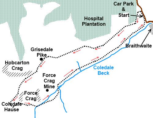
Start:
As you enter the car park, note the steps on the right which are where you
start and the track with a barrier to the left which is where you will
return.
Climb the steps following
the fingerpost for Grisedale Pike.
%20Skiddaw%20and%20Blencathra.jpg)
%20Causey%20Pike.jpg)
At the top of a rise, the
path becomes a grassy path and forks. Take the right fork. The path up the
Sleet How Ridge to the summit is obvious and you only need to follow this.
%20Grisedale%20Pike.jpg)
%20Ridge%20up%20Grisedale%20Pike.jpg)
%20Hopegill%20Head%20and%20Grasmoor.jpg)
From the summit (NY
199226), there is a gentle descent and above Hobcarton Crag, bear left to
Coledale Hause (NY 188212). From here there are good views west to the tip
of Crummock Water and on the right of the valley, the impressive Gasgale
Crags.
%20View%20west%20from%20Coledale%20Hause.jpg)
%20Coledale%20from%20Coledale%20Hause.jpg)
The return route is clear,
as you face north east from the centre of Coledale Hause, there is a clear
track which heads back down the valley. There are actually two paths but the
clearest one (starting at NY 190212) drops you on to the broad gravel track
just north east of the ugly remains of the Force Crag Mine buildings. As you
descend to this point, the waterfalls flowing over Force Crag itself can be
quite impressive.
%20Force%20Crag.jpg)
The broad gravel track
takes you straight back to the car park.
If you need to buy any
hiking equipment/clothing before your trip see the Hiking
Store
Before
venturing on to the Lake District fells, for your own safety, please check
the Fell
Top Conditions
All information on this
site is given in good faith and no liability is accepted in respect of any
damage, loss or injury which might result from acting on it.
|


.jpg)
.jpg)
.jpg)