|
Sharp
Haw and Rough
Haw
Starting point and OS Grid reference: 
Rough
parking on Bog Lane out of Stirton (SD 975540)
|
Ordnance Survey Map
OL2
Yorkshire Dales – Southern and Western Areas.
Buy
this map from
List
of OS Maps
Note: If you use OS Maps on-line, you can download this route via this
link.
| |
Distance: 6.3 miles
|
Date of Walk: 10 August 2012
| |
Ascent:
Descent:
See Walking Time Calculator
|
1190ft (363m)
1191ft (363m)
| |
Traffic
light rating: 
(For explanation see My
Walks page)
| |


For advice on .gpx files see
My Walks page
|

Click
the PDF logo above to give a printable version of this walk without the
photos.
|
To
view route as a dynamic Ordnance Survey map click here.
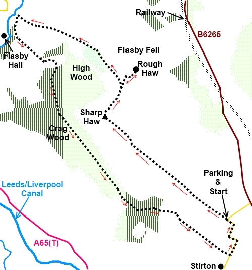
Introduction:
Less than three miles from the centre of Skipton, Sharp Haw seems like a mere pimple at only 1171ft (357 metres) but
it earns its “Sharp” credentials by being a distinct conical hill which
stands out in the landscape for miles around. From its summit is a
spectacular 360° panorama which is achieved with very little effort, and
so, Sharp Haw is well worth a trip.
The walk starts from the very boundary of the
Yorkshire Dales National Park and after the saunter up Sharp Haw itself to
enjoy the view, wanders across Flasby Fell to Rough Haw, then to the
outskirts of Flasby hamlet before returning through Crag Wood.
This would be a great walk to introduce
children to the joys of fell walking as they get to conquer a distinct
“mountain”, complete with trig. point.
There is a public bridleway across Flasby
Fell but initially, this walk largely ignores this and takes a path which,
although not marked on the OS map, is very clear on the ground.
The walk starts at a wide track leading from
some rough parking on the narrow Bog Lane out of Stirton, a small hamlet
just outside Skipton off the A65. Proceed north east along Bog Lane passing
Tarn House Farm. There is then a sharp left hand bend, a sharp right hand
bend, another sharp left hand bend then at the next right hand bend, park
there. I spell this out in detail because if you miss this parking spot,
there is nowhere else along the lane, even to turn round and you will finish
up at the busy B6265 to Grassington with difficult visibility for pulling
out or turning round. The other problem is that the parking is very limited,
no more than for 4/5 cars. If full, the best advice would be to turn round
utilising the entrance to the track and return to Stirton where there is
some room to park on the road, then walk back along Bog Lane to the start of
the walk. Depending on where you park, this could add ¾ mile to the overall
diatance.
There are no refreshment opportunities en
route. The top of Rough Haw has some flat-ish rocks useful for a picnic.
Start:
From the parking (SD 975540), walk along the broad track marked by a green arrow,
following the left boundary wall and heading north west. Already, you can
see the distinctive summit of Sharp Haw. At
this point you are following the marked bridleway.
%20Sharp%20Haw%20and%20Rough%20Haw.jpg)
After going through two gateways, the track
splits. Take the right fork indicated by a green arrow and follow the fence
on the right hand side.
Go through a gate indicating you are entering
Open Access land and follow the clear track for Sharp Haw ahead.
%20View%20SW%20towards%20Elslack%20Moor.jpg)
%20View%20NE%20towards%20Embsay%20Moor.jpg)
%20View%20over%20Rough%20Haw.jpg)
Shortly after turning right at a public
bridleway fingerpost and crossing a plank bridge, the path divides (SD
969545). The official footpath/bridleway goes more or less straight on but
you branch off left heading for the summit. The summit is attained shortly
after crossing a metal ladder stile (SD 959553).
%20Summit%20of%20Sharp%20Haw%20&%20Trig%20Point.jpg)
The views are spectacular. You are looking
down on the village of Gargrave. The distinct shape of Pendle Hill is in the
distance to the south west and to the north east, the craggy edges of
Rylstone and Cracoe Fells with their War Memorial and obelisk are clearly
visible.
%20Looking%20down%20to%20Gargrave.jpg)
%20Cross%20&%20war%20memorial%20on%20Cracoe%20Fell.jpg)
%20View%20along%20Sharp%20Haw%20summit.jpg)
The hill in the near distance to the north
east is Rough Haw (SD 963559). To get to it, ignore the path which continues
along the ridge but from the trig point branch off to the right, descending
past a large rock on the left and go through the gap in the wall. Follow the
path down to a walkers’ gate and go straight ahead up Rough Haw. The path
to its top branches off to the right, part way up.
%20Summit%20of%20Rough%20Haw%20with%20Sharp%20Haw%20behind.jpg)
After “conquering” Rough Haw, retrace
your steps to the walkers’ gate and without returning through it, turn
right.along the obvious path. Follow this path downhill, heading for the
right hand end of the trees (SD 959561). The path follows the boundary wall
around the trees.
When the trees stop, continue to follow the
boundary wall to some more trees where there is a gate. Stay on the obvious
track through this gate and one at the next at the end of the field.
Cross a farm track through two metal gates
and follow the walled track ahead. This exits the trees at a stony farm
track. Follow this for a few yards then turn left at the junction (SD
948566), following the finger post for Stirton.
The track passes some farm buildings and
heads for the trees and just after going under some power lines, as it
curves to the left, continue straight ahead.
Go through a metal gate and the path climbs
gently, curving first left then right into the trees via a kissing gate
(SD
953559). Stay on the main track until it divides at a bench. Go right here
following the fingerpost for Stirton. At the broad forestry track, turn
left.
Stay on the main forestry track to a junction
where you go left. Stay on this main track and as it curves sharply left at
the end of the trees, go straight ahead to find a stile (not easy to spot).
Once over the stile, the path goes straight
across the field to a gated stile at the far side. Follow the left hand
boundary of the next two fields. Cross another stile and bear slightly left
to a wooden stile on the right into another field where you continue to more
or less follow your original line along the right hand boundary.
At the road (SD 976535), turn left to return
to the parking (or right if you have had to park in Stirton).
%20Carving%20at%20Tarn%20House%20Farm.jpg)
If you need to buy any
hiking equipment/clothing before your trip see the Hiking
Store
All information on this
site is given in good faith and no liability is accepted in respect of any
damage, loss or injury which might result from acting on it.
|


.jpg)
.jpg)
.jpg)