|
Rylstone
Cross and Cracoe War Memorial Ridge
Starting point and OS Grid reference:

Lay-by yards north of the village pond at Rylstone, on the B6265 between
Skipton and Grassington (SD 969588).
|
Ordnance Survey Map
OL2
Yorkshire Dales - Southern & Western Areas.
Buy
this map from
List
of OS Maps
Note: If you use OS Maps on-line, you can download this route via this
link.
| |
Distance: 6.6 miles
|
Date of Walk: 17
February 2015
| |
Ascent:
Descent:
See Walking Time Calculator
|
1206ft (368m)
1209ft (368m)
| |
Traffic
light rating:


(For explanation see My
Walks page)
| |


For advice on .gpx files see
My Walks page
|

Click
the PDF logo above to give a printable version of this walk without the
photos.
|
To
view route as a dynamic Ordnance Survey map click here.
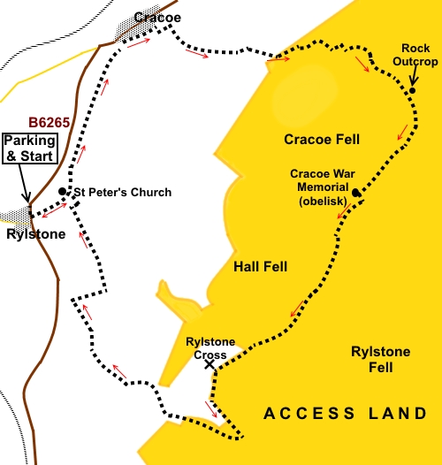
Introduction: Rylstone
Cross and Cracoe War Memorial ridge is a popular Yorkshire Dales walk for
those who know it but it may elude those who don’t, because it is not
covered by Rights of Way on the OS maps. It is the ridge which looks down on
you as you drive along the B6265 between Skipton and Grassington. The cross
and the memorial are prominent landmarks which sit at either end of the
ridge.
The
ridge, which is on the edge of Barden Moor, is also covered as part of my
Upper Barden Round walk but this is a shorter route for those who just want
to do the cross and memorial ridge.
The
walk starts from a lay-by at the village of Rylstone. Apart from the cross,
its claims to fame are that it is home of the real Calendar Girls and it
featured in a poem by William Wordsworth, The White Doe of Rylstone (or, The
Fate of The Nortons). This is too complex a tale to explain here!
Sitting
at the southern end of the ridge, Rylstone “Cross” was originally a
large man-shaped rock, known as “The Stone Man”. A wooden cross was
subsequently erected to celebrate the “Peace of Paris” in 1783, a number
of treaties which ended the American War of Independence. Finally, the
current cross was erected in 1995.
Cracoe
War Memorial to the locals who perished in the two World Wars, sits at the
northern end of the ridge and is in the form of a massive obelisk.
Views
all along the ridge are far reaching and both monuments provide for good
picnic spots amongst the rocks.
For
the majority of this walk, route finding is easy. However, most descriptions
which I have seen, describe it in an anti-clockwise direction. Having been a
victim in the past and having met others who have also suffered, I can say
with confidence that trying to find a particular,
described, descent route from the
Cracoe War Memorial end is all but impossible, as there are no clear paths.
One ends up cursing one’s way down an unpleasant steep descent of rough
and in some places severely furrowed grass, with no clear point of
reference. At best, it does not do the knees any favours!
A
clockwise ascent is (a bit) easier to describe and at worst, you know where
you are aiming for – the top! It does not matter at which point you reach
the ridge. You just turn right when you get there. Here, it is Access Land
so in essence, the route is up to you. The GPX route is based on the track
of my actual ascent.
The
walk starts from a lay-by yards north of the village pond at Rylstone, on
the B6265 between Skipton and Grassington.
Please
note there is no access for dogs on Barden Moor as a result of one of 52
bylaws which were introduced by the Yorkshire Dales National Park Authority
when the 11th Duke of Devonshire introduced open access on to
Barden Moor in 1969. The 52 byelaws were introduced in the main for
conservation purposes.
Start: :
From
lay-by (SD 969588), cross the B6265 and head up the obvious lane opposite
the village pond, following the fingerpost for “Rylstone Church” and
“Manor House Farm”. Continue straight ahead at the church, ignoring the
route off to the right which is your return path.
%20Village%20Pond%20at%20Rylstone.jpg)
%20View%20of%20ridge.jpg)
At
the farm, head through the gateway, just to the right of the farmyard, and
walk along the track to the left of another pond. You now follow this track
for three quarters of a mile. It soon becomes a walled lane.
%20Moss%20covered%20stone%20sink.jpg)
The
track curves back to the B6265 but just before you get to the road, turn
right on to what is almost a secret and very pretty lane into Cracoe (Back
Lane) (SD 976560). Passing tourists would never learn of this lane. Follow
it through the village and round a 90° right turn.
%20Secret%20Lane%20into%20Cracoe.jpg)
Turn
left at the next junction and after 100 yards, arrive at a ‘T’ junction
where you are faced with an information board about Barden Moor and Barden
Fell Access Areas. Turn right here (SD 980601).
Follow
this walled lane past two distinct copses of trees. 100 yards or so after
the second, the walled lane ends at a series of sheep pens. Go through the
farm gate on the left (SD 987598).
A
faint path starts, following the wall and as you progress starts to very
gradually move away from it. There are a couple of places where you might be
tempted by tracks going off to the right but my advice would be to ignore
these.
This
is where describing a route becomes difficult. You may notice what I can
only describe as a “knobbly bit” of hillside ahead of you, with a number
of deep gullies/furrows leading it its direction (SD 993599). If you go
right and uphill here, you should see a reasonable way to ascend.
%20View%20up%20Wharfedale.jpg)
Not
far above this, I followed faint quad bike marks uphill. As an aiming point,
if you look up the hill you should be able to see what at first glance looks
like a ruin but is actually a rocky outcrop – see picture. You are aiming
to pass just to the right of this (SD 997596).
%20Rock.JPG)
Once
you get to this outcrop, just continue uphill and you will soon see the wall
which runs along the ridge. I arrived just by a large flat rock (SD 997593).
Turn right at the wall.
%20View%20along%20ridge%20to%20war%20memorial.jpg)
%20Cracoe%20War%20memorial.jpg)
At
the war memorial (SD 993588), you need to climb over the wall via the ladder
stile, then, turn right to follow the wall all the way along the ridge.
%20View%20across%20Wharfedale.jpg)
%20Rylstone%20Cross.jpg)
%20View%20towards%20Pendle%20Hill.jpg)
%20Looking%20back%20to%20Rylstone%20Cross.jpg)
At
Rylstone Cross (SD 982576), if you want a closer look and to see the view,
there is another ladder stile but otherwise, follow the wall down until you
meet a clear path at a ‘T’ junction, by a gate (SD 985571). Turn right,
through the gate.
As
you go through a depression, the track becomes wider and the correct route
is now crystal clear.
Follow
the track down to another ‘T’ junction by a three way fingerpost. Turn
right (SD 974577) for ”Rylstone”. There is another information board
here about Barden Moor and Barden Fell Access Areas.
After
a quarter of a mile, where there is a three way fingerpost turn right
through a gate by a copse of trees for “Rylstone Church” to
follow a curving path to back to
St Peter’s Church (SD 973581). Turn left at the church, back to the car.
%20St%20Peter's%20Church%20Rylstone.jpg)
If you need to buy any
hiking equipment/clothing before your trip see the Hiking
Store
All information on this
site is given in good faith and no liability is accepted in respect of any
damage, loss or injury which might result from acting on it.
|


.jpg)
.jpg)
.jpg)