
|
|
|
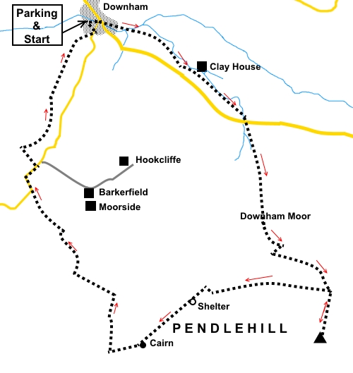
To view route as a dynamic Ordnance Survey map click here. Introduction: Pendle Hill is one of the most visited Lancashire walks. The hill has a distinctive shape and if you have ever looked south from a Yorkshire Dales vantage point and wondered “what is that hill”, the chances are it was Pendle. From its summit at 1827ft (557 metres) there are good views north, to the Ribble Valley and the Yorkshire Dales beyond and south towards Colne. This route starts from the very pretty village of Downham and is an alternative route to my other Pendle Hill walk from Barley. Overall, this is a very easy walk to navigate, using clearly defined paths. Downham is an “estate” village, owned by Lord Clitheroe. He also owns Pendle Hill and the route across the hill makes use of concessionary paths. To get to Downham, turn off the A59 just east of Clitheroe. It is signposted although you initially turn off north before passing south over the A59 via a fly-over. There is a free public car park in Downham with toilets. Even if you do not need the services of the toilets, it is worth having a look. They are unusual (I won’t spoil the surprise!). The village also has a pub. You will pass a shelter on Pendle Hill, which has a seat should you wish a picnic and it is also possible to get out of the prevailing wind on the east side of the summit by the Barley footpath. Start: Exit the car park (SD 785441) via walkers’ gate close to the toilets. Go straight ahead, crossing the stream by a small bridge.
Turn right along the road, then fork left to walk parallel with Downham Beck (SD 786441). Continue through a walkers’ gate by some cottages and continue to follow the stream, in the direction of the public footpath fingerpost. After 300 yards or so, follow the direction of the waymarker, away from the beck. In the far right hand corner of the field, go through a walkers’ gate and follow another stream. Cross a broad farm track which leads (left) to Clay House and continue up the left hand side of the field beyond after going through a walkers’ gate. Cross a stone step stile by an old barn (SD 798434), where there are a couple of benches to admire the view. Turn left and at the bottom of a gully, turn right over a stile and up the rough steps beyond. Go through a kissing gate on to the road (SD 798433) and continue immediately opposite. Cross a stile on to open countryside and keep straight ahead on the obvious path, which is now a concessionary path (brown on the OS map). At SD 800423 the path divides. The path straight ahead is the steeper ascent up Pendle Hill. I opted for the left hand path which zig-zags to lessen the gradient. As you climb, there are good views behind you over the Ribble Valley and towards Ingleborough. North West is the Hanson Cement Works, usually with a plume of white smoke.
After the climb and as the ground levels out, you arrive at a kissing gate. To the right here, before going through the gate, there is a well worn path which is the onward route after visiting the trig. point. Go through the gate, close to which is a shelter and head about 45° right (192° magnetic) to visit the trig. point which should be visible. There are good views from the trig. point (SD 805414), so it is worth the trip! [Note the kissing gate - replacing a ladder stile - and shelter were not present when I did the walk but have subsequently been reported by a follower of my route. The unusual name Kpacota, after a bit of Googling seems to mean "beauty" in Russian].
Return to the ladder stile, cross it and turn left. The well used path crosses the backbone of Pendle Hill, going over a ladder stile, passing a round shelter (SD 793418) and on to a large cairn (SD 789414). This was originally built to commemorate a former doctor from Clitheroe and scout district commissioner Gordon 'Peri' Hampson, who died in 1985.
At the cairn, bear off right at about 45°, downhill (273° magnetic), following the clear path. As you descend, there is a curious hill below with rocky outcrops. This is Worsaw Hill.
The path leads down to the corner of two walls. Turn left. The path crosses two small valleys, the route being indicated by some stone marker posts. It turns away from the wall before dropping down quite a steep banking to a walkers’ gate (SD 783423). Go through this and follow the track, initially alongside a wall. The track becomes a tarmac lane. Keep straight ahead ignoring any turns off. At the junction, keep straight ahead following the road sign for “Downham 1 mile”. Follow the road round a sharp right hand bend and after 100 yards, turn left for Worsaw Hill Farm, following the yellow footpath arrow (SD 780429).
Follow the far track over the stream and as it bends left to the farm, branch off right to a small gate. Through this, turn right to follow the track alongside the wall. Go through a couple of kissing gates and initially keep to the left hand side of the field beyond. When the field widens out, continue in your same direction towards the wood in the distance. At the far end of the field, bear right to a kissing gate. Through this, follow the left hand boundary in the next two fields. The path then continues between a fence and a wall back to Downham. If you need to buy any hiking equipment/clothing before your trip see the Hiking Store All information on this site is given in good faith and no liability is accepted in respect of any damage, loss or injury which might result from acting on it.
| | |||||||||||||||||

.jpg)
.jpg)
.jpg)
%20Downham.jpg)
%20Downham%20Beck.jpg)
%20View%20noprth%20over%20Ribble%20Valley.jpg)
%20View%20towards%20Ingleborough.jpg)
%20Looking%20up%20at%20Pendle%20Hill.jpg)
%20View%20NW%20with%20cement%20works.jpg)
%20Shelter.jpg)
%20Pendle%20Hill%20Trig%20Point.jpg)
%20Looking%20North%20along%20the%20edge%20of%20Pendle%20Hill.jpg)
%20View%20to%20Black%20Moss%20Reservoirs.jpg)
%20Circular%20shelter.jpg)
%20Scout%20Memorial%20cairn.jpg)
%20Worsaw%20Hill.jpg)
%20Pendle%20Hill.jpg)