|
Pendle
Hill
Walk From Barley
|
Starting
point and OS Grid reference:
Barley
village – “honesty box” car park (SD 823404)
|
Ordnance
Survey Map
OS
Explorer OL41 Forest of Bowland and Ribblesdale.
Buy this map from
List
of OS Maps
Note: If you use OS Maps on-line, you can download this route via this
link.
| |
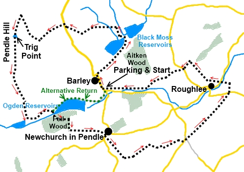
Distance: 9.2
miles (or 5 miles for the reduced walk)
| |
Traffic light rating:
  (or shorter walk
see text).
(or shorter walk
see text). (For explanation see
My
Walks page)
| |


For advice on .gpx files see
My
Walks page
|

Click
the PDF logo above to give a printable version of this walk without the
photos.
|
To
view route as a dynamic Ordnance Survey map click here.
%20Pendle%20Hill.jpg)
Introduction:
Pendle Hill is one of the most
visited Lancashire walks. The hill has a distinctive shape and if you have
ever looked south from a Yorkshire Dales vantage point and wondered “what
is that hill”, the chances are it was Pendle.
This Pendle Hill walk is useful in that it
can be treated as a straightforward 5 mile walk of the hill itself or
extended if time/weather/inclination permit. The shorter option goes via the
green dotted route shown on the sketch map. An alternative route up Pendle
Hill can be seen at my Pendle
Hill From Downham walk.
The walk starts from the pretty village of
Barley and takes a route via one of the Black Moss Reservoirs, rather than
heading in the conventional direction straight for the hill. The way chosen
up the hill is the steepest but takes you first to its northern end from
where there are good views towards the Yorkshire Dales. Along the top, there
are good views across the Forest of Pendle.
The descent brings you down by Ogden
Reservoirs from where you have the shorter option of an easy one mile walk
along the track back to Barley. However, on the day I did the walk, the
decision was to extend it to take in Newchurch in Pendle with its pretty
church and along a higher part of the Forest of Pendle to Roughlee. This
latter section provided some surprisingly good views.
The area is of course well known for the
Pendle Witches, a true story of a number of women who were executed in the
16th century for witchcraft. This has resulted in a minor tourist
industry exploiting references to the witches and not least the use of witch
characters on some of the footpath signposts for the Pendle Way, part of
witch (sic) features in this walk.
Unfortunately there is some inconsistency and some of the junctions only
have normal yellow footpath arrows.
The walk is easy apart from the steep walk up
Pendle Hill itself, which attracts the amber traffic light, marginally short
of a red. The path is quite steep but it is not too long and is well
“manicured” with rock paving to reduce erosion. Certainly even a
relatively inexperienced walker should not have undue difficulty.
In Barley village where there is a public
“honesty box” car park and toilets where we start. The Pendle Inn in
Barley makes useful refreshment stop at the end of the walk. There is also a
tea room in Newchurch in Pendle and another roadside café en route.
Directions to Barley would be very different
according to which direction you come from so it is best to consult an
atlas/sat. nav. or my Google map showing the starting point for all my
walks.
Start:
From the car park, (SD 823404) go to left of the toilets and follow the path
across the green to the road and turn right. Walk along the main street,
passing Barley Mow restaurant which is on the right.
Shortly after the Methodist Chapel, turn
right along a broad track signposted “Blacko” which will take you to the
first Black Moss Reservoir. Walk along the track to the end of the reservoir
and turn left.
%20Lower%20Black%20Moss%20Reservoir.jpg)
At the farmhouse
(Foot House Gate), turn right. As you get to the next farmhouse, take
the footpath off to the left over a stile. The path crosses a couple of
fields to another farmhouse (Higher Laithe). Go through the gate and
straight ahead, following the drive. As you pass the last building, turn
right over a stile marked with a yellow footpath arrow.
About 20 yards beyond the stile, bear left
indicated by the footpath arrow. The path is now indistinct but simply head
towards the right hand end of Pendle Hill ahead. You will come to a narrow
stile through the wall into the road. Turn right along the road, then left
along the drive to Pendle House and Pendle House Farm
(SD 814416). There is a public bridleway fingerpost.
At a junction of tracks, the way is clearly
marked with a white painted direction arrow on the wall for “Pendle”.
Follow the track through the trees and just after going under the power
lines, take the right fork.
As you come to the gate of the next farm,
turn right. The path splits. Take the right hand fork, where the path has
stone slabs and go through the kissing gate (SD
809413). The steep ascent begins!
%20Nearing%20Pendle%20Hill%20summit.jpg)
Climb to the top and stop to admire the view
and catch your breath. Ahead of you is a stone stile. Do not
go over this but turn left, initially to follow the wall but very quickly
the trig. point over to the left and the path to it come into view.
%20Pendle%20Hill%20Summit.jpg)
%20Pendle%20Hill%20Trig.%20Point.jpg)
From the trig point, follow the edge of
Pendle Hill. The path is initially marked with large cairns.
You pass the top of an alternative path up
the hill on the left, which you ignore.
%20Lower%20Ogden%20Reservoir.jpg)
As your path descends, it becomes fainter and
in fact there is no path shown on the OS map but it is clear enough to make
out on the ground. You come to two kissing gates. Go through both these
ignoring the path off to the left and follow the right hand field boundary
to the concrete track at the bottom. Turn right on this.
This leads down to another track, where you
turn left (SD 809398). The dam of the Upper Ogden Reservoir is to your
right. You have now joined the Pendle Way.
If you want to return to Barley now, simply
keep straight ahead on this track – which reduces the walk to 5 miles.
Otherwise, just before Lower Ogden Reservoir, turn right by the signs for
the Firefly Fishing Club, crossing the stream via the bridge made of
sleepers. Pass a small stone bench and continue uphill through the trees on
the obvious stepped path.
Turn right on exiting the trees and walk
alongside them. As they end, go over the stile and turn left.
%20View%20of%20Pendle%20Hill%20and%20ascent%20path.jpg)
Follow the left hand boundary of the next two
fields. As you come in sight of a small brick (utility) building, bear right
to a stout footpath marker post. From here head downhill to Newchurch in
Pendle with its Witches Galore teashop. There are public toilets here too.
%20Parish%20Church%20in%20Newchurch%20in%20Pendle.jpg)
Turn right along the road to the 16th
century Parish Church of St Mary. Here we leave the Pendle Way. Go into the
churchyard and turn left in front of the church and through the gate. Turn
right along the narrow walled footpath.
Stick to the right hand side of the playing
field and follow the little footpath beyond to arrive on the outskirts of
the hamlet Spen Brook. Turn left along the broad track.
At the white painted building, walk along its
left hand side. Pass Spen Barn Farm. At Lower Dimpenley Farm, turn right.
As the track forks at a gateway (SD 834 392),
keep left then, on joining the tarmac drive, turn right. Keep on this main
track and just after a bend, turn left over a stile with yellow footpath
arrows on to a footpath (SD 836392). There is a little sign “Old Laund
Booth Circular Walk”.
Follow the right hand boundary of that field
and on reaching a tarmac track, turn right then left on reaching the road.
As the road bends right at a café (Noggarth
Top Cottage) (SD 839393), keep straight ahead through the kissing gate.
Follow the right hand boundary of the field on a raised banking, then
straight ahead on the track. At a ‘T’ junction in front of a covered
reservoir (SD 844399), turn left, as indicated by yellow arrows, and follow
this track. At the next junction, turn left and continue to the road.
%20View%20towards%20Nelson.jpg)
%20Rural%20View.jpg)
At the road (SD 848403), briefly turn right
then at the bend, before the sign for Barrowford, turn left off the road.
There are two public footpath fingerposts here and you need to follow the
one pointing to the left.
Walk diagonally down this field. You go for
less than 200 yards before going left on to the Pendle Way once more, down
to some stepping stones across the river. The problem is that this left turn
is invisible on the ground – or was when I did the walk. If you have
problems finding this or the stepping stones, continue to the far bottom
corner of the field where there is a bridge to the road where you turn left.
%20Stansfield%20Tower.jpg)
Over the stepping stones, cross the road (or
after 3/400 yards on the road depending on which way you went, and look out
for the footpath on the right) and proceed along a broad track to the left
of a barn. The yellow footpath sign here bears the witches emblem.
As the track bends right, go straight ahead
through the gate following the witch footpath arrow. The footpath curves
right. Ignore the footpath off to the left. Go over a footbridge and up the
hill.
At a tarmac drive, turn left to the road and
at the road turn left following the road downhill in the direction of the
yellow arrow for about 80 yards. Turn right for “Intake Farm” (SD
838407).
At the farm gate, turn right and then after
crossing a little plank bridge, take the path to the right through the trees
and on coming out at the drive to the outdoor centre by a small brick
building, turn left (SD 832405). The Pendle Way witches should still be with
you! At the junction, turn left and right at the next junction.
The track now follows the course of the
stream back to the car park where you started.
If you need to buy any
hiking equipment/clothing before your trip see the Hiking
Store
All information on this
site is given in good faith and no liability is accepted in respect of any
damage, loss or injury which might result from acting on it.
|


.jpg)
.jpg)
.jpg)