|
Settle
to Birchshow Rocks
Starting point and OS Grid reference:

Settle
– pay and display car park (SD 819638)
|
Ordnance Survey Map
OL41 – Forest of Bowland & Ribblesdale.
Buy
this map from
List
of OS Maps
Note: If you use OS Maps on-line, you can download this route via this
link.
| |
Distance: 9
miles
|
Date of Walk: 5 November 2014
| |
Ascent:
Descent:
See Walking Time Calculator
|
710ft (216m)
708ft (216m)
| |
Traffic
light rating: 
(For explanation see My
Walks page)
| |


For advice on .gpx files see
My Walks page
|

Click
the PDF logo above to give a printable version of this walk without the
photos.
|
To
view route as a dynamic Ordnance Survey map click here.
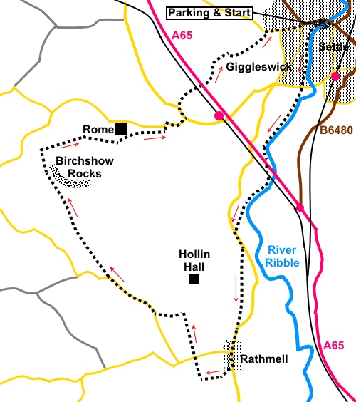
Introduction:
This walk from Settle
breaks with the norm in that instead of heading North or East into the
Yorkshire Dales proper and the limestone country, it heads South-West along
the river before visiting the village of Rathmell and Birchshow Rocks.
Rathmell is a small
village, probably outside of most people’s knowledge. It has little to
exert a particular pull in itself but it is in the most fantastic location
with amazing views. The centre is dominated by a reading room built in the
early 20th century Reading
rooms were generally built by philanthropists to encourage the poor to read,
play games or socialise (instead of going to the pub!). They usually had the
daily papers. The other building of note is Holy Trinity Church.
Birchshow Rocks is an
outcrop of gritstone with many scattered boulders. It is sometimes used by
climbers for “bouldering”. There are some useful spots amongst them for
your “sarnies”, whilst you sit in the sun (hopefully) admiring the view!
The walk nears its
conclusion passing Giggleswick School with its distinctive domed chapel.
According to the chapel guide, the dome was a requirement of the donor of
the funds to build the chapel, reflecting his experience in Palestine. The
chapel was opened in 1901.
What is quite surprising
about this walk is the number of great vistas seen during the circuit.
Pendle Hill, Pen-y-ghent,
Whernside and
Ingleborough all come into view at
various times. The general views too are very attractive. All this for
relatively little effort, the highest point only being around 800ft and you
start at 500ft!
Because most walkers are
heading in the opposite direction, you are likely to see few others on this
route. This means some of the footpath sections are not well worn but
overall, navigation is not too difficult. The start is straightforward as it
follows the Ribble Way.
The walk starts from the
pay and display car park next to the main B6480 in the centre of Settle.
There are public toilets here.
If doing this walk after
wet weather, gaiters will be useful!
Start:
Exit the car park on to the B6480 and turn left. Cross the bridge over the
River Ribble and turn immediately left on the well surfaced riverside path,
following the sign for Giggleswick. Keep following the river when the path
divides.
%20Pen%20y%20ghent%20from%20Settle%20Bridge.jpg)
%20Settle%20Road%20and%20Footbridges.jpg)
%20River%20Ribble%20near%20Settle.jpg)
On reaching some houses,
(SD 813635), follow the road (Sandholme Close) through them and at the
‘T’ junction (with Station Road) turn left. Almost immediately, turn
right off the road, through a walkers’ gate following a fingerpost
“Public Footpath Ribble Way” and “Rathmell 2½ miles”.
Continue to follow the
river under the A65 and the railway bridge. After less than half a mile
beyond the railway bridge, when the river turns quite definitely left (SD
806617), bear right to cross a footbridge. Once over it, turn left. You are
looking for a stone stile. This was quite difficult to spot when I did the
walk as I was facing a low sun and the stile itself is somewhat
“camouflaged” by fencing. Find a short isolated section of wall, which
is where the stile hides. Cross this stile and then another footbridge in
the next field.
%20Looking%20back%20to%20the%20railway%20bridge.jpg)
Follow the path to the road
and turn left (SD 805614). You leave the Ribble Way here, so ignore the
footpath opposite.
Walk along the road for 200
yards or so and about the same distance before you get to the stone barn on
the right, turn right over a stone step stile to follow the public footpath
fingerpost (SD 805613).
Cross another stile (right
of the hole in the wall for the sheep).
At the track leading to the
farm, go through the gate to the left of the track (by a cattle grid) and
bear left to another gate. Through this, follow the right field boundary to
two stiles. Cross these and keep straight ahead.
Go through the gate in the
far right hand corner then, turn left to follow the left boundary to the
road.
Turn right along the road
into Rathmell.
%20Rathmell%20Reading%20Room.jpg)
%20Holy%20Trinity%20Church,%20Rathmell.jpg)
Pass the road junction and
note the church and reading room. Not far past the church, turn right to
follow a public footpath fingerpost SD804598). The path goes diagonally left
across the field to another stile which opens into a pleasant tree-lined
lane. Follow this to its end and at a cross-roads of tracks, turn right to
follow the blue bridleway arrow (SD 800597).
%20View%20from%20Rathmell%20towards%20Pen-y-ghent.jpg)
You only go a few yards
along here before climbing some steps on the right and across a gated stile.
The next stile is soon visible. Keep straight ahead, coming out on a road
opposite the school. Turn left, then quickly right, to follow a fingerpost
for the Ribble way once more (also Settle 2½ miles).
Your route is now in a
straight line, across several fields, passing to the left of a large, old
stone barn. Come out at Green Farm (SD 798605) and turn left along the
tarmac lane to the road, where you turn right.
You have to walk along the
road for half a mile but it is a quiet road and I saw no traffic. To the
left are nice views towards Pendle Hill.
%20View%20towards%20Pendle%20Hill.jpg)
At a left hand bend in the
road, where there is a wide stony area on the right, turn right off the road
over a stile following the public footpath fingerpost (SD 789609).
Keep in a straight line,
just to the left of the top of the hill and you will soon see the crag of
Birchshow Rocks ahead of you with Ingleborough behind. The stile out of this
field is in the far left hand corner. Once over this, just keep heading in
the direction of the rocks. The route is pretty straightforward.
%20Birchshow%20Rocks%20with%20Ingleborough.jpg)
%20Birchshow%20Rocks.jpg)
Skirt round the bottom of
the rocks and go through a five bar gate. Keep straight ahead or slightly
right across the rough pasture and at the wall which bars your way, turn
right to follow it (SD 781625). Do not cross the stile in this wall. Follow
it to the top of the hill. Great views open out here. In the corner is a
slit stile. Go through this and follow the wall on the left. Settle,
Pen-y-ghent, Whernside and Ingleborough progressively come into vision as
you descend.
%20View%20to%20Ingleborough%20and%20Whernside.jpg)
Follow the wall until a
stile puts you in the centre of the boundary of a large field. From here,
bear right to the next stile. Over this and two farms are below you. Head
for the right hand farm, crossing another stile.
The next stile you want
goes into a tiny field behind the farm (SD790626). Cross the field and turn
right through the gate. The next gate is ahead of you.
Go through this and keep to
the left boundary, following the wall down. At the ruined barn in a little
group of trees, turn left through the gate and go straight ahead. Go through
a slit stile in the bottom left hand corner of the field then turn left.
At the road, turn right.
Follow the road down to a ‘T’ junction and turn left.
Follow the road for 200
yards until, where it bends left, turn right to follow a public footpath
fingerpost (SD 797631). Follow the path down and under the railway.
At the group of buildings,
keep straight ahead on the broad track. Follow this to its end and through a
gate. Beyond the gate, bear slightly right to another gate and through this,
turn right down a broad track.
As the wall on the left
bends sharply left, follow that bend but when it bends again, keep straight
ahead. Through a gate, follow a walled footpath/track (SD 807638). This
passes Giggleswick School Chapel. I did not get the best photo of this, as
at that vantage point, there were a number of schoolgirls at games and I did
not dare use the camera. What society has come to!
%20Chapel%20at%20Giggleswick%20School.jpg)
Follow the track to the
road and turn right. At the junction turn right. Go past a row of white
painted cottages then turn left. At the main road, turn right back into
Settle.
%20Old%20cottges%20in%20Giggleswick.jpg)
If you need to buy any
hiking equipment/clothing before your trip see the Hiking
Store
All information on this
site is given in good faith and no liability is accepted in respect of any
damage, loss or injury which might result from acting on it.
|


.jpg)
.jpg)
.jpg)