|
Masongill
and Tow
Scar
Starting point and OS Grid reference:

Masongill
(SD 664754). Park in centre of Masongill
|
Ordnance Survey Map
OL2
Yorkshire Dales - Southern and Western
Areas.
Buy
this map from
List
of OS Maps
Note: If you use OS Maps on-line, you can download this route via this
link.
| |
Distance: 5.16 Miles
|
Date of Walk: 2 March 2011
| |
Ascent:
Descent:
See Walking Time Calculator
|
912ft (278m)
913ft (278m)
| |
Traffic
light rating: 
(For explanation see My
Walks page)
| |


For advice on .gpx files see
My Walks page
|

Click
the PDF logo above to give a printable version of this walk without the
photos.
|
To
view route as a dynamic Ordnance Survey map click here.
Introduction:
For
anyone wanting a short walk to fill a morning or afternoon, this easy walk
is ideal and for relatively minimal effort affords some spectacular views of
limestone scenery, Ingleborough
and the Trough of Bowland. It can also be combined with the Three Men of
Gragareth walk to make a longer expedition.
The
walk starts in the tranquil hamlet of Masongill. The approach roads are
single track with no parking. The best place to park is in the centre where
3 roads come together by a phone box (sadly no longer with a phone) where
the area is quite spacious. There is a handy bench next to the phone box for
changing into boots.
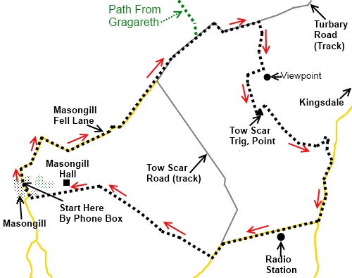
Start: As you
sit on the bench, the walk begins up the road facing you (Masongill Fell
Lane). Proceed up this tarmac road. The road is effectively a service road
for the Masongill Water Treatment works and at the works, it changes to a
stony track (Turbary Road) (SD 676723). Pick up a stone and use it to help
clarify a cairn further on (see below). There is a little alternative rough
parking here but you would then have the ascent to this point at the end of
your walk so parking in the hamlet is preferable in my opinion. Keep
straight ahead on the stony track ignoring the similar track to the right.
On the
left, you will spot a stone stile over the wall (SD 679767). Just for
information, this is the point at which the Three Men of Gragareth walk
joins this route. Ignore the stile and continue along the track, through the
metal gate and up the hill which turns right at the top of the hill. As you
turn right you will be rewarded with magnificent views of Ingleborough.
At the
turn, the path steers briefly away from the wall you have been following and
turns left. Just round this corner there may be signs of a track to the
right used by farm vehicles. Ignore this and remain on the Turbary Road
track.( If you are combining this walk with the Three Men of Gragareth,
ignore the remainder of these instructions and continue along the Turbary
Road picking up the instructions from the other walk).
The
track soon approaches the corner
of two walls and passing this corner confirms you have not turned off too
soon. You are looking for a grassy track on the right which can sometimes be
easy to miss especially if you are deep in conversation and you need to
concentrate here. About 100 yards beyond the corner of the wall, the track
dips very slightly then rises again. These changes are very slight but
important because at the bottom of the dip is the right turn for your route,
on to a grassy track (SD 685768). A small cairn has been started and if you
add the stone you have picked up earlier, you will help make the track more
obvious for others!
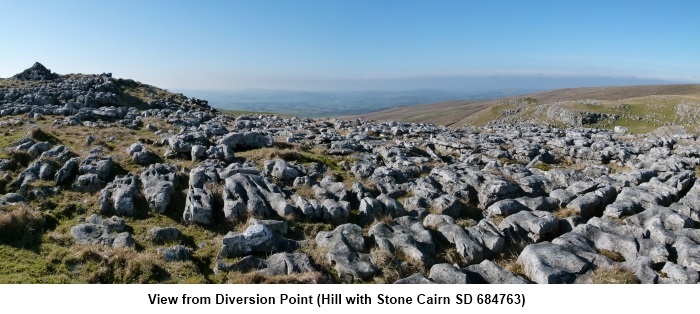
The
path descends gently and you will see a small hill on the left with a stone
cairn on the top. It is worth making a small detour to this cairn to enjoy
the view towards the Trough of Bowland across some interesting limestone
pavement (SD 684763).
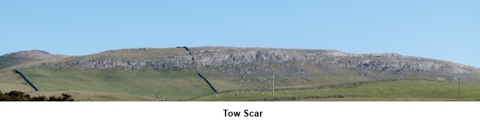
Rejoin
the path which curves round the hill you have just climbed. You should spot
the top of the Tow Scar trig. point peeping above the small hill to the
right. Watch out for a faint path on the right which goes across to the
trig. point (SD 685760).
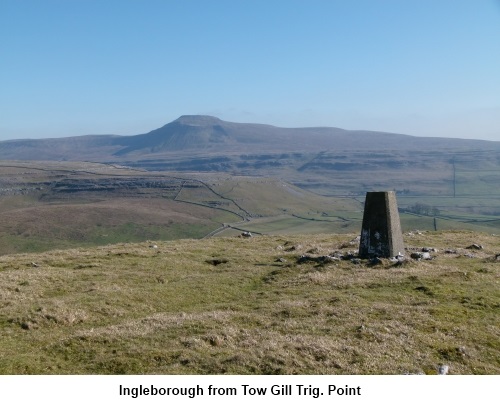
Descend
from the trig. point back to the main track. It descends gently to a gate
with Ingleton Quarry in the distance behind. Through the gate, ignore the
faint track to the left and the small gate in the wall on the right and keep
straight ahead. The path descends to the tarmac road through Kingsdale. Turn
right at the road (SD 691756).

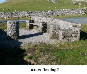
At the
next road junction, turn right again. At this junction, an impressive
resting place has been created by Thornton-in-Lonsdale Parish Council with
south facing benches and an orientation table.
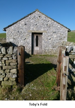
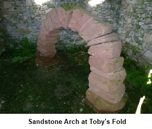
Head
along the road past the quite unusual BT communications mast. On the right
you will see a small stone building bearing a plaque “Toby’s Fold”.
This contains a red sandstone arch which was travelled by the artist Andy
Goldsworthy along ancient drovers’ roads from Scotland.
The
road turns sharp left. Just before the farm on the right, just after passing
under some power lines look out for a finger post signing “Fellside”.
(SD 681748) Cross the stile and proceed along the field with the stone wall
on your left. After a hundred yards or so, cross another stile to your left
and continue in the same direction, this time with the wall on your right.
Cross a ladder stile and descend to a gate by a stream. Cross the stream and
bear right to follow the line of the wall to a farm.
At the
farm, go through the farmyard and exit by a gateway facing you, to the left
by the barn. Keep to the right of the field and at the end cross the ladder
stile. Cross another ladder stile and at the far end of the field, turn left
to follow the hedge as indicated by a white on yellow footpath arrow (SD
671754).
Follow
the hedge to the farm and turn left on the concrete lane and
immediately right by the barn. A kissing gate confirms the route.
Cross
the large field which slopes slightly downwards and head for a stone cottage
next to the far edge of the field. You will pass the splendid Masongill Hall
on the right with its gleaming white trellis. The path passes to the left of
the cottage where there is a narrow slit stile into the road. Turn right to
return to your starting point.
If
you need to buy any hiking equipment/clothing before your trip see the Hiking
Store
All information on this
site is given in good faith and no liability is accepted in respect of any
damage, loss or injury which might result from acting on it.
|


.jpg)
.jpg)
.jpg)