|
Littondale
to Langstrothdale
|
Starting
point and OS Grid reference:

Halton
Gill in Littondale – car park (voluntary contribution) (SD 881765).
|
Ordnance
Survey Map
OL
30 Yorkshire Dales - Northern and Central areas.
Buy
this map from
List
of OS Maps
Note: If you use OS Maps on-line, you can download this route via this
link.
| |
Distance: 8.2 miles
|
Date of Walk 24
September 2014
| |
Traffic light rating:
 
(For explanation see My
Walks page)
| |


For advice on .gpx files see
My
Walks page
|

Click
the PDF logo above to give a printable version of this walk without the
photos.
|
To
view route as a dynamic Ordnance Survey map click here.
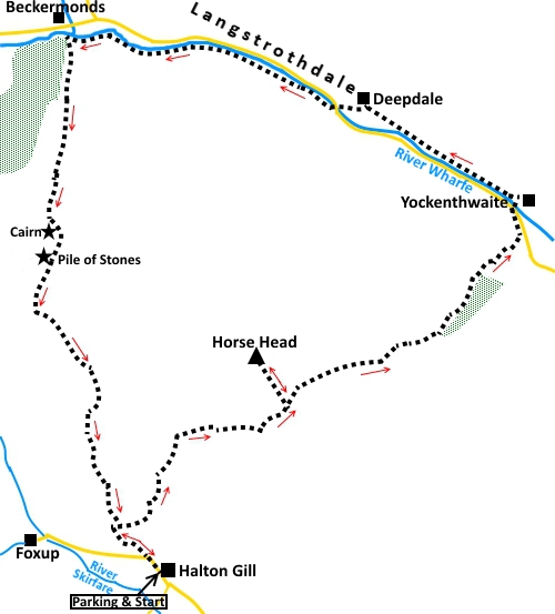
Introduction:
This walk from Littondale to
Langstrothdale gives you a chance to see the picturesque Halton Gill,
Yockenthwaite and the very pretty river walk along Langstrothdale, following
the Dalesway. You climb Horse Head at 1985 ft (605 metres). Although you
start from almost 1000 ft, in effect, by the time you have finished, you
will have ascended and descended around 2000 ft of steep slopes, which makes
this quite a hard walk. To add to the torture, there are one or two false
summit situations! Having said that, the climb is worthwhile, because from
the top, there is a stupendous view which takes in all the Three Peaks (Pen-y-ghent,
Ingleborough and
Whernside) and in the other direction,
Buckden Pike.
Halton Gill is a remote,
very attractive hamlet, with some lovely old buildings. If it has any claim
to fame, it is that it was used for filming The Woman in Black, a horror
film staring Daniel Radcliffe.
Yockenthwaite is a small
hamlet with a pretty stone bridge. The walk along the river here is lovely
and there are some useful rocks here and there for a sandwich break.
You are almost at the tiny
hamlet of Beckermonds, when you start the return ascent. This is where the
River Wharfe starts, where Oughtershaw Beck and Green Field Beck come
together.
It is worth pointing out
that on the return journey, there is quite a difference, in some places,
between where the path seems to be on the ground and where it is shown on my
OS map. If you are using GPS, my route is based on the GPS recorded track of
my actual route. Given that the path I followed passes marker cairns and
later crosses ladder stiles, I feel I got it right. In any case, this is
Access Land so you can pretty much go where you like.
The journey to Halton Gill
is almost worth it on its own. Take the B6160 from Threshfield (near
Grassington) north west towards Kettlewell. Half a mile after passing the
unmistakable overhang of Kilnsey Crag, take the left turn signposted for
Arncliffe and Litton. Stay on this road through Arncliffe, with a right/left
dogleg and keep going to Halton Gill which has a large nameplate. The car
park (voluntary contribution) is on the left as you enter the village.
Please give something – you have had a lovely ride after all!
Start:
With your back to the car park (SD 881765), turn left and walk along the
road. Just after leaving the houses round a left hand bend, leave the road
by the footpath on the right to follow the fingerpost for “Beckermonds 2½
miles” and “Yockenthwaite 3 miles”.
%20Halton%20Gill.jpg)
%20Looking%20up%20Littondale%20to%20Foxup.jpg)
%20View%20Down%20Littondale.jpg)
Follow the path as it
climbs the hill, ignoring a gate on the left which is your return route.
This is a bit of a hard slog for 1¼ miles and at the top of the hill, you
reach a wall, which runs along the ridge, with a gate. To visit the trig
point (SD 887780), do not go through the gate but turn left to follow the
wall, on a faint path. After “bagging” the trig point, return to this
gate and go through it.
%20Horse%20Head.jpg)
%20View%20to%20Buckden%20Pike.jpg)
Follow the obvious path as
it descends into Langstrothdale, meeting the road at Yockenthwaite (SD
905789). Turn left, then right over the bridge.
%20Descent%20to%20Langstrothdale.jpg)
%20Bridge%20at%20Yockenthwaite.jpg)
According to the map, the
Right of Way curves round to the farm then back but in practice, once over
the bridge, you might just as well follow the wall on the left briefly (no
more than 30/40 yards), then turn left on the track.
Follow the track (part of
the Dalesway) as it runs parallel with the river. You soon pass an old lime
kiln and at SD 900794, you pass to the left of an ancient stone circle or
base of an old cairn, no-one seems quite sure but it is believed to be
Bronze Age.
%20Old%20limekiln.jpg)
%20View%20along%20the%20River%20Wharfe%20at%20Yockenthwaite.jpg)
After following the river
for about three quarters of a mile, and after passing through a walkers’
gate, on to a broad stony track, turn left to follow the fingerpost for
Beckermonds.
The track leads down to the
road. Cross the bridge (SD 893797) and turn right to follow the fingerpost
for Dalesway and Beckermonds.
%20Waterfalls%20on%20the%20Wharfe.jpg)
You pass New House Cottage.
Follow the track/path by
the river, until you get almost opposite Beckermonds, a white painted
farmhouse. Here, climb up a short banking and through a gate. Not far ahead
is a three way fingerpost (SD 874802). Turn left to follow the fingerpost
for “Halton Gill”.
%20Looking%20down%20on%20Beckermonds.jpg)
The path climbing the hill
is faint but you can trace it with care. Unfortunately, there are no obvious
landmarks I can give at this stage, other than the top! It is something of a
lung bursting climb. There is a clear course of a stream (which was dry when
I did the walk) and you need to keep to the right of this depression.
From here on, the path on
the ground bears little relation to its position on the OS map, as mentioned
in the introduction.
At SD 874789, there is a
small stone cairn, which will confirm you are on the right route. A little
further on, at SD 873787, is a larger rather strange shaped cairn, looking
almost like a short stretch of wall as you approach, indicated as “Pile of
Stones” on the OS map. By this point, you can see the gate on the horizon
which is your aiming point (SD 873786).
%20The%20pile%20of%20stones.jpg)
From the gate, the path
goes straight ahead at first, then curves to the left. You cross a collapsed
stone wall.
The path is marked with
intermittent posts. It leads to a ladder stile (SD 875779). Cross this and
keep straight ahead on the obvious path. Not far after the ladder stile you
meet a crossing path but keep straight on.
%20Ingleborough.jpg)
Cross a second ladder
stile.
The path drops down to a
five bar gate. Go through this and turn right here. At the next gate you
should recognise this as your outward route. Retrace your steps to the
parking.
If you need to buy any
hiking equipment/clothing before your trip see the Hiking
Store
All information on this
site is given in good faith and no liability is accepted in respect of any
damage, loss or injury which might result from acting on it.
|


.jpg)
.jpg)
.jpg)