|
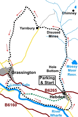
Hebden
to Grassington via the Mines
Starting point and OS Grid reference:

Road
parking in Hebden village outside the Methodist Chapel
(SE 027630)
|
Ordnance Survey Map
OL2
Yorkshire Dales – Southern and Western.
Buy
this map from
List
of OS Maps
Note: If you use OS Maps on-line, you can download this route via this
link.
| |
Distance: 8 miles
|
Date of Walk: 8
September 2014
| |
Ascent:
Descent:
See Walking Time Calculator
|
982ft (299m)
978ft (298m)
| |
Traffic
light rating:

(For explanation see My
Walks page)
| |


For advice on .gpx files see
My Walks page
|

Click
the PDF logo above to give a printable version of this walk without the
photos.
|
To
view route as a dynamic Ordnance Survey map click here.
Introduction:
This walk from Hebden could equally
be started from Grassington, as it is circular but parking in Hebden is
free! Also, Grassington provides a great lunch stop, with lots of choice - I
particularly like The Foresters Arms. Also, in this direction, the hard work
(such as there is) happens first, leaving a leisurely and attractive post
lunch walk back from Grassington along the River Wharfe, passing Linton
Falls. There is a slightly shorter route back to Hebden after seeing Linton
Falls, marked in green on the sketch map but it seems a shame to miss the
riverside walk and the somewhat unique suspension bridge.
The route passes through
some of the old lead mining area with interesting relics to see. The
Grassington area has been a centre for lead mining since at least the 1600s
and if you look at the 1:25000 Ordnance Survey map (OL2 Yorkshire Dales –
Southern and Western) to the north of Grassington, you will see a large area
with mining notations. This walk only covers a fraction of what is there to
see. My Grassington
Moor, Lead Mines and Mossdale Scar walk takes you through a major old
mining area, high on the moors.
Over the history of the
mining here, dams and watercourses expanded until at one point there was a
network spreading over eleven kilometres. Eleven waterwheels sites have been
identified and a couple of them are passed on this walk.
Maximum prosperity arrived
between 1821 and 1861then a steady decline set in, as the mines became
exhausted and foreign imports grew. The last activity, to recover ore from
spoil heaps, ended in 1963.
There are a number of
information boards which tell you something about the mining.
A word of warning – stay
on the obvious tracks. There are unmarked mine shafts on these moors and not
even any guarantee all the locations are known. Some may have a fragile
covering and be invisible until ……………!
As you approach Yarnbury,
you could take the opportunity to visit Yarnbury
Henge. This is clearly
shown on the OS map, south of Yarnbury.
Refreshments are available
in Grassington at a variety of pubs/cafes, at the Clarendon Hotel in Hebden
and at The Old School Tea Rooms also in Hebden.
The walk starts outside the
Methodist chapel in the small village of Hebden where the road is wide
enough to park and there are benches convenient for boot changing. Hebden is
on the B6265 between Grassington and Pately Bridge. Turn south into the
village off this road and the chapel is on the right after a couple of
hundred yards
Start:
Facing the chapel (SE 027630), turn right and walk through the village to the B6265.
Cross and stay on the main tarmac lane straight ahead for just over half a
mile.
%20Bolton%20Haw%20Crags.jpg)
As the track bends left at
Hole Bottom, by some stone cottages (SE 024641) (Jerry and Ben’s Holiday
Cottages at the time of writing), go straight ahead in front of the cottages
following the public bridleway sign for “Yarnbury 1½ miles.
%20Bridge%20near%20Hole%20Bottom.jpg)
You are now on a broad
stony track which soon crosses a bridge over Hebden Beck, to follow the
right hand bank. You soon pass evidence of mining, not least an old shaft
(now a watercourse) and a waterwheel pit). Stay on the track, through a gate
with a sign telling you there are stepping stones in 100 yards. The track
forks, take the left fork.
%20Route%20along%20Hebden%20Beck.jpg)
%20Old%20mine%20building%20ruins.jpg)
%20Waterwheel%20pit.jpg)
%20Stepping%20stones%20over%20Hebden%20Beck.jpg)
Stay close to the right
hand bank of the beck until you come to the stepping stones (three large
rectangular blocks). Cross the beck then follow the left hand beck. The
track soon crosses the beck again but stick to the narrower path along the
left hand bank which rejoins the main track after it crosses the beck yet
again, further on.
%20Loss%20Gill%20Bank.jpg)
Keep to the main track,
close to the beck, as it passes the old spoil heaps, then follow it as it
swings left (SE 025658), away from the stream, ignoring a fork off to the
right. You pass an old lime kiln. As the track climbs, look back, to see the
huge chimney on Grassington Moor, a remnant of a smelt mill and a well known
local landmark.
%20Old%20Lime%20Kiln.jpg)
%20Smelt%20Mill%20Chimney%20Grassington%20Moor.jpg)
As the track starts to
level out, turn right through a gateway marked with a public bridleway sign.
You pass some old spoil
heaps and remains of old mine buildings, which are Scheduled
Ancient Monuments and it is worth a diversion to explore these and
read the information boards.
%20Old%20waterwheel%20building.jpg)
%20Mine%20entrance.jpg)
%20Remains%20of%20shafts.jpg)
The route continues through
the un-gated gateway on the unmistakable track. On meeting another broad
track (SE 020659), turn left to Yarnbury.
At Yarnbury, take the track
to its right, alongside the house, following a fingerpost (which is on the
opposite side of the main track) “Byciffe Road 2 miles”. At the garages
belonging to the house, the route passes to the right of the fence. It soon
branches right on, a grassy path, marked with yellow topped posts.
The path curves right,
through some old grass covered spoil heaps to a walkers’ gate (SE 014661).
Through this, turn left on a broad track which you follow for half a mile.
There are good views here across Wharfedale and right, across Grassington
Moor.
%20View%20back%20to%20Yarnbury.jpg)
%20View%20North%20Over%20Grassington%20Moor.jpg)
The walled track comes to
an end in more open pasture. Follow the wall as it curves left and cross the
ladder stile in the corner (SE 010668), to follow the obvious path down to a
stepped slit stile in the wall. This is a rather awkward stile as the stones
on the far side slope away from you. It will be fun in wet/icy weather!
%20View%20over%20Wharfedale.jpg)
The route to Grassington is
pretty obvious, via a series of stiles. At a crossroads of tracks, go
straight on.
Eventually, the path drops
down to a wooden stile by a gate. Cross this and after a short section of
broad track, turn left.
You arrive at a road
junction where a road sign tells you that you have been walking down Back
Lane. Turn left and at the next junction, turn right for Grassington Centre.
%20Grassington%20Centre.jpg)
Sample some of the delights
of Grassington, then proceed downhill to the A6265 and turn left. Cross the
road at the main car park, then, bear left across the car park, to the far
corner, where you will fine the narrow path down to Linton Falls.
%20Linton%20Falls.jpg)
Do not cross the footbridge
but turn left on the footpath (SE 001634), just before it.
It is now a matter of
following the river footpath to Hebden. It does briefly exit into a road via
a gated step stile (SE 006634). Turn right past the fish farm to rejoin the
path by the river. Pretty Linton Church is visible across the river and the
alternative path to Hebden soon follows, should you want it.
%20River%20Wharfe.jpg)
Otherwise, stay on the
riverbank until, at Hebden suspension footbridge (built by the local
blacksmith William Bell and opened in 1885), a path turns off to the left
(SE 026624). Take this to the road and turn right. Go over the river bridge
then turn left in the direction of the fingerpost for “Hebden
½ mile”. The path passes between the two bungalows (SE 027624).
%20Hebden%20suspension%20bridge.jpg)
Keep straight ahead at the
fish farm (another one) crossing the stream by the single slab bridge. The
path now follows the left hand bank of Hebden Beck before rising to the road
opposite the Methodist Chapel where you started.
If you need to buy any
hiking equipment/clothing before your trip see the Hiking
Store
All information on this
site is given in good faith and no liability is accepted in respect of any
damage, loss or injury which might result from acting on it.
|


.jpg)
.jpg)
.jpg)