|
Grassington Moor Lead Mines and Mossdale Scar
Starting point and OS Grid reference:

Rough,
free parking at Yarnbury (SE 015659)
|
Ordnance Survey Map
OL2 – Yorkshire Dales, Southern and Western.
Buy
this map from
List
of OS Maps
Note: If you use OS Maps on-line, you can download this route via this
link.
| |
Distance: 7.1
miles
|
Date of Walk: 21 September 2014
| |
Ascent:
Descent:
See Walking Time Calculator
|
850ft (259m)
848ft (258m)
| |
Traffic
light rating:

(For explanation see My
Walks page)
| |


For advice on .gpx files see
My Walks page
|

Click
the PDF logo above to give a printable version of this walk without the
photos.
|
To
view route as a dynamic Ordnance Survey map click here.
Introduction:
Having recently compiled the walk
from Hebden via the lead mines, I decided to return to the area to take a
closer look at some of the aftermath of the mining activity on Grassington
Moor. There is a defined lead mining trail but I did not set out to
replicate this. Also, I wanted to see Mossdale Scar where Mossdale Beck
disappears dramatically beneath the Scar.
This walk is very easy to follow, being on
clear and wide well defined tracks for almost its entirety.
It could be combined with the walk from
Hebden if you wanted a much longer walk.
As is obvious if you look at the OS map, the
lead mining area to the north of Grassington is vast. Its heyday was between
1821 and 1861 then a steady decline set in, as the mines became exhausted
and cheaper foreign imports grew. The last activity, to recover ore from
spoil heaps, ended in 1963. My main targets for the walk were to see the
smelt mill chimney, its extensive flue and the curious circular structure
which you can see across the fells. This turned out to be the remains of a
grinding mill.
The walk across to Mossdale Scar was through
something of a wilderness of spoil heaps although there are good long
distance views.
Mossdale Scar is a limestone cliff and
beneath this, Mossdale Beck gurgles as it disappears into caverns beneath.
The caverns are rather notorious in that on 24 June 1967, a group of six
cavers became trapped and five were killed, despite extensive efforts to
rescue them. Their remains still lie entombed in the cave system. There is a
cairn on the hill above which marks their position below.
The walk starts from Yarnbury, high above
Grassington. To get there, head north from Grassington centre, up Main
Street (to the left of the cobbled car parking area). At the top of Main
Street, keep straight ahead, to the left of the Town Hall (with the clock).
This is Moor Lane. Follow it until the tarmac runs out at Yarnbury, where
there is an entrance on the right to the rough parking area.
There are no refreshment facilities en route
but some rocks on which you can perch at Mossdale Scar, for a picnic.
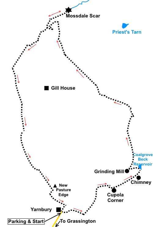
Start:
From the parking at Yarnbury (SE 015659), continue on the main track away
from the entrance and when it splits, go left.
%20Stile%20to%20Grassington%20moor.jpg)
%20Crossing%20dry%20beck.jpg)
You will soon see a black arrow on a post on
the right. Leave the main track and follow this arrow. You arrive at the
Cupola Smelt Mill (SE 026664), number 12 on the Lead Mining Trail. An
information board tells you about it.
Continue to follow the Lead Mining Trail
which follows the course of the flue to the chimney. You can see into the
flue at various places. Spare a thought for the poor souls who had to sweep
this so that every last drop of lead could be extracted from the flue gas
deposits. One suspects they did not reach a ripe old age!
%20Flue.jpg)
%20Paved%20path%20to%20chimney.jpg)
The clear path leads directly to the chimney
(SE 030666), including a paved section. At the chimney, be sure to admire
the view up Wharfedale behind you. The chimney was saved by the Earby Mines
Research Group through restoration in 1966 and 1971.
%20View%20SW.jpg)
%20Smelt%20mill%20chimney.jpg)
From the chimney, continue on the path ahead,
in the same direction as you arrived, heading for the spoil heaps. Just past
the spoil heaps is Coalgrove Beck reservoir (No 16). This was used to
provide water to drive the High Grinding Mill and High Winding House. You
cannot see the reservoir until you get to it.
%20Coalgrove%20Beck%20Reservoir.jpg)
Follow the path along the left hand side of
the reservoir. Just before the end of the reservoir, turn left between the
spoil heaps heading for the round stone construction ahead (the High
Grinding Mill).
%20Remains%20of%20High%20Grinding%20Mill.jpg)
From the High Grinding Mill (SE 028667), with
it behind you, turn left to follow the main track. At a crossroads of
tracks, keep straight on (SE 029668). You now follow this clear track for
2.5 miles.
At SE 024681, pass a cairn on the right of
the track where the track curves sharply right. This is marked on the OS
map.
%20Cairn%20at%20SE%20024681.jpg)
As you approach Mossdale, note the hill Great
Whernside on the horizon.
%20Approaching%20Mossdale%20with%20Great%20Whernside.jpg)
On a sharp right hand bend, having been
walking through a gritstone landscape, you are suddenly faced with an
outcrop of limestone. The track joins another in the valley bottom (SE
013695). Turn right here for 1/3 mile for Mossdale
Scar. There are some convenient rocks here for a picnic stop.
%20Limestone%20Outcrop.jpg)
%20Mossdale%20Scar.jpg)
%20Mossdale%20beck%20disappearing.jpg)
After inspecting Mossdale Scar (SE 016698)
and the unusual disappearance of Mossdale Beck, retrace your steps, passing
a stone sheepfold (SE 016697) and the track on the left down which you came.
%20Sheepfold.jpg)
From this junction, stay on the main track
for three quarters of a mile. Shortly after passing through a metal gate, look out for a
grassy footpath on the left marked with a small stone cairn and turn off
here (SE 006687). It is easy to be seduced by the continuing track ahead if
you are not concentrating!
The grassy footpath is pretty clear (watch
out for various lengths of old fencing wire which might trip you up) and
when it arrives at two gates side by side, go through the left gate into a
walled track. After 250 yards or so, the walled track opens into a large
field, through a gate. The route is over to the right, following the line of
the wall. Ignore any routes off via stiles to the right.
Continue to the end of the field and go
through a gate on to another section of walled track. Follow this to
Yarnbury and at the junction with the track/road, turn right back to the car
park. Note the little low stone parapet to the left. If you walk round the
other side of it (do not
jump over it - you will find a nasty drop!), you will see this is the
entrance to Barretts Incline, built in 1828, to link with shafts below. An
information board explains.
%20Approaching%20Yarnbury.jpg)
%20Entrance%20to%20Barretts%20incline.jpg)
If you need to buy any
hiking equipment/clothing before your trip see the Hiking
Store
All information on this
site is given in good faith and no liability is accepted in respect of any
damage, loss or injury which might result from acting on it.
|


.jpg)
.jpg)
.jpg)