
|
|
|
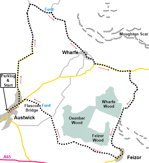
To view route as a dynamic Ordnance Survey map click here. Introduction: I selected this route from Austwick to Feizor via Wharfe, after a spell when availability to walk and decent weather failed to coincide for a while and there came a window of opportunity. This was after a spell of very wet weather, even up to and including the morning of the day in question. However, the forecasts promised a good day after lunch. So, I was looking for a route for a quick afternoon walk but avoiding crossing fields, which I expected to be very muddy. Sometimes walking on mainly tracks and lanes can be a little boring but what I did not expect from this route, or in part had forgotten, was quite the number of fantastic views, including to Ingleborough and Pen y ghent and the dramatic scars, even though I had walked some of the route before. The walk is a very easy route, both in terms of navigation and underfoot. In drier weather, it could comfortably be undertaken in trainers. There are no stiles and only one gate! The walk starts in Austwick, a quite large but attractive old village, mostly built from stone, with some buildings dating back to the 16th century. It is bordered to the north by some impressive limestone scars, notably Robin Proctor’s Scar, above which sit the Norber Erratics, visited on my Crummackdale walk. The Norber Erratics are a group of sandstone boulders which were transported from their “proper” place about a kilometre away by glaciers about 13 to15,000 years ago and left perched (in some cases dramatically) on top of limestone rocks. Wharfe is a tiny hamlet and the only settlement in Crummackdale. The great limestone Moughton Scar is its backdrop. Feizor too is a small hamlet with its own limestone backdrop of Pot Scar and Smearset Scar. It has become well known for Elaine’s Tea Rooms which is open every day and very popular. Close by is Oxenber Wood, a Site of Special Scientific Interest (SSSI), which gives a fine display of flowers in the spring. To get to Austwick, turn north off the A65, about four and a half miles west of Settle. It is signposted. I parked by the village green, opposite the Game Cock Inn, from where the walk is described. Warning: I was informed on 17 April 2026 that the clapper bridge referred to below and pictured in the photo is gone, presumably swept away in a flood. The smaller bridge to the rear of the photo is still there to enable the stream to be crossed but it involves a precarious route along the river bank, which can be slippery and muddy. Given the historic nature of the bridge, I expect it will be restored at some point. If/when it is, I would appreciate being advised to keep the walk up to date. Start: Facing the Game Cock Inn (SD 768685), turn right along the main street for about three hundred yards and turn left along Townhead Lane. Stay on this lane, ignoring any turns off, for about one and a half miles. It is tarmac for a good distance, then becomes a more stony surface and becomes Crummack Lane.
At SD 772700 pass a public bridleway finger post for “Thieves Moss 21/3 miles”. Just under half a mile after the fingerpost, reach a junction of tracks with a sign indicating that the way ahead is barred to vehicles. Turn right here, following the fingerpost for “Wharfe 1¼ miles” (SD 772707). This is White Stone Lane, although there is no name sign. A quarter of a mile further on, there is a clapper bridge to enable you to cross Austwick Beck. If you look behind the wall by the clapper bridge, there is a pleasant bench which overlooks the Wash Dub (“dub” meaning pool). In the days before modern sheep dips, the beck was dammed and the sheep herded through the water and scrubbed, to clean them. There is an interpretation panel to tell you all about it. Continue on the obvious route to the hamlet of Wharfe.
At the main junction of tracks in the centre of the hamlet, turn left, passing a stone bench and a stile on the left. Stay on this track until, after a sharp right hand curve, then a left, you join the road (SD 784695). Turn left along the road. Note the impressive Moughton Scar, above you to the left.
Walk along the road for half a mile, passing White House and Far End. About a hundred and seventy five yards after Far End, turn right on a broad track following the public bridleway fingerpost for “Feizor 1¼ miles” (SD 792693). At the first farm (Lower Bark House) follow the track straight through the yard, shortly after which is a fingerpost confirming that Feizor is one mile ahead. At the next farm (High Bark Farm) follow the track as it curves left climbing slightly. There are good views here to Ingleborough and Pen y ghent.
On arrival in Feizor, follow the road through its centre and around the bend. Look out for a fingerpost on the right, to the right of a large barn, for “Austwick 1¾ miles” (Hale lane) (SD 789676) and follow this. Be sure to look behind you for the view of Feizor with Pot Scar and Smearset Scar behind it.
Arrive at a junction of several tracks and take the narrower path following the public bridleway fingerpost for “Austwick” (SD 776684). Shortly after this, cross Flascoe Bridge alongside the ford over Austwick Beck. On arriving at the road in Austwick, turn left back to the start. If you need to buy any hiking equipment/clothing before your trip see the Hiking Store All information on this site is given in good faith and no liability is accepted in respect of any damage, loss or injury which might result from acting on it.
| | |||||||||||||||||

.jpg)
.jpg)
.jpg)
%20Robin%20Proctor's%20Scar.jpg)
%20Looking%20East%20from%20Crummack%20Lane.jpg)
%20Clapper%20bridge%20at%20the%20ford%20on%20Austwick%20Beck.jpg)
%20The%20Wash%20Dub.jpg)
%20Path%20to%20Wharfe%20and%20Moughton%20Scar.jpg)
%20View%20south%20near%20Wharfe.jpg)
%20Arriving%20at%20Wharfe.jpg)
%20View%20to%20Studrigg%20Scar.jpg)
%20Moughton%20Scar.jpg)
%20View%20to%20Ingleborough.jpg)
%20Pen%20y%20ghent%20from%20Lower%20Bark%20House.jpg)
%20Descending%20to%20Feizor.jpg)
%20Looking%20back%20up%20the%20track%20to%20Feizor.jpg)
%20Approaching%20Feizor.jpg)
%20Feizor%20with%20Smearset%20Scar.jpg)
%20Flascoe%20Bridge.jpg)