|
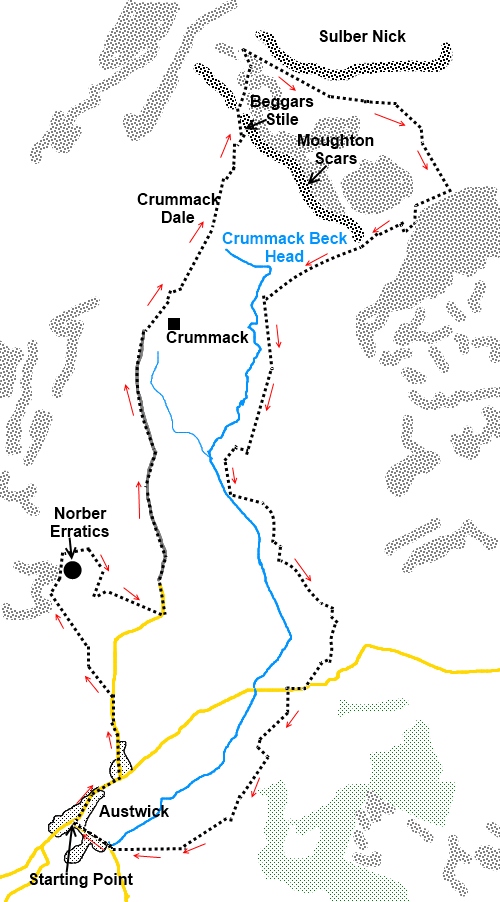
Crummack
Dale and the Norber Erratics
Starting point and OS Grid reference: 
Village
green Austwick (SD 767684) – on street parking
|
Ordnance Survey Map
OL2
Yorkshire Dales Southern and Western.
Buy
this map from
List
of OS Maps
Note: If you use OS Maps on-line, you can download this route via this
link.
| |
Distance: 9 miles
|
Date of Walk: 23 November 2008
| |
Ascent:
Descent:
See Walking Time Calculator
|
1186ft (362m)
1187ft (362m)
| |
Traffic
light rating: 
(For explanation see My
Walks page)
| |


For advice on .gpx files see
My Walks page
|

Click
the PDF logo above to give a printable version of this walk without the
photos.
|
To
view route as a dynamic Ordnance Survey map click here.
Introduction:
This is an easy walk with very little
hard work in one of the lesser known Yorkshire Dales. You could well meet
no-one else on this walk. It takes you across some classic limestone scenery
and also gives you an opportunity to visit the Norber Erratics, a group of
sandstone boulders which were transported from their “proper” place
about a kilometre away by glaciers about 13 to15,000 years ago and left
perched (in some cases dramatically) on top of limestone rocks.
The walk starts in the
lovely classic Dales village of Austwick
and for the sake of a common reference point begins at the triangular
village green with its restored “cross”.
Parking is on the street. To get to Austwick, turn north off the A65 between
Long Preston and Ingleton where signposted.
Start:
From the village green in
Auswick (SD
767684) with the church behind you, walk along the main street in the
direction of the signpost for Horton 5 miles. At Townhead Lane (SD 770687),
turn left and continue for 5/600 yards until it meets broad tracks off to
the right and left at a “crossroads” (SD 770692).
%20Centre%20of%20Austwick.jpg)
Turn left
and almost immediately right on to a footpath over a ladder stile.
Cross the field to the wall on the left and follow it round and go over the
stile in the corner. As you approach the rocky bluff, turn right then left
at a 4 way fingerpost (SD 767697) to see the Norber Erratics. There is a
slight climb and you will see the Erratics scattered around and you need to
wander around them to see some of the more interesting ones.
%20Robin%20Proctors%20Scar.jpg)
%20Norber%20Erratic%20-%201.jpg)
%20Norber%20Erratic%20-%202.jpg)
%20Nappa%20Scar.jpg) When you have finished,
there is a broad obvious grassy track which runs more or less through the
middle heading more or less easterly and slightly downhill back towards
Crummack Dale. Follow this to the stone wall then turn right. Walk along the
side of the wall until you come to a stone step stile (SD 768698). Cross
this and follow the footpath going slightly left passing under the cliffs of
Nappa Scars. On reaching the tarmac road over a stile, turn left (SD
772697).
When you have finished,
there is a broad obvious grassy track which runs more or less through the
middle heading more or less easterly and slightly downhill back towards
Crummack Dale. Follow this to the stone wall then turn right. Walk along the
side of the wall until you come to a stone step stile (SD 768698). Cross
this and follow the footpath going slightly left passing under the cliffs of
Nappa Scars. On reaching the tarmac road over a stile, turn left (SD
772697).
The tarmac road becomes a
stony track. Remain on this passing a bridleway sign for Thieves Moss 21/3
miles. Ignore a turning on the right to Wharfe and stay on the main track.
Eventually, the main track
turns right over a cattle grid with a no public access sign and at this
point, branch off the track straight ahead and through the gate which has a
public footpath yellow marker next to it (SD 774717).
Keep straight ahead passing
a bridleway sign for Horton in Ribblesdale. Ahead of you are the limestone
cliffs of Moughton Scars. The path forks. Take the right fork heading for
the ladder stile (marked as Beggars Stile on the OS map (SD 777726).
%20Crummack%20Dale.jpg)
%20Pen-y-Ghent%20from%20Crummack%20Dale.jpg)
%20Moughton%20Scars.jpg)
Climb the stile and on
reaching the top of Moughton Scars, fork left and stay on the main path
between the areas of limestone pavement heading roughly north heading for
the limestone cliffs ahead of you. Ingleborough comes into view on the left.
%20Approach%20to%20Thieves%20Moss.jpg)
As you approach the foot of
the cliffs, this is the area known as Thieves Moss. Turn right here along a
faint path walking more or less
parallel with the cliffs (SD 777731). After about a third of a mile, the
path starts to move away from the cliffs heading in a south easterly
direction between limestone pavement and past a stone cairn. It arrives at a
finger post at a ladder stile (SD 790722). Do not cross the stile but turn
right signposted Austwick 2¾ miles. You pass a row of grouse butts.
%20Moughton%20Scars%20from%20Esatern%20End.jpg) As you reach the south
eastern end of Moughton Scars, turn right where a rectangular depression
looks as though it has been cut into the rocky ground (SD
787720). Descend, go through a gate (SD 784719) and follow the grassy walled
lane. Stay on this walled lane until you reach another broad track (SD
779716). Turn left and stay on this track ignoring any turns off.
As you reach the south
eastern end of Moughton Scars, turn right where a rectangular depression
looks as though it has been cut into the rocky ground (SD
787720). Descend, go through a gate (SD 784719) and follow the grassy walled
lane. Stay on this walled lane until you reach another broad track (SD
779716). Turn left and stay on this track ignoring any turns off.
The track exits into the
hamlet of Wharfe, a place you might never know existed as no road signs seem
to point to it. As it does, turn left then immediately right and follow it
down to the road where you turn right (SD 781792).
Turn left at the entrance
to Woodend Farm signposted Feizor 1¾ miles and at the farm, turn right.
At
the next sign, ignore the route
signed Austwick and follow the Pennine Way sign more or less straight ahead.
When the track exits into a
road, turn right back into Austwick.
If you need to buy any hiking
equipment/clothing before your trip see the Hiking
Store
All information on this
site is given in good faith and no liability is accepted in respect of any
damage, loss or injury which might result from acting on it.
|


.jpg)
.jpg)
.jpg)