
|
|
|
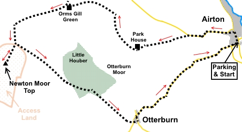
To view route as a dynamic Ordnance Survey map click here. Introduction: This circular walk from Airton to Newton Moor Top, returning via Otterburn is a very easy, relatively level walk but one which still offers some fine views, especially from Newton Moor Top. Even on the somewhat mixed weather day when I did the walk, the short climb to the top was well worth it. Airton unsurprisingly gets its name because it stands alongside the River Aire which provided power for a large mill, now converted into apartments and with listed status. Take a short diversion down to the river to have a look before starting the walk. The village is a popular starting point for walkers, the most popular route no doubt being along the river to Malham. Stay away from the crowds on this peaceful walk. Newton Moor Top provides panoramic 360° view across Ribblesdale to Pendle Hill and across the Dales to Ingleborough. Newton Moor Top is Access Land so you can make your own way up it. However there was a direct obviously trodden route when I visited. An alternative route to see this hill can be seen on my Long Preston, Newton Moor Top and Scaleber Force route. Otterburn is a tranquil pretty hamlet, with a stream running through it. The village green has an imposing stand of trees. The bridge is late 18th or early 19th Century and Grade II listed. There is some road walking, notably one and a half miles from Otterburn to Airton but it is a pleasant walk with little traffic. The walk starts from the village green at Airton, where there is a handy bench for putting boots on. The easiest route to describe to get there is to turn right off the A65, just east of Gargrave and follow the signs. There are no facilities en route. An unusual wide stile just before/after climbing Newton Moor Top provides a possible picnic stop, though you might have to move, in the remote chance of anyone wanting to cross. Note, after wet weather you will encounter a lot of mud on this walk, when gaiters are strongly recommended! Start: From the village green facing Airton Manor (by the seat) (SD 803592), turn right along the road, following the direction of the road sign for Kirkby Malham and Malham.
After less than two hundred yards, fork left along the road indicated by a restricted width access sign and at the next junction, turn left. After half a mile, turn off the road on to a footpath by some sheep pens, indicated by a fingerpost for “Park House ¾ mile” (SD 893593). Bear right at about 45° to the road. At the far side of the field, go through a gate to the right of a small stone barn (Dowber Laithe). Beyond the gate, keep to the right of the small copse of trees and keep to the bottom of the slope which leads to the high point of the field. At the end of the field, cross a stone step style, to the left of a gateway. In the next field, go through the gateway to the left of the barn, then bear left. Follow the left boundary of the field and exit into a broad track by a white painted farmhouse (Park House) (SD 883590). Turn right along the track.
The track peters out fairly quickly. Keep just to the right of the brow of the hill. Continue towards a wall where there were two gates although one was merely covering a section of collapsed wall and may not be permanent. Go through the “proper” gate. Do not go through the gate into the narrow fenced section. Head for a gate in the top right hand corner of the field where you join a broad track. Turn left (SD 879597). Follow this track for three quarters of a mile, passing the farmhouse at Orms Gill Green, where there is an old lime kiln. About a hundred and fifty yards after the farm, as the track curves right, turn left through a gate. (don’t be seduced by the nice easy track and lack of concentration as I initially was!).
The footpath is rather indistinct. It drops down into a little valley and climbs the other side across roughly the middle of the field. Slightly to the right of centre of the far side of the field, cross a stile and continue straight ahead, towards the far left corner of the next field. Here there is a recent plantation of trees, though none seemed yet to be out of their protective tubes when I passed. Keep to the right of this, crossing a small stream. Ahead is a narrow wood. Head for the left of this, where there is a narrow wooden footbridge (SD 861595). Cross this, then, ford a second (shallow) stream. Beyond this, follow the obvious footpath as it curves left to follow the wall.
When the wall ends, cross a ladder stile, joining a broad track. There is a two way fingerpost. Turn left for “Otterburn 1½ miles”. A few yards along the track is a walkers’ gate which was locked but next to it is a peculiar stile arrangement. Not only did this provide a lunch stop but also provides the way in to the Access Land and Newton Moor Top. Just head upwards (there was a clearly trodden path when I visited) until the trig. point appears.
Return to the broad track and head for Otterburn. Go through a gateway then follow a left hand fingerpost for “Otterburn”. The route is parallel with the wall on the left until you reach another gate. The route ahead is clear and gently descends to a more definite track through the woodland (Dacre Lane).
At the road, turn left (SD 883576) into Otterburn. There, cross the river bridge and continue along the road back to Airton, about one and a half miles.
If you need to buy any hiking equipment/clothing before your trip see the Hiking Store All information on this site is given in good faith and no liability is accepted in respect of any damage, loss or injury which might result from acting on it.
| | |||||||||||||||||

.jpg)
.jpg)
.jpg)
%20Centre%20of%20Airton.jpg)
%20Remains%20of%20Stocks%20at%20Airton.jpg)
%20Otterburn%20Beck.jpg)
%20Old%20lime%20kiln.jpg)
%20Footbridge.jpg)
%20Trig%20point%20at%20Newton%20Moor%20Top.jpg)
%20View%20west%20from%20Newton%20Moor%20Top.jpg)
%20View%20North%20from%20Newton%20Moor%20Top.jpg)
%20Approaching%20start%20of%20Dacre%20Lane.jpg)
%20View%20SW%20from%20Dacre%20Lane.jpg)
%20View%20NE%20fron%20Dacre%20Lane.jpg)
%20Approaching%20Otterburn.jpg)
%20Village%20green%20Otterburn.jpg)
%20Bridge%20at%20Otterburn.jpg)