|
Long Preston, Newton Moor
Top and Scaleber Force
Starting point and OS Grid reference: 
On
road parking outside the Maypole Inn, Long Preston (SD 834523)
|
Ordnance Survey Map
OL2
Yorkshire Dales – Southern and Western Areas.
Buy
this map from
List
of OS Maps
Note: If you use OS Maps on-line, you can download this route via this
link.
| |
Distance: 9.7
miles
|
Date of Walk: 18 November 2011
| |
Ascent:
Descent:
See Walking Time Calculator
|
1144ft (349m)
1147ft (350m)
| |
Traffic
light rating: 
(For explanation see My
Walks page)
| |


For advice on .gpx files see
My Walks page
|

Click
the PDF logo above to give a printable version of this walk without the
photos.
|
To
view route as a dynamic Ordnance Survey map click here.
Introduction:
Long Preston is an attractive
Yorkshire Dales village which has the misfortune to be bisected by the
A65. At least it makes it easy to find! It sits between Gargrave and Settle.
It has a train station too.
This walk is almost too
easy being for the most part on broad clear tracks. Although it is almost 10
miles long, it is unlikely you will actually feel you have covered that
distance. The walk includes an “optional extra” of half a mile each way
to the trig. point at Newton Moor Top which is a surprisingly little visited
spot considering the panoramic view it affords. You get to view the
impressive Scaleber Force waterfall and some attractive limestone scenery at
the rear of Settle. Almost throughout the walk, there are excellent views
over Ribblesdale to Pendle
Hill. I do however have to appologise for the
photos as it was a very dull overcast day when I did this walk.
Refreshments are available
at pubs in Long Preston, not least the Maypole Inn on the village green from
where the walk starts.
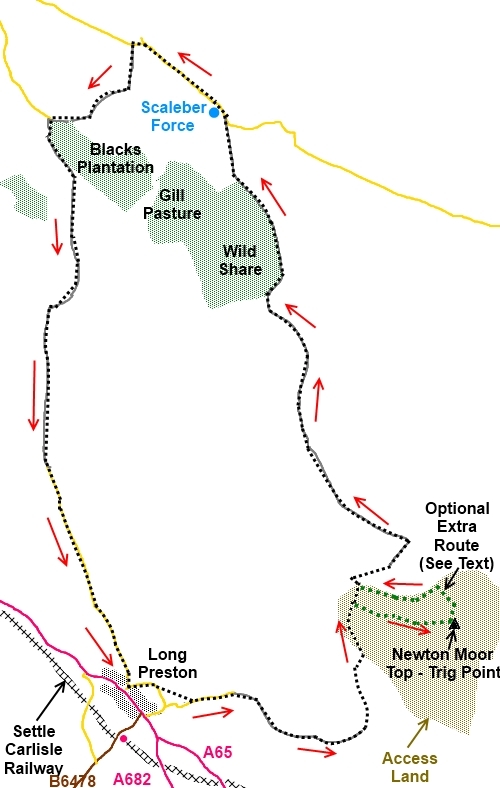
Start:
With your back to the A65, proceed straight ahead. When the road forks, bear
right along School Lane. Follow the road round past the school ignoring the
first path off to the left, then take the narrow walled footpath with the
fingerpost for New House Lane (SD 837583) (you will be within sight of the
village church at this point).
%20St%20Marys%20Church%20Long%20Preston.jpg)
On reaching the tarmac lane
(SD 839581), turn left and continue along this
lane passing Fern Hill Farm. On arriving at three gates, keep to the
left gate – which is in effect straight ahead.
When the lane ends at a
farm (Little Newton), turn left through the small gate (SD
852580). Aim for the small bridge and cross the beck to follow the track
along its right hand bank. Follow the beck and go through a small gated
stile (SD 852585).
%20Pendle%20Hill.jpg)
You are now on Access Land
and the point at which you have to decide whether to visit Newton Moor Top
or just follow the stream to a small bridge to continue the walk.
Personally I would not miss
the top for the small climb involved. I followed the stream along for
perhaps further than I needed to as I was expecting to see a path on the
right leading to the summit. However, this is obviously such a little
visited spot, there is no beaten path. The route I show on the map is the
route I actually went, taken from the track recorded by my GPS receiver. So
pick your point and head off
right. Simply keep climbing and you will get to the trig. point (SD 858588).
%20Newton%20Moor%20Top%20Trig%20Point.jpg)
From the trig point, you
can either go back the way you came or, as I did, follow the slight track
starting just east of north and gradually bending round west of north (left)
heading for the wall at the bottom – there is a gully with a small stream
which leads you down.
On reaching the wall (SD
857590),turn left and follow it along until you get to a footbridge (SD
851590). Cross this and follow
the rising path alongside the wall and go through a gated stone step stile.
Follow the path ahead, bearing slightly right towards the little tree lined
valley. At the wire fence, cross the little stile and turn left to follow
the fence. As you reach the top of the rise, you will see two gates either
side of a walled lane. Go through the first (SD 855594) and turn left along
the lane (or you could use the ladder stile to the right).
You pass the attractive
house Bookilber Barn.
Stay on this track for
about 2 miles passing The Hawes Broadleaf Woodland (to be!) and on reaching
the road, turn left (SD 842625).
Cross the road bridge over
the stream and take the second little stile on the left (or the first but
then you will have a bit of a climb). This leads to Scaleber Force which can
be impressive after rain. There is a handy bench here for your sandwiches.
%20Scaleber%20Force.jpg) After seeing Scaleber Force, go back to the road
and turn left following it downhill until you reach the track with a
fingerpost for the Pennine Bridleway and Lambert Lane. Pass (SD 835631).
Turn left here and continue on this track ignoring a left turn through a
gate after ¼ mile or so.
After seeing Scaleber Force, go back to the road
and turn left following it downhill until you reach the track with a
fingerpost for the Pennine Bridleway and Lambert Lane. Pass (SD 835631).
Turn left here and continue on this track ignoring a left turn through a
gate after ¼ mile or so.
When you reach a road (SD
829625) (which is Mitchell lane out of Settle) turn left along the track.
Where it splits, keep left following the line of the trees. At a wall, you
are joined by another track from the left. Ignore this and continue to
follow the wall round on the main track. Eventually the track turns into a
tarmac road which takes you back to Long Preston. Turn right at the ‘T’
junction and you are back at the village green.
If you need to buy any
hiking equipment/clothing before your trip see the Hiking
Store
All information on this
site is given in good faith and no liability is accepted in respect of any
damage, loss or injury which might result from acting on it.
|


.jpg)
.jpg)
.jpg)