
|
|
|
The walk covers a section of the same route as my Bingley to Cullingworth walk, though in reverse order. The route sneaks subtly between quite large conurbations which you hardly notice. Queensbury village is part of Bradford MDC, rising to over 1100 ft, above Thornton, and overlooking Bradford itself. The walk offers fine views towards Brontë Country and the Yorkshire Dales to the north and north west. The walk ends in Bingley, a market town on the River Aire and the Leeds Liverpool Canal. Bingley Five Rise is a famous flight of five locks on the canal which are worth a visit. This route does not pass them but they are signposted from Bingley should you wish to visit. There are various refreshment opportunities on the walk. The most convenient is the Ring of Bells pub at Thornton, although this is only three miles from the start. Just over 6 miles from the start, you could divert (around a quarter of a mile) into Cullingworth, where I can personally recommend both beer and food at The George. At the end of the walk, there are lots of choices in Bingley although the Brown Cow by the river is my personal favourite (Taylors). For a picnic lunch, there is a spot by Doe Park Reservoir – see below or a bench at Hewenden reservoir.
The ground varies between tarmac paths and countryside footpaths which can be very muddy. After rain, gaiters are strongly recommended. I was glad of mine! Overall, the walking is easy. There are a couple of short steep climbs, notably from Thornton and Harden Beck, though not long enough to vary from green traffic lights. The walk starts from the top of Station Road in Queensbury, by the swimming baths. Queensbury is served by Bradford/Halifax buses. Bingley is well served by trains and buses. Start: From the swimming baths (SE 105303), walk down Station Road for some distance, passing Willow Tree Farm and Station House. The road quickly deteriorates into little more than a rough track but equally quickly, you start to get good views across to the Yorkshire Dales and Rombalds Moor. As you descend, note the remains of an old stone bridge which indicates the route of the Briggs Tramway, which linked a coal mine to Queensbury. Late 19th Century ideas to use this to transport passengers between the town and the station were abandoned due to safety worries.
Follow the track as it curves left, passing an information board, marking the spot where you start to follow the Great Northern Railway Trail, at the site of the former Queensbury Station, once a busy junction linking Bradford, Halifax and Keighley. It was opened in 1897 but struggled to attract passengers because of its location relative to Queensbury and closed to passenger traffic in 1955. Goods traffic continued until 1965. Follow the tarmac path. As it curves right, and as it approaches another information board, note the route of the old track bed curving off left SE 105310. This leads a hundred yards or so, to the Queensbury Tunnel which, at just short of a mile and a half long, was the longest in the country at the time. The entrance is barred by steel gates.
Continue along the tarmac path until you reach a road. Cross and continue following the Great Northern Railway Trail and fingerpost indicating “Thornton 1 mile”. When the path divides, go right following the National Cycle Network sign and shortly cross a narrow tarmac lane at SE 098322 and follow the fingerpost for “Thornton ½ mile”.
Cross Thornton Viaduct which straddles the valley containing High Birks Beck (SE 096325). There are nice views either side of the viaduct, including to the right over Headley Golf Course, a “9 holer” founded in 1907.
Once across the viaduct, pass a school, which looks like a prison camp and indicates what a sad state we have now reached! Turn left for Woodsley Fold and through School Wood.
The path ends at some fairly new houses. Go up the approach road (Rowlands Close), turning right, then quickly left to follow a public footpath fingerpost, up some steps. Cross the road (B6145) and go through a stile next to a farm gate to climb a steep path past Thornton Cemetery. At the top of the climb, go straight over the road and through a metal gate, which looks like the entry to a private garden (SE 090332) (the Ring of Bells pub is a few yards to the left). Initially, it is a flagged path. When the path opens into a field, follow the right hand boundary and the fenced/walled footpath beyond. When you reach a crossroads of footpaths, turn left over a stile (SE 091334). The path exits into Back Heights Road. Turn left and immediately right, down Ten Yards Lane. After just over a quarter of a mile, just as you get to some power lines, turn left through a slit stile indicated by a public footpath fingerpost and follow the left hand boundary of the field. Continue down to and through the trees, to Doe Park Reservoir. Turn right through a walkers’ gate on a path with the reservoir on your left and follow it to the dam. Here there is a concrete “plinth”, probably originally for milk churns to be collected, which makes a convenient sandwich stop.
Cross the dam and ascend the road at the far side. Turn right shortly after passing under some power lines, to follow a public footpath fingerpost. The route more or less follows the power lines until it meets another path (Millennium Way) and turns right along it, down to some attractive cottages at Hollin Park. Turn left along the front of the cottages and follow the drive. At the last building, turn left over a stile and follow the right hand boundary, passing under the power lines (SE 076347). At the road, go straight across on to a wide track. Pass the entrance to some cottages and go under the railway bridge. Shortly after passing some large gateposts bearing the name “Porky Park”, the track bends right but at the corner, branch off on to the footpath (in effect straight ahead). The footpath arrives at Hewenden Reservoir with a fine view of Hewenden Viaduct.
When the path forks, go right. It swings right between two walls, then left, through a gate. Here is another information board about Wilsden Station. Cross the viaduct, from which there are good views over the reservoir. At a crossroads of tracks, turn right following a public footpath fingerpost for “Doll Lane to Cullingworth Road 100 yards”. At the road (B6144) turn right for about fifty yards, then left to follow a public footpath fingerpost (SE 073362). Just before a farm gate at Hallas Cote Farm, turn left through a narrow slit stile and go clockwise round the farm, following the boundary wall. Arrive at some barns converted into houses and turn right to follow the Calder Aire Link. Keep to the wall on the right, ignoring a path off to the left. The track descends to Harden Beck, which you cross via a bridge. Turn immediately left to follow the fingerpost for “Goit Stock and Senior Way” (SE 077365). Stay on the right hand bank of the stream and after descending some metal steps, arrive at the picturesque Goit Stock waterfall.
Continue to follow the path until you reach a caravan park. Turn right to follow its fence. At the end of the fence, the path climbs steeply through the trees. At the top of the bank, pass the gate and turn left, following the footpath to the road, where you turn left. After fifty yards or so, turn right to follow a public footpath sign opposite the garden centre (SE 089375). At the woods, turn left and almost opposite the gates to a property, turn right along the obvious footpath. After a brief climb, turn left, over what looks like half a gate and continue up through the trees. At SE 094377, arrive at St David’s Ruin, a folly built by Benjamin Ferrand in 1796, so he could see it from his house at Harden Grange, no doubt before all the trees were planted.
Continue to Shipley Golf Course and turn left for only a few yards, then cross the gravel track to follow the route indicated by white painted rocks. Some of these indicate which way to look spot the small white missiles! Please respect the golfers’ games. Over the golf course, follow the obvious path straight ahead and after going up some steps, turn left on reaching a broad track. After seventy-five yards or so, turn right along the drive to Hesp Hills. This brings you out above the River Aire overlooking Myrtle Park. Turn left Look out for some steps on the right leading down to a metal footbridge. Cross it and turn left. At the road, turn right for the centre of Bingley (or left for the Brown Cow!). If you need to buy any hiking equipment/clothing before your trip see the Hiking Store All information on this site is given in good faith and no liability is accepted in respect of any damage, loss or injury which might result from acting on it.
| | |||||||||||||||||

.jpg)
.jpg)
.jpg)
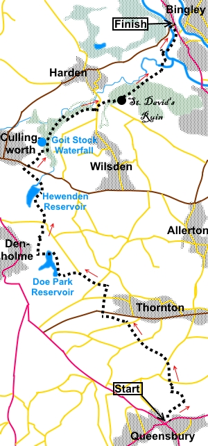 Introduction: This walk from
Queensbury to Bingley is packed with interesting features. It is also a
linear walk, best suited to and well served by public transport. It will be
of particular interest to railway buffs, as it follows some of the Great
Northern Railway Trail. It crosses two spectacular viaducts and there are
various information boards along the way. It also passes two pretty
reservoirs and an attractive stream with a wonderful waterfall.
Introduction: This walk from
Queensbury to Bingley is packed with interesting features. It is also a
linear walk, best suited to and well served by public transport. It will be
of particular interest to railway buffs, as it follows some of the Great
Northern Railway Trail. It crosses two spectacular viaducts and there are
various information boards along the way. It also passes two pretty
reservoirs and an attractive stream with a wonderful waterfall.
%20View%20to%20Rombalds%20Moor.jpg)
%20Entrance%20to%20Queensbury%20Tunnel.jpg)
%20St%20James%20Church%20Thornton.jpg)
%20View%20NE%20from%20Thornton%20Viaduct.jpg)
%20View%20SW%20from%20Thornton%20Viaduct.jpg)
%20Thornton%20Viaduct.jpg)
%20Doe%20Park%20Reservoir.jpg)
%20Hewenden%20Viaduct.jpg)
%20Bench%20at%20Hewenden%20reservoir.jpg)
%20Harden%20Beck%20at%20Hallas%20Bridge.jpg)
%20Goit%20Stock%20waterfall.jpg)
%20St%20David's%20Ruin.jpg)