|
Bingley
To Cullingworth
Starting point and OS Grid reference:

Bingley
– On street parking at Fairfax Road. (SE 107402)
|
Ordnance Survey Map
OL21 South Pennines – Burnley, Hebden Bridge, Keighley and Todmorden
OS Explorer Map 288 - Bradford
& Huddersfield.
Buy these maps from
List
of OS Maps
Note: If you use OS Maps on-line, you can download this route via this
link.
| |
Distance:
12.6
miles
|
Date of Walk:
11 January 2013
| |
Ascent:
Descent:
See Walking Time Calculator
|
1772ft (540m)
1776ft (541m)
| |
Traffic
light rating: 
(For explanation see My
Walks page)
| |


For advice on .gpx files see
My Walks page
|

Click
the PDF logo above to give a printable version of this walk without the
photos.
|
To
view route as a dynamic Ordnance Survey map click here.
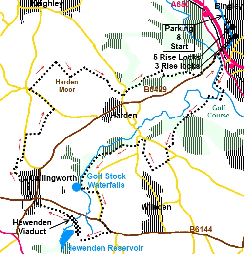
Introduction:
This walk from Bingley to
Cullingworth is something of a wandering ramble. It shows that it is
possible to have a decent walk without trekking off into the wilds. There
are a lot of interesting features on this walk including the famous Bingley
Five Rise Locks on the Leeds/Liverpool Canal, River Aire, Goit Stock
Waterfalls and the Hewenden Viaduct which you cross.
For me one of the most interesting features
was the George Hotel in Cullingworth for lunch! A wide range of Old Spot
beers are brewed “up t’road” by the owner of the pub and the quality
of the OSB I had and the food were exemplary.
Attractive black faced stone cottages abound
and the terrain varies from tarmac to field footpaths and moorland. The
walking itself is quite easy but the route is quite complicated to describe
in places and the directions are therefore quite lengthy. In part, the walk
follows the Millennium Way.
Unfortunately, although there are many good
views, on the day I did the walk, it was rather murky so I did not take view
photos.
The walk starts near the Bingley Five Rise
Locks and the best place to park is in the residential street Fairfax Road.
To get there from the centre of Bingley, turn north at the main traffic
lights up Park Road. Look out for Beck Lane on the left and follow it to a
small roundabout. Beyond is Fairfax Road. There is also parking on Beck Lane
but it is narrow.
Start:
Walk back along Fairfax Road (SE 107402)
and at the little roundabout, turn right down Beck Lane, to Bingley
Five Rise Locks. These were opened in 1774 and lift the canal some 60 feet.
%20Bingley%20Five%20Rise%20Locks.jpg)
Cross the canal via the bridge and turn left
to walk along the canal towpath to Three Rise Locks also built in 1774, this
time lifting the canal by 30 feet. Turn right here and take the footbridge
over the busy A650.
At Bingley’s main street, cross over, turn
left then right at the traffic lights down Millgate. Only 20 or 30 yards
from the junction, at the end of the first group of buildings on the left,
turn left along a narrow walled footpath indicated by a small green
fingerpost (SE 106394).
The footpath follows the course of the river
Aire for a short distance, then opens out into Myrtle Park. Turn left here
to walk along the edge of the park at the lower level (do not go up the
steps). At a split in the path, take the right hand fork and head towards
the footbridge over the river. Over this, follow the path alongside the
allotments.
At the end of the allotments, turn right
along the broad track which is part of the Millennium Way. Cross the
packhorse bridge at Beck Foot and turn left through the trees (SE 105384).
After about 300 yards, descend some stone steps on the left by a group of
buildings.
%20Packhorse%20Bridge%20and%20Ford%20at%20Beck%20Foot.jpg)
Cross another small packhorse bridge which
leads to the golf course. The way across the course is marked by white
painted boulders. Obviously, look out for flying golfballs and co-operate
with golfers as to who waits for whom!
As you exit the golf course, stay on the
Millennium Way which bears left towards the trees. In the trees, when the
path forks, keep left continuing to climb. You arrive at an area enclosed by
a wire fence. Go right and follow its perimeter. When it ends, go over a
stone stile and follow the obvious track across the fields.
At a metalled track (SE 096375), turn left
and almost immediately right indicated by a yellow arrow and a green
fingerpost.
The footpath exits into Coplowe Lane. Turn
right then as the road bends left, turn right along Cross Lane (SE 095371).
There is a public bridleway sign for the “Calder Aire Link” and
“Cullingworth 2½ miles”. This is a broad track to start with but then
narrows and descends towards Wilsden. As it starts to level out, look out
for the footpath on the right hand side indicated by a yellow arrow and turn
off here (SE 092369).
Follow this path alongside the wall, ignoring
a turn to the right close to a large rock across the path.
When the path forks, go left descending gently through the trees.
At the next fork, just before passing between
two large rocks, take the left fork. At a broad track (SE 090376), turn left
then immediately left again, following the yellow arrow. As the path opens
into another broad track, turn left again following the yellow arrow. You
should be passing some stone cottages below you on the right.
At the road, opposite the garden centre, turn
left and walk along the road for no more than 100 yards. Turn right at a row
of stone cottages Cheery Tree Row (SE 089375) following the Millennium Way.
The path follows a stone wall for a while and
then forks. The millennium Way marked with a yellow arrow goes left but you
go right, descending through the trees. Look out for a bungalow on the right
with a large wooden fence and turn right here and drop down to Harden Beck
(SE 081373). Turn left through Goit Stock Woods.
You arrive at Goit Stock Falls (SE 078367)
which are quite impressive after rain. The path climbs rather precariously
here. There is a handrail and you need to ascend to its right initially then
pass under it half way up. Continue to follow the beck until you get to a
footbridge. Do not cross it but turn sharp left here. An old mill is ahead
of you, which has been converted to residential use. You pass a double
fingerpost indicating a bridleway in your direction and a footpath to
Hewenden in the other.
%20Goit%20Stock%20waterfall.jpg)
Now leaving the Millennium Way, you arrive at
the hamlet of Hallas Bridge. Just past some garages, turn right passing Moss
Cottage.
%20Mill%20building%20at%20Hallas%20Bridge.jpg)
Follow the road as it bends left and follow
the Calder Aire Link.
We now have some road walking to do the
purpose being to give the opportunity to cross the Hewenden Viaduct and as
the road climbs, it is visible to the right in the distance. At the ‘T’
junction, turn right continuing to follow the Calder Aire Link.
%20Distant%20view%20of%20Hewenden%20Viaduct.jpg)
At the road junction (SE 081359), turn left
into the hamlet of Harecroft. As you get to the Station Hotel, turn right
down Station Road.
You get to the old station buildings, now
converted and extended cottages and then cross the former railway bridge.
Turn right through a metal gate joining the Great Northern Trail and
crossing Hewenden Viaduct. The path is now metalled and passes Hewenden
Reservoir where there is a handy bench for lunch. The Great Northern Trail
was formerly part of the Great Northern Railways linking Halifax, Bradford,
Queensbury and Keighley. The viaduct has 17 arches.
%20Hewenden%20Viaduct.jpg)
%20Hewenden%20Reservoir.jpg)
Stay on this path crossing the viaduct and
over a tarmac track and when the path forks, go right under the bridge. This
leads into Cullingworth, following the signs for Cullingworth Bowling Club.
The path goes round the bowling club and between the houses coming out in
Station Road. If you are frequenting the George or want to look at
the attractive church, turn right. Otherwise turn left.
%20St%20John's%20Church%20Cullingworth.jpg)
Cross the old railway bridge (SE 064367) and
turn immediately right along a broad track, passing the entrance to Lakeside
Farm. Take a path on the right hand side passing between two stone
gateposts. It descends gently and goes under a railway bridge and at a mill
dam, turn left. At a broad track, turn right.
As that track starts to bend right, go
through a metal walkers’ gate on the left indicated by a yellow arrow (SE
064371).
At the road turn left. You could now simply
continue along the road to The Guide pub or, to reduce the amount of road
waking and get better views, just after the national speed limit sign, turn
right on to a public bridleway signposted as the “Senior Way” (SE
065377).
Take a left fork, just after passing a gap
next to a gate, and head through a kissing gate up the moors. There are good
views here to the right to Cullingworth and Wilsden.
At the next road turn left (SE 071382). This
road can be quite busy. Walk along it to The Guide pub (SE 066387) and turn
right here signposted as a public bridleway and “To Calder Aire Link”.
At a ‘T’ junction of tracks (SE 071392),
turn right following the fingerpost for “Permissive Bridleway”.
As the track swings left to a farmhouse, take the right fork
indicated by the Calder Aire Link sign.
Follow the main bridleway route ignoring
minor turns off and at a fork turn right through a metal walkers’ gate. It
is difficult here to give accurate directions as there are so many tracks
amongst the trees but the route you want approaches a wall on the left.
Follow this along and at the corner, turn left (SE 074389). The route swings
round to the left and goes through a stile and across a short grassy section
before going down some stone steps to a broad track (SE 083387). Turn left.
The village below to the right is Harden.
The track becomes a proper road passing rows
of cottages and at the road junction, turn left.
After about 200 yards, turn right into the
St. Ives Estate (SE 087387). Stay on the tarmac drive through the estate
turning right at the Sports Turf Research institute. Go left at the Disabled
Care Centre drive.
Follow the drive to the road then turn left
to Bingley traffic lights and retrace your steps to the car.
If you need to buy any
hiking equipment/clothing before your trip see the Hiking
Store
All information on this
site is given in good faith and no liability is accepted in respect of any
damage, loss or injury which might result from acting on it.
|


.jpg)
.jpg)
.jpg)