
|
|
|
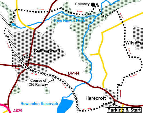
To view route as a dynamic Ordnance Survey map click here. Introduction: This is an easy 5.3 mile circuit of Cullingworth. The only difficulty was mud, not surprising as the walk followed a prolonged period of rain. I was glad of my gaiters! Harecroft’s claim to fame is that is once accommodated the railway station for Wilsden, built in 1886. It closed in 1955 and the line was removed. You can still pick out the old stationmaster’s house. Fortunately in 2005, the route was made available to walkers, cyclists and horse riders as the Great Northern Railway Trail, which, towards the end of this walk, gives you the chance to walk across the famous Hewenden Viaduct. There is good views form here, as long as you can see over the wall! Two of my other walks also incorporate this viaduct namely Bingley to Cullingworth and Queensbury to Bingley. The route incorporates some pleasant views, notably to Rombald’s Moor and over the valley where Cow House Beck flows. You also pass the somewhat rickety looking chimney for the former Goit Stock cotton spinning mill. This closed in the mid 1800s. The underground flue which led up from the mill is exposed in places and clearly visible. The chimney was put high up to avoid pollution in the narrow valley. The mill site is now a park homes site. The walk starts on Station Road at Harecroft, where there is ample parking. To get there, follow the B6144 east from Cullingworth or west from Wilsden. Station Road is in the centre of Harecroft, opposite the Station pub. Start: From the car, walk back up Station Road to the hamlet and at the main road, turn right. After only a few yards, turn left to follow a public footpath fingerpost for “Brown Lee Lane”.
When the track forks (SE 080364), the right hand arm being marked “Private”, go left, passing under some power lines. Reach a metal gate into a field and fork right.
Continue past the farm, following the wall on the right hand side. The path is in a “ditch” here. I did the walk after very heavy rain so walked along the left hand top of the “ditch”. When the path opens into a field, follow the left hand boundary to a stile. Cross a second stile and follow the broad track down to the road (Dye House Lane). Turn left along it (SE 088364).
After almost three hundred yards (or about one hundred and fifty yards after the last house), turn right over a stile (SE 086365) and follow the right hand boundary of the next two fields. At a house, go through the stile down to the lane. Cross straight over, following a public footpath fingerpost. Follow the path down the field, bearing slightly right, cross another stile and follow the right hand boundary of the field beyond and ignoring a stile on the right. Head to the farm at the bottom of the field and go through a kissing gate to its left. Over the lane, go through a second kissing gate and follow the right hand field boundary. At the bottom of the field, go through a walkers’ gate into the woods (SE 083373) and follow the path to the left. Cross a single stone slab bridge and work your way under the electricity pylon. When the path forks, keep left following the boundary wall of the wood. Go through a stile, then a gate, and follow the right hand boundary of the field. About half way along it, go through a gate to re-enter the woods. Follow the downhill path, ignoring one off to the right after fifty yards or so. You arrive at a high fence by the park homes. Turn right at the end of it and almost immediately left to cross a footbridge. When you arrive at the tarmac drive in the site, turn left for only a few yards before turning right to follow a fingerpost for “Senior Way”, alongside a high hedge. Look out for a path on the left, turning back the way you have come but climbing slightly and turn left along it (SE 080374), passing an old chimney. Its underground flue is visible and you cross over it, following the path along the contour of the field.
Go through a stile and turn right, to follow a wall on the right. You get to a point where another wall is joined which stands a little proud of the first wall, forming a corner. Turn right over the stile here, following the left hand boundary. Look out for a stile on the left (SE SE075372) – this was blocked by wire mesh fencing and has been reported to Bradford MDC). Cross this stile and turn right. If the stile has not been unblocked, you can carry on to the end of the fencing and pass through a dilapidated wall instead. There was a large flat rock along here which made for a pleasant sandwich stop with a nice view.
Continue to follow the path along the top of the valley until you climb a stone step stile to the road. Cross the road, slightly left and then along Hunters Green, following a public footpath fingerpost. Follow the road through the group of houses and when you get to the hammerhead turning area. More or less straight ahead of you, follow the green track. In the field, keep straight ahead, crossing a dilapidated wall heading initially for the roof you can see ahead of you. As you get closer to the farmhouse, go through a gate in the right hand wall go through it and turn left to the road. Cross the road bearing slightly left and cross a stile to follow a public footpath fingerpost then shortly left through a walkers’ gate (SE 065373). Arrive at a broad track, next to the old mill dam. Turn right. When the track splits, take the left fork and pass under the railway bridge.
At a tarmac lane, turn left. Continue over a cross roads of tracks and continue to the road where you turn left. At the mini-roundabout, you need to turn left to do a brief anti-clockwise loop to the access to the old railway line. Turn left again along New School Lane.
At the end of New School Lane is the unmistakable entry to the Great Northern Railway Trail. Follow the course of the old railway crossing the famous Hewenden Viaduct. On reaching the road just after it, turn left to return to Harecroft. If you need to buy any hiking equipment/clothing before your trip see the Hiking Store All information on this site is given in good faith and no liability is accepted in respect of any damage, loss or injury which might result from acting on it.
| | |||||||||||||||||

.jpg)
.jpg)
.jpg)
%20Hewenden%20Viaduct.jpg)
%20View%20over%20Bingley%20to%20Rombalds%20Moor.jpg)
%20View%20over%20Harden%20to%20Baildon%20Moor.jpg)
%20Chimney%20which%20once%20powered%20Goit%20Stock%20Mill.jpg)
%20View%20to%20Cow%20House%20Beck.jpg)
%20Catstones%20End.jpg)
%20Old%20mill%20dam%20at%20Cullingworth.jpg)
%20Track%20passing%20under%20railway%20line.jpg)
%20Joining%20the%20old%20railway%20route%20to%20Hewenden%20Viaduct.jpg)