
|
|
|
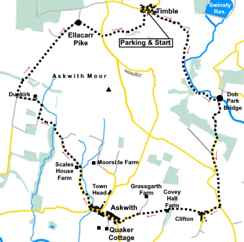
To view route as a dynamic Ordnance Survey map click here. Introduction: This walk must represent one of the best routes for its length in the Lower Wharfedale area. I have walked some sections before, notably on my Washburn Valley and Timble and Burley in Wharfedale to Ben Rhydding walks but this circuit demonstrates the beauty of the area to a much greater extent. It is varied, crossing pleasant farmland, open moorland, woodland and a riverside walk. There are fabulous views over Wharfedale, to the north into the Nidderdale Area of Outstanding Natural Beauty and over the tranquil Washburn Valley, which seems untouched by time, not least because there is no road running through it. The route starts in the picturesque hamlet of Timble, a conservation area. An interesting historical fact is that in the 17th century, witches were tried, following accusations by a local poet but they were acquitted (twice!) at York. The hamlet has a number of listed buildings, not least the upmarket Timble Inn (Grade II). The walk passes Dob Park pack-horse bridge. This too is Grade II listed and possibly originates from the 17th Century. It has a narrow cobbled path across its top and an unusually large arch for this type of bridge, no doubt as protection in times of flood. Askwith too has a number of listed buildings, not least the attractive Manor House, dating from 1681. It is also home to the Askwith Arms with the opportunity for refreshment about half way round, with a great view down the valley from the patio area. Check the opening hours. The steepest part of the walk is from Dob Park Bridge but on the plus side, this is on a tarmac lane. The remainder of the route is straightforward. Timble lies off the road from Otley to Blubberhouses. From Otley, cross the river bridge and just keep going, up the hill, for just over five and a half miles then turn right into the hamlet (signposted). From the A59 at Blubberhouses, turn south at Blubberhouses church, signposted for Otley. The turn for Timble is on the left, after one and a half miles. Start: Facing the Timble Inn (SE 180530), walk down its left hand side and at the lane, turn left.
As you leave the hamlet, the lane becomes a stony track. Go through two gates and when the track splits, go right. At the next corner, turn right through a gate. Bear left, heading for the diagonally opposite corner, where you turn left to a gate. Go through this and turn right along a walled lane (SE 189524) (High Lane Track, part of the Six Dales Trail). When the lane ends at a field, follow the right hand boundary for about a hundred yards. Before the field starts its more steep descent, turn right through a gateway. Head downhill to join the riverside path then turn right to follow the River Washburn. Follow the riverside path until you reach Dob Park packhorse bridge (SE 196508).
At the bridge, turn right and follow the lane for a mile. It is quite steep for much of its length!
Just over a hundred yards before meeting the main road, look out for a threeway fingerpost on the left. Follow the “Public Footpath” fingerpost, crossing the stone stile. A useful aiming point at this stage is the radio mast ahead. On the horizon to the left is Almscliffe Crag. At the far side of the field, cross a stile and follow the fenced path. In the fields beyond, keep to the left boundary. In the last field, which is obvious as you cannot continue ahead, cross a stile in the bottom right hand corner, on to the road. Turn left along the road. It is quite busy but there are adequate verges and the distance is only about a hundred yards. Turn right at the junction, following the road sign for “Clifton”. Follow the road, just until it bends left into the village proper. On the corner, turn right following the public footpath fingerpost and a sign indicating “Top Row”. There follows a quite difficult to spot dog leg. Follow the path until the way is barred by the gate to a property. A few feet before the gate, turn left alongside some stone built garages, then right across a gravel yard. You then turn right along a narrow walled path indicated by a white arrow. Go through a metal gate into a field marked with a “Welcome Way” arrow. From here the way is well marked with these arrows. Cross the field until you meet a broad gravel track by a cattle grid. Cross the track and keep straight ahead, keeping the field boundary on your left. Cross a stile at the end of the field and keep straight ahead following the “Welcome Way” sign. Cross a stream via a bridge and turn right. At the farm (Covey Hall Farm) (SE 184483) turn right following the obvious track. Enter a field and bear left to a stile marked with yellow arrows. Cross and in the next field, continue in the same line, to the diagonally opposite corner. Cross a footbridge then follow the left hand boundary. The footpath curves left in front of a bungalow, to join Hallam Lane (SE 178482). Turn left and follow this to the outskirts of Askwith. Turn right at the junction. Walk through the village, passing the Manor House and The Askwith Arms. As the road bends left, turn right (Hall Lane) (SE 167484). This looks like the private entrance to a drive, with a (usually open) gate.
After about half mile, the tarmac gives way to a stony track. Continue to follow this to a sharp right hand bend. Turn off left at the bend over a stone step stile (SE 160500). A yellow arrow for the Welcome Way marks the route. Turn right, keeping to the left of a short section of wall. At the end of a small wood on the right, turn left to the corner of a fence, where another yellow arrow directs you. Follow the edge of the trees on the left until you reach a stile on the left into the trees. Cross Hundwith Beck and follow the obvious path through the trees, as it bears right.
Emerge from the trees over a step stile. There are good views to the left over Wharfedale and Ilkley to Rombalds Moor. Head toward the right of the clump of trees you can see directly ahead of you. As you crest the high point of the field, you will see a stile and post with a yellow marker. Cross the stile and turn right on a wide drive (SE 155505), crossing a cattle grid and later passing a small lake.
Just as you reach the house, Dunkirk, just before the cattle grid, turn left through a gateway marked with a yellow footpath arrow and follow the fence on the left (SE 155508). At the end of the field, reach a gate but do not go through it. Instead, turn right, following the line of the wall on the left. After going through a gate, you cross a very narrow bridge over a stream.
Continue to follow the wall until, in a corner, you reach a stone step stile. Cross it and bear right to the corner of the trees. Follow the obvious footpath as it gently climbs NE across the moor to Ellarcarr Pike (SE 160523). As you reach the Pike, you will see the white golf balls of RAF Menwith hill in the distance.
Go through the unusually styled metal gate and turn right following the broad track.
Continue down this track for just under half a mile until you reach a cattle grid (SE 164527). Go through the gate alongside it and cross the ladder stile immediately on the right. Head across the field to the next ladder stile, which you can see and once over this, head for the diagonally opposite corner of the field.
Cross another stile and continue in the same direction to the opposite corner. Go through the gateway and keep straight ahead, keeping to the right of some large rocks, to a ladder stile, which you cross to the road. Straight over the road and you cross another ladder stile. Keep to the left hand boundary of the tree planted area and the next field. At the end of that field, turn left through the gate and now follow the wall on the right. Arrive at two gates and go through the one on the left. Follow the obvious path straight ahead. Through the next gate, keep just to the right of the barn ahead. Follow the line of the field boundary on the left and in the next field until, in the left hand corner of this second field, is a stile, not really visible until you reach it. Cross and keep straight ahead in the direction of the yellow footpath arrow. Follow the fence on the right. The path descends down some rough steps to the little valley on the right. Cross the footbridge (SE 179526) and keep to the left hand side of the field beyond. The hamlet of Timble is ahead. Follow the path through a brief ‘holly tunnel’ and straight ahead into Timble. Keep straight ahead, then turn right to return to the village centre. If you need to buy any hiking equipment/clothing before your trip see the Hiking Store All information on this site is given in good faith and no liability is accepted in respect of any damage, loss or injury which might result from acting on it.
| | |||||||||||||||||

.jpg)
.jpg)
.jpg)
%20Timble.jpg)
%20%20View%20down%20the%20Washburn%20Valley.jpg)
%20Dob%20Park%20Bridge.jpg)
%20Looking%20down%20the%20Washburn%20valley.jpg)
%20Manor%20House%20Askwith.jpg)
%20View%20from%20Askwith%20Arms.jpg)
%20Hundwith%20Beck.jpg)
%20Lake%20at%20Dunkirk.jpg)
%20View%20over%20Wharfedale.jpg)
%20View%20at%20Ellacarr%20Pike.jpg)
%20Telephoto%20shot%20of%20Menwith%20Hill.jpg)
%20View%20over%20The%20Washburn%20Valley%20to%20the%20Norwood%20Transmitter.jpg)
%20Boundry%20stone%20on%20the%20descent%20from%20Ellacarr%20Pike.jpg)
%20View%20over%20the%20Washburn%20Valley%20%20to%20Norwood%20Transmitter.jpg)