|
Burley-in-Wharfedale
to Ben Rhydding Via Askwith and Denton
Before
attempting this walk, please see Stepping
Stones information
|
Starting
point and OS Grid reference:

Burley-in-Wharfedale
train station (SE 164458) – Car park but limited space – see text.
|
Ordnance
Survey Map
OS
Explorer 297 – Lower Wharfedale & Washburn Valley.
Buy this map from
List
of OS Maps
Note: If you use OS Maps on-line, you can download this route via this
link.
| |
Distance: 10.3
miles
| |
Traffic light rating:

(For explanation see My
Walks page)
| |


For advice on .gpx files see
My
Walks page
|

Click
the PDF logo above to give a printable version of this walk without the
photos.
|
To
view route as a dynamic Ordnance Survey map click here.
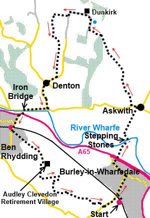
Introduction:
This walk from Burley-in-Wharfedale
exploits the recently (summer 2013) restored Burley stepping stones across
the river Wharfe. It must be emphasised that these stones are only exposed
when the river is low. The Wharfe rises (and falls) very quickly, so after
any kind of wet spell, they are likely to be under water. In these
circumstances, do not attempt a crossing. At best the stones will be
slippery and you will probably get wet. Worst case, you could be swept away.
It pays to have a reserve walk in mind, just in case.
At the bottom of the page is a real time
gauge indicator of the river level at Ilkley, some 4 miles upstream. This
will give some indication of the likelihood of the stepping stones being
available.
Repair of the stepping stones adds welcome
new possibilities to walks from this village.
A look at the OS map will show all round this
route there are many footpath options. The directions are therefore
necessarily wordy to keep you on the right track.
The route passes very briefly through
Askwith, then through the Denton Estate to the small village of Denton,
before progressing to Ben Rhydding where there is the possibility of
refreshment at the Wheatley Arms. It also passes Ben Rhydding train station,
where the walk can be cut short by returning by train to Burley, if
exhaustion or excess “refreshment” has set in!
From various vantage points, there are good
views of lower Wharfedale.
Some road walking is involved but this is
mostly on quiet roads.
The walk starts from Burley-in-Wharfedale
train station. There is a car park but weekdays it is filled by Leeds
commuters. There is parking behind the Queens Hall on Main Street and
another close to where the route turns off Main Street.
Additionally, there is what is in effect a
large lay-by on the north side of the A65 just after the roundabout at the
western (Ilkley) end of the Burley-in-Wharfedale dual carriageway by-pass.
If you park here, walk back to the roundabout and take the first exit,
following the road as it bends right. This is Leatherbank and you pick up
the walk at # below.
Start:
Exit Burley station and turn right downhill along Station Road. At the
bottom (mini roundabout) turn left and walk along Main Street. Turn right
just before the stone village name sign and electricity substation, to walk
along the signposted bridleway, which is a tarmac path at this point (SE
162468).
The path goes through a tunnel under the A65
Burley bypass and meets a lane. This is Leatherbank although there is no
sign #. Follow this lane to the right. It eventually becomes a stony track and
about 100 yards from the end of the tarmac, turn left to the river Wharfe
and cross the river via the stepping stones (SE 166474). Note the old mill
leat which now supplies a hydroelectricity plant and the weir.
%20Reflections%20on%20the%20leat.jpg)
%20Weir%20at%20Burley.jpg)
%20Stepping%20stones%20at%20Burley.jpg)
%20heron%20seen%20at%20Burley.jpg)
On the north bank, bear left about 45° to a
walkers’ gate in the corner of the field. Follow the next field along its
left hand boundary and through another walkers’ gate. Views of Wharfedale
and the Cow and Calf rocks start to open up. Continue your line of travel in
a straight line, arriving at the road in Askwith via a narrow walled
footpath. Turn left along the road.
%20Cow%20&%20Calf%20rocks.jpg)
Stay on the road for about 300 yards and when
it bends sharply left, take the tarmac lane off the bend on the right (SE
167484). Continue along the lane past Scales House Farm where the tarmac
turns to a stony track. Stay on it, passing a small lake. When the track
bends right at 90° to go to Whin Hill Farm, go left here, through a farm
gate (SE 160500). There is a yellow footpath arrow on the gatepost.
Go over a ladder stile bear left towards the
trees and turn right to follow an obvious broad track, to a gate with a
yellow arrow. Once through the gate, just ahead of you on the left is a
stile to a path through the trees, crossing a small stone bridge.
The path through the trees is fairly clear
but is marked here and there with yellow tape on tree trunks and posts.
Exit the trees over a stile (SE 158503) and
at this point is a great view over Wharfedale towards Ilkley and Ilkley
Moor. The route from the stile across the field may not be all that clear if
it has not been walked recently. Bear slightly right (305° magnetic)
towards the copse of trees. As you get closer to the trees, you will see a
ladder stile. Go over this and turn right on a broad track (SE 155505). Pass
a small lake.
%20Lake%20near%20Dunkirk.jpg)
As the track swings right over a cattle grid,
to the farm (Dunkirk) go left through the gate ahead marked with a yellow
footpath arrow and follow the obvious track along the left hand side of the
field to its corner where there are two gates. Go through the one straight
ahead and turn left to follow the wall.
At the bottom of the field turn right, again
following the wall. At the far side of the field, go through the wide gap
between the trees and a five bar gate.
Keep to the left of the next field to a gate
and turn left on the broad track (SE
146508). As the track starts to swing to the right, head left and cross the
ladder stile at the corner by the trees.
From this stile, cross the field bearing
right aiming to meet the opposite wall about half way along (175° magnetic
from the ladder stile). You are looking for a stone step stile over the far
wall. If unsure, you could turn right and follow the wall round until you
meet it. Cross this stile and head downhill for the left corner of the field
and cross the fence (the “stile” here is a series of wooden bars). Go
straight ahead until you meet the wall before the farm (Yarnet House farm)
and turn right (SE 147501).
%20View%20over%20Denton%20to%20Ilkley.jpg)
At the bottom of the field, go through the
five bar gate by the power pole and keep straight ahead. Aim for the left
hand end of the bank of trees ahead. Your route is now in more or less a
straight line until you meet the road at Denton (Smithy Lane).Yellow
footpath arrows guide you. Turn right at the road.
As you approach the hamlet of Denton, note
the little St. Helens Church with its unusual round tower. If you want a
closer look, turn left at the post box and telephone box. The presence of a
church here dates back to the 14th century but the current
building opened in 1776.
%20St%20Helens%20Church%20Denton.jpg)
Return to the centre of the hamlet and turn
left at the pretty village green. The strange stone object on the green is a
late 18th century former well head and fountain (according to
English Heritage). There is a bench here where you can sit for sandwiches.
%20Denton%20Village%20Green.jpg)
Follow the road to the ‘T’ junction, turn
right for just under half a mile then go left over the Iron Bridge (road
sign for Ilkley). Be careful here as the bridge is single track and quite
busy. At the main A65, turn right for a mere 100 yards (pavement) then go
left up Wheatley Lane.
%20Iron%20Bridge%20Ilkely.jpg)
Walk under the railway bridge and as it bends
right, fork left. To visit the Wheatley Arms, continue up Wheatley Lane
2/300 yards. Otherwise, turn immediately left to walk up Ben Rhydding Drive,
between the stone gateposts. You follow Ben Rhydding Drive for three
quarters of a mile to the entrance to Audley Clevedon Retirement Village
then turn right (SE 143468). There are good views over Denton Moor.
%20View%20to%20Denton%20Moor.jpg)
Pass Wharfedale Grange Farm and as the track
forks, go left. As the track swings to the right, take the footpath on the
left through a kissing gate. The path descends to another kissing gate and
you cross a stream via two large stone slabs.
When the path splits, fork right. Go over
another stream and through a kissing gate, turn right and walk up the track
towards the moors. Pass Mount Stead and as the track bends, look out for a
gate on the left marked with a blue bridleway arrow.
%20View%20to%20Otley%20Chevin.jpg)
Through this gate bear left descending gently
at about 45° to the opposite corner. Go through another gate and follow the
walled track to join a broad track where you turn right. When the track
splits, keep right. Do not go straight ahead to the barns. The route
follows the broad track around the area of the barns and through the
farmyard.
Stay on the track ignoring any turns off
until you reach a sharp right hand bend (SE
147460). Go left here indicated by a footpath marker on the fence. At the
wall corner, the track swings left. Follow this obvious path through one or
two kissing gates and when it emerges on to a broad drive via a metal gate,
turn right.
Walk along the drive for 250 yards or so and
turn off left on to a footpath indicated by a yellow arrow. This takes you
to another broad drive, turn right. At the road, turn left to return to
Burley station.
If you need to buy any
hiking equipment/clothing before your trip see the Hiking
Store
All information on this
site is given in good faith and no liability is accepted in respect of any
damage, loss or injury which might result from acting on it.
|


.jpg)
.jpg)
.jpg)