|
Lanzarote
Walk - Atalaya de Femes
|
Starting
point:
Car
parking in the centre of Femes
|
Map
I
have found this to be the best map for both walking routes and driving, from
Discovery Walking Guides Ltd
Lanzarote
Tour and Trail Map 1:40,000 scale

| |
Distance:
5.3
miles
| |
Traffic light rating:


(For explanation see My
Walks page)
More great Lanzarote
Walks
|

Click
the PDF logo above to give a printable version of this walk without the
photos.
|
Introduction: Atalaya de Femes is the second highest mountain on
Lanzarote at 611 metres (2004 ft). It is only surpassed by Peñas
del Chache (615 metres), above the cliffs of Famara. However, Peñas del
Chache is topped by a military installation and is off limits.
From
Atalaya de Femes summit are good views of the Montañas
del Fuego, the east and west coasts of the island and to the south,
Playa Blanca and Fuerteventura.
Unfortunately,
its summit is marred by a veritable forest of every sort of antenna you can
think of but one cannot question the practicality of the location. There is
also the Spanish equivalent of a trig.point.
However,
do not let this put you off. This is a splendid ridge walk.
The
walk starts from the lovely hill-top village of Femes which has a balcony
from where there is a stunning view down to Playa Blanca and across the sea
to the island of Fuerteventura. It is worth having a wander round before or
after the walk. There are a few bars and a nice plaza and church. There
is limited parking at the centre of Femes.
The
route unfortunately starts with a walk along the LZ-702 but there is
pavement initially and then a wide, if rough, verge when the pavement ends,
on the opposite side of the road. The walk ends with a somewhat slithery
walk down the access track from the masts.
To
get to Femes, either take the Calle Del Rubicon out of Playa Blanca (steep
road with hair-pin bends) or go via the LZ-702 from the roundabout on the
LZ-2 at Uga.
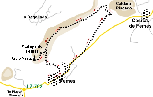
Start: From the village
centre, go left to walk down the
main road, the LZ-702. There is pavement to start with and when it runs out,
cross the pedestrian crossing to walk down the left hand side of the road on
the rough verge.
%20View%20to%20Casitas%20de%20Femes.jpg)
At
the edge of the village, pass a bus shelter then a roughly circular area at
a road junction planted with palm trees. Ignore the dirt track which goes
off to the left immediately after this road junction and continue until you
reach the road sign indicating you are leaving Femes (“Femes” crossed
through with a red line).
Around
100 yards after this sign, at the end of the field on the left, turn left on
to a broad dirt track. There is a white painted small post at either side of
the track.
%20View%20back%20to%20femes.jpg)
Follow
this track along the top edge of the fields for some distance. Eventually,
it narrows to a mere footpath and starts to climb gently. It is marked by a
few stone cairns. After passing to the rear of a rough farm building/hut, it
crosses a small gully and rises to meet a broader track on the small ridge.
Turn left, uphill.
You
begin to get sight of the east coast.
The
track climbs and just as it reaches a cultivated area (not easy to pick out
immediately), before the top of the ridge, fork right, crossing a small,
shallow, rough rainwater gully. There is a small cairn. This is the only
tricky bit of navigation on the walk.
Cross
two further rainwater gullies and after the second, the path swings left,
passing another cairn on the left.
On
reaching a banking, which seems a result of digging out a drainage ditch
next to it, turn left along the banking. The radio masts at the summit soon
come into view and the path broadens and becomes clearer. There are views of
Montana
Cuervo.
%20Montana%20Cuervo.jpg)
You
also see several other landmarks including Montana Guardilama and Montana
Tinasoria.
%20Montana%20Guardilaria%20and%20Montana%20Tinasoria.jpg)
%20View%20along%20summit%20ridge.jpg)
%20View%20to%20la%20Degollada.jpg)
Follow
the path to the summit. There is a “false” summit first which is the
steepest part of the walk. After this the path levels out and descends
gently to the access track to the summit. Turn right here.
%20View%20west.jpg)
%20Wild%20flowers%20in%20a%20caldera%20near%20the%20summit.jpg)
%20Atalaya%20de%20Femes%20summit.jpg)
%20Trig%20Point.jpg)
From
the summit, follow the broad track back downhill, passing the point where
you joined it.
%20View%20to%20Playa%20Blanca.jpg)
%20View%20to%20Puerto%20del%20Carmen.jpg)
The
track zig-zags down the hill eventually arriving at a couple of posts
normally with a chain across to prevent unauthorised vehicles. Just after
this, the track curves left to join another track. Turn right here.
%20Femes.jpg)
The
track descends into Femes. When it meets a tarmac road, turn left and at the
concrete road, keep straight ahead back to your starting point.
%20Church%20and%20plaza%20in%20Femes.jpg)
If you need to buy any
hiking equipment/clothing before your trip see the Hiking
Store
All information on this
site is given in good faith and no liability is accepted in respect of any
damage, loss or injury which might result from acting on it.
|


.jpg)
.jpg)
.jpg)