|
Lanzarote
Walk - Montana Cuervo
|
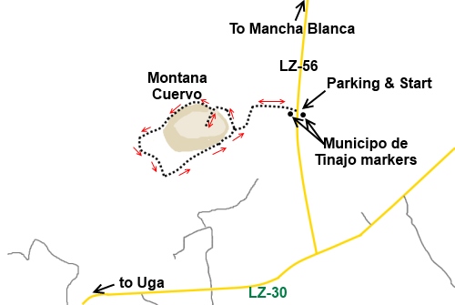
Starting
point:

Roadside
parking on the LZ56, just by the Municipo de Tinajo markers.
|
Map
I
have found this to be the best map for both walking routes and driving, from
Discovery Walking Guides Ltd
Lanzarote
Tour and Trail Map 1:40,000 scale

| |
Distance:
2.2
miles
|
Date
of Walk: 30 January 2015 (revisited)
| |
Traffic light rating:

(For explanation see My
Walks page)
More great Lanzarote
Walks
|

Click
the PDF logo above to give a printable version of this walk without the
photos.
|
%20Montana%20Cuervo.jpg)
Introduction/Start:
This an easy level walk around the volcanic cone Montana Cuervo which
should be within virtually anyone’s capabilities. It is worth doing even
though it is short because it reveals some of the amazing different rock
colours which volcanic activity causes. The entry into the crater itself is
straightforward and again the contrasts of colours in the rocks are amazing.
There are some tremendous views across the
lunar like landscape.
Montaña Cuervo was the first volcano created
during the 1730 to 1736 Tymanfaya eruption, which changed Lanzarote’s
landscape for ever.
I first visited this walk some years ago. The
route itself has not changed but there are now a number of information
boards as you circumnavigate the cone. Also, a purpose built car park has
been created a few hundred yards further north of the lay-by mentioned
below, which I do not recall from previously. A well manicured path runs
from this to the route round the cone.
One disadvantage of the large car park and
the easy nature of the walk is that coaches sometimes turn up. This can
increase your company on the walk so try and pick a “coachless” time!
%20View%20North%20East%20to%20Caldera%20Coldorada.jpg)
The walk starts from a lay-by at the west
side of the LZ-56 road which runs due north to Mancha Blanca from the LZ-30.
The lay-by is next to large marker signs on stone plinths at either side of
the road indicating the boundary of the Municipo de Tinajo, so is pretty
much unmissable.
The path from the lay-by is obvious. Just
follow it to the base of the cone and walk around it. It does not matter
which way round you go but do take the opportunity to go through the gap
into the crater itself.
%20Entrance%20to%20Montana%20Cuervo%20crater.jpg)
%20Crater%20floor.jpg)
%20Crater%20walls.jpg)
%20Looking%20back%20at%20the%20crater%20exit.jpg)
%20View%20across%20the%20lunar%20landscape.jpg)
If you need to buy any
hiking equipment/clothing before your trip see the Hiking
Store
All information on this
site is given in good faith and no liability is accepted in respect of any
damage, loss or injury which might result from acting on it.
|


.jpg)
.jpg)
.jpg)