|
Stainforth
to Giggleswick Scar and Feizor
Starting point and OS Grid reference:

Stainforth
– pay and display car park (SD 821673)
|
Ordnance Survey Map
OL41 – Forest of Bowland & Ribblesdale and OL2
Yorkshire Dales – Southern & Western Areas.
Buy
these maps from
List
of OS Maps
Note: If you use OS Maps on-line, you can download this route via this
link.
| |
Distance: 8.2 miles
|
Date of Walk: 4 December 2013
| |
Ascent:
Descent:
See Walking Time Calculator
|
1195ft (364m)
1193ft (363m)
| |
Traffic
light rating: 

(For explanation see My
Walks page)
| |


For advice on .gpx files see
My Walks page
|

Click
the PDF logo above to give a printable version of this walk without the
photos.
|
To
view route as a dynamic Ordnance Survey map click here.
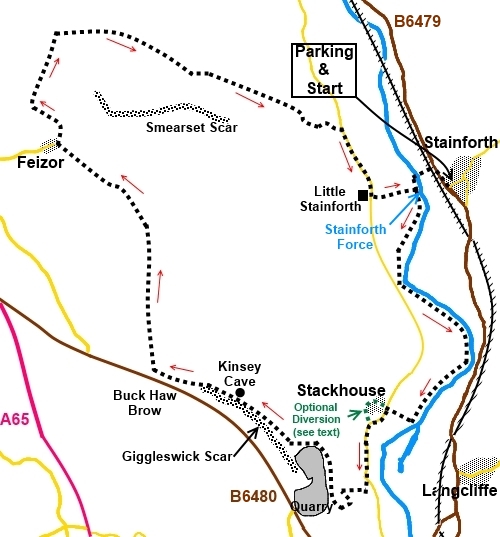
Introduction:
This walk from Stainforth initially
follows the River Ribble, passing Stainforth Force, a pleasant set of falls,
before climbing above Giggleswick Scar, eventually reaching Feizor. This is
dramatic limestone country with impressive rocky outcrops. There are a
number of caves along Giggleswick Scar beloved of potholers/archaeologists,
not least Kinsey Cave.
Kinsey Cave is a Scheduled Ancient Monument
and a number of archaeological remains have been excavated.
There are great views from various sections
of this walk, especially from above Giggleswick Scar, where sits
Schoolboys’ Tower. This huge cairn gets is name from a tradition where
graduating students from nearby Giggleswick School would each put a rock on
the cairn to celebrate the end of their time at school.
From Giggleswick scar, the route progresses
to the quaint hamlet of Feizor, where there is the popular Elaine’s Café!
The route out of Feizor is via a “pass” with magnificent limestone scars
alongside. At the head of the “pass” are a number of rocks which provide
a good picnic spot with fine views.
The walk starts from the pay and display car
park at Stainforth where there are public toilets. To get there, from the
centre of Settle (just off the A65), take the B6479 for just over 2 miles to
Stainforth. The car park is by the B6479, on the very edge of the village.
Start:
From the car park (SD 821673), return to the B6479 and turn right. Walk along it for
about 200 yards and take the next turn left (SD 819674), along a narrow road
marked “Unsuitable for Caravans”. Cross the railway bridge and keep
straight ahead, following the finger post you will come to for “Pennine
Bridleway and Little Stainforth.
Cross the packhorse bridge over the River
Ribble, then turn left through the gap stile following the fingerpost for
“Stackhouse 1¼ miles. Almost immediately, you arrive at Stainforth Force.
%20Stainforth%20Bridge.jpg)
%20Stainforth%20Force.jpg)
%20Stainforth%20Scar.jpg)
%20Looking%20North%20along%20Ribblesdale.jpg)
Keep to the footpath alongside the river for
about one and a half miles until you reach a metal footbridge. Do not cross
the bridge but turn right to follow the fingerpost for “Stackhouse” (SD
817655). At the road, turn left.
You now have the choice whether to just walk
along the road to the next section of the walk or whether to “have a
nosy” at Stackhouse itself. There is not much to see but there are some
lovely old buildings. If you do want a look, take the first right, in the
direction of the public bridleway sign for Stackhouse. Pass the gate to
Abbeylands, keeping straight ahead on the obvious broad track. Go through a
five bar gate then follow the stone wall effectively circling the hamlet
anti-clockwise – see the green dotted route on the sketch map. Continue,
until reaching a small walkers gate, to rejoin the road, where you turn
right (SD 814655).
Continue along the road for a quarter of a
mile and look out fore a slightly elevated house on the right called The
Ryddings. Its gateway is recessed. Go through the small walkers’ gate in
the left of the recess, then through a gated stile (SD 814650). Follow the
footpath across the field to the trees and go through another gated stile.
Turn right then, almost immediately, climb
the ladder to the left, to reach a broad track. Turn right on this track.
Stay on the track, passing through a metal gate, as it curves left then
right, climbing to the wall by the quarry. As you climb, there are excellent
views along Ribblesdale to Pen-y-ghent.
%20View%20North%20along%20Ribblesdale%20Pen-y-ghent%20under%20cloud.jpg)
The track becomes a narrower footpath as it
climbs to the top of the quarry. Follow the quarry perimeter.
As you round the top of the quarry, you will
catch sight of the massive round cairn Schoolboys’ Tower. There are other
cairns but there is no mistaking this one. Make your way to it, from where
there are great views.
%20Cairns%20above%20Giggleswick%20Scar.jpg)
With Schoolboys’ tower at your back and the
quarry to your right, walk straight ahead (approx. north) to meet a broad
grassy path which bears left to Giggleswick Scar. You should come to a
fingerpost indicating the footpath.
%20View%20along%20Giggleswich%20Scar.jpg)
%20View%20SE%20From%20Giggleswick%20Scar.jpg)
%20View%20towards%20Settle%20across%20golf%20course.jpg)
Along here, you pass Kinsey Cave (SD 804657).
%20Kinsey%20Cave.jpg)
Continue along the path and at a walkers'
gate, go through it and bear right. The route is obvious.
After going through a five bar gate, where
there is a small sheepfold alongside, the track splits. Keep left following
the wall.
At a junction of tracks with a three-way
fingerpost, follow the public bridleway for “Feizor ½ mile”.
%20Approaching%20Feizor.jpg)
At the outskirts of Feizor (SD 790676), meet
the road at a three-way fingerpost and turn right to follow the “Pennine
Bridleway” and “Little Stainforth” direction. Walk straight through
the hamlet on the road, ignoring a right turn footpath for Stainforth
(unless you want to shorten the walk) and passing the tearooms.
The road becomes a stony track, climbing
gently past some impressive limestone cliffs.
There are some good “picnic rocks” along here. Stay on the track
until you meet a collection of gates and a sheep pound (SD 790685). Turn
right here over a ladder stile for “Hargreaves Barn 1½ miles”.
%20Scar%20leaving%20Feizor.jpg)
%20View%20to%20Pen-y-ghent.jpg)
%20Telephoto%20shot%20of%20Pen-y-ghent.jpg)
When the path forks, take the left fork and
cross another ladder stile. The path passes along a shallow valley. The high
ground to the right is Smearsett Scar. There is a trig. point up there and I
have previously walked along this ridge, from which there are good views. On
this occasion however, I remained on the valley path. The route to
Hargreaves Barn is easy to follow with a series of ladder stiles. On
reaching a road turn right for Little Stainforth.
%20Path%20to%20Stainforth.jpg)
%20View%20NW%20with%20Ingleborough.jpg)
%20Almost%20back%20to%20Little%20Stainforth.jpg)
In Little Stainforth, there is a cross roads
with a thee-way fingerpost. Turn left for
“Stainforth ¾ mile”. After passing the camp ground, you will
arrive at the packhorse bridge crossed on the outward journey. Cross it and
retrace your steps to the car park.
If you need to buy any
hiking equipment/clothing before your trip see the Hiking
Store
All information on this
site is given in good faith and no liability is accepted in respect of any
damage, loss or injury which might result from acting on it.
|


.jpg)
.jpg)
.jpg)