|
Litton
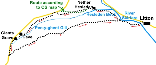
to Pen-y-Ghent Gill and Giants Grave
|
Starting
point and OS Grid reference:

Litton
village – roadside parking (SD 907741)
|
Ordnance
Survey Map
OL
30 Yorkshire Dales – Northern and Central Areas.
Buy
this map from
List
of OS Maps
Note: If you use OS Maps on-line, you can download this route via this
link.
| |
Distance: 7.4
miles
|
Date of Walk: 8 December 2014
| |
Traffic light rating:

(For explanation see My
Walks page)
| |


For advice on .gpx files see
My
Walks page
|

Click
the PDF logo above to give a printable version of this walk without the
photos.
|
To
view route as a dynamic Ordnance Survey map click here.
Introduction:
This walk from Litton takes you along
the valley down which runs Hesleden Beck and the dramatic gorge of
Pen-y-ghent Gill. In various places you can hear rushing water hidden
beneath the ground as it rushes through the underground caves and fissures.
The area is dotted with pot holes.
The route is straightforward but can be
muddy.
Litton is a remote Dales village with little
traffic and so retains its old world sense of tranquillity, although at one
time was notorious for cockfighting!
The far point of the walk is at Giants Grave.
This is an ancient round barrow. It has long been excavated and robbed of
stone for walls etc so little remains but you can still make it out and
there is a fairly clear cist (stone built coffin). However its drama is less
than the identity on the map suggests. The sound of underground water is
very prevalent at this spot and there is a dramatic view down the valley.
For me, the most interesting part of the walk
was the fantastic view of Pen-y-ghent,
shrouded in cloud as I approached then launched into sunlit vista as the
clouds receded. From this angle, the profile of the mountain stands out and
the open aspects of the landscape make it probably one of the best sides
from which to see it.
The views of Littondale as you return must be
some of the best of that Dale.
The walk starts from Litton. There is no car
park but there are a couple of places where you can park on the road through
the village – please park considerately. I started from just by the Queens
Arms pub and the walk directions start there. To get to Litton, take the
B6160 from Threshfield (near Grassington) north west towards Kettlewell.
Half a mile after passing the unmistakable overhang of Kilnsey Crag, take
the left turn signposted for Arncliffe and Litton. Stay on this road through
Arncliffe, with a right/left dogleg and keep going to Litton.
There are no refreshment stops en route but a
few rocky spots where you can enjoy a picnic.
Start:
Walk west through the village, past the phone box and turn left to follow
the bridleway fingerpost (SD 905742). Note - avoid the first left turn which
goes down to a ford.
%20View%20NW%20along%20the%20River%20Skirfare.jpg)
Cross the footbridge over the River Skirfare
and turn right, then left, through a walkers’ gate. Head diagonally across
the field, to a point about half way along its far side. In the next field,
the gate is just to the right of the barn.
%20Looking%20back%20to%20Litton.jpg)
Through another gate, join a broad track then
turn right to follow the fingerpost for Nether Hesleden.
When the track splits, ignore the right hand
arm going over the bridge and carry straight on. 160/170 yards beyond that
bridge, turn right, again following the fingerpost for Nether Hesleden (SD
897742). Head for the right hand corner of the field where you enter a
section of walled track.
Follow the track until it crosses over
Hesleden Beck. There is a three way fingerpost. Turn left for Upper
Hesleden.
%20View%20to%20Litton%20and%20Firth%20Fell.jpg)
Cross the small paddock and turn left between
the farm buildings of Nether Hesleden and at the back of the farm, bear
right again following a fingerpost for Upper Hesleden.
The path crosses the first field and you will
come to a wall. Beyond this is a fence on the left. Having said in the
introduction that the route is straightforward, I have to confess to having
missed the point here, where you cross to the left of the fence (well, I
never said I was perfect!). I began on the right then realised the path was
at the other side. I ended up stepping over the electric fence (after
gingerly confirming it was not switched on!) but look out for the relevant
access point.
The path follows the fence line to the road
where a returning direction fingerpost confirms this route is the intention.
This is different to how it appears on the OS map (see sketch map).
Follow the fence line to the road and turn
left.
Stay on the road for 100 yards then turn
left, just after a cattle grid, to follow the fingerpost for “Silverdale
Road 1¼ miles”
%20Hesleden%20Beck.jpg)
%20Pen-y-ghent%20Gill.jpg)
The track splits just below a barn (SD
864740), just over half a mile after leaving the road. Keep left, following
the fingerpost.
On arriving at a farm (Pen-y-ghent House),
the footpath squeezes around the left hand corner of a wall. Do not be
misled by what looks like a walkers’ gate half way along the wall as you
approach.
Just past Pen-y-ghent House at SD 860737,
there is an interesting cave. Water was flowing freely out when I saw it and
you could hear rushing water inside. For knowledgeable potholers only I
suspect!
%20Looking%20down%20to%20Pen-y-ghent%20Gill.jpg)
%20Cave%20near%20Pen-y-ghent%20house.jpg)
At SD 857735 you cross Lockey Beck. This was
mostly a dry streambed as I passed but you could hear water rushing beneath
you.
%20Gorge%20at%20Lockey%20Beck.jpg)
You then arrive at Giants Grave (SD 856733),
just before arriving at the road. There are plenty of rocks here for a
sandwich stop. If you look closely, you can see the remains of the cist and
the circular barrow.
%20Giants%20Grave%20barrow%20with%20pen-y-ghent.jpg)
%20Burial%20cist.jpg)
Continue to the road and turn left. The views
of Pen-y-ghent along here are superb, showing its profile to advantage.
The left turn is strictly 3/400 yards along
the road, marked with a fingerpost “New Bridge 3 miles”, almost pointing
back the way you have come (SD 856729). However, you can see the broad track
clearly across the fell and I suspect most will short cut.
%20Pen-y-ghent.jpg)
%20Pen-y-ghent.jpg)
%20Return%20track%20to%20Litton.jpg)
%20View%20towards%20Halton%20Gill.jpg)
Follow this wide track as it gently descends
the fell back to the River Skirfare. Almost at the river, you will come to a
fingerpost pointing left to Nether Hesleden, which was on your outward
route. Turn right here to retrace your steps to Litton.
If you need to buy any
hiking equipment/clothing before your trip see the Hiking
Store
All information on this
site is given in good faith and no liability is accepted in respect of any
damage, loss or injury which might result from acting on it.
|


.jpg)
.jpg)
.jpg)