
|
|
|
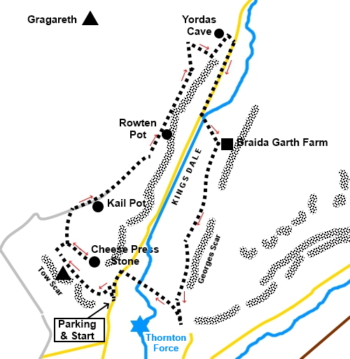
To view route as a dynamic Ordnance Survey map click here. Introduction: Kingsdale is one of the more remote Yorkshire Dales, little visited. A road runs along its length connecting Thornton-in-Lonsdale with Dentdale. Towering above to the north west, at the start of the walk is Gragareth, at 2060ft (627m) the highest hill in Lancashire and with its famous “Three Men” and visited on my Three Men of Gragareth walk. To the south west is the iconic Ingleborough. Kingsdale Beck runs along Kingsdale but this was bone dry at the time of my visit. In this part of the world, because most walkers are either rushing to climb Gragareth or Ingleborough, few people give Kingsdale itself much thought. This is a shame because it is an interesting valley in its own right. It contains various potholes, some of which you can see only the entrances for safety reasons but also Yordas cave which you can enter if you have a torch with you. The valley also has some stunning limestone scenery in the form of limestone pavement, scars and the Cheese Press Stone, no doubt dumped here by a glacier Yordas cave has a large entrance and is safe as long as the main chamber is not waterlogged and as long as you have a torch to avoid tripping. From the 18th Century, it was a show cave until about the end of the 19th Century. At the rear to the right hand side, is a waterfall which is as far as you can go without a specialist potholer’s knowledge and equipment. On this route to Yordas Cave, you will pass a couple of other potholes, Kail Pot and Rowten Pot, both out of bounds to non potholers but interesting to see - and hear! On the return journey, there are spectacular limestone scars lining the valley. The walk starts from a lay-by in Kingsdale. To get there, turn off the A65 near Ingleton into the hamlet of Thornton-in-Lonsdale. In the centre of the hamlet, take the road to Dent. After passing a road junction on the left, continue for a further half mile. The lay-by is on the left. Park here and the route starts from the gate next to the lay-by (SD691757). There is an old quarry with a small stone building next to it. Start: Follow the obvious track from the lay-by, through the gate. Pass through a second gate and stay on the track as it curves right, then left to a coll, passing some large limestone outcrops. As you get to the coll, the ground levels out. Bear right.
You come to a distinct “bowl” in the landscape, between rocky outcrops. As you get to the top of the bowl, the main path curves left but take a fainter path to the right to visit the Cheese Press. The path is faint and indeed there are one or two “paths” or possibly sheep tracks. The best advice is to keep the unmistakable Ingleborough ahead of you.
You will eventually come to the large boulders which are the Cheese Press and a fair amount of limestone pavement with its “clints” (the limestone blocks) and “grikes” (the fissures between the blocks).
From the Cheese Press, retrace your steps to the main track at the top of the “bowl” and turn right. Follow the path until you reach a broad track at a wall and turn right along it. This is Turberry Road, used at one time to transport peat to warm local houses. About fifty yards after the track turns away from the wall, look out on the right for Kail Pot, surrounded by barbed wire (SD688769). There is a stile but you are strongly advised not to cross it!
Continue along Turberry Road and just short of a mile after Kail Pot, on the right of the track and very close to it, is one entrance to Rowten Pot. It is likely you will hear the water rushing down it before you realise what it is (SD698780). Further to the right is a second, larger entrance. Once again, do not get too close. This is for experienced potholers.
Shortly after Rowten pot along Turberry Road, go through a gate, passing a sheep pound. The route is fairly flat but starts to climb to a wall. where there is a gate and a ladder stile. Do not cross the stile but turn right downhill to the right of the wall.
Part way down the hill, you need to cross this wall. The best place to do this is at a distinct line of rock, a small cliff if you will (Shout Scar), where the collection of rocks makes it easy to step over the barbed wire. Head for the trees. When you get to the trees, turn right as if to circle anti-clockwise around them. You will come to a gate (SD 706791). Turn left through it and the entrance to Yordas Cave is obvious.
Inside the cave, it is easy to find your way with your torch. Bear right until you come to a “window” on the left, through which you can see the waterfall. Do not try to go any further but retrace your steps and head downhill to the road. Before the road are a few useful rocks, should you want to stop for a picnic. Turn right along the road for about half a mile and turn left over a ladder stile following a public footpath fingerpost for “Scar End 1¾ miles”. Cross the footbridge and bear right at about 45° to the wall, indicated by a public footpath arrow, heading for the farm you can see (Braida Farm).
Aim for the wall well to the right of the farm’s access track, where the field rises to a high point and where there is a stone step stile. Cross it and bear left following the public footpath fingerpost. Pass along the right hand side of the barn and at its end, turn left then right to the farm.
As you get to the farmhouse, turn right through a walkers’ gate then immediately left following the public footpath fingerpost. In the left hand corner of the field, cross a stone step stile and bear slightly left indicated by the yellow arrow. At the far side of the field, cross a step stile and continue parallel with the trees. In line with the end of the trees, cross a ladder stile then bear left to follow a clear footpath. There are the remains of an old lime kiln on the left.
Cross this large field and cross another step stile. The path is then parallel with the wall.
A series of stiles and well trodden turf lead you to a broad rack. Turn left. The large Skirwith Quarry is ahead. Follow this broad track until you descend to join another and turn right. When it splits, with a narrow descending path on the left, keep to the higher track – although you could take the lower path for about a quarter of a mile to see Thornton Force if you wished. The lower path becomes the Ingleton Waterfalls Walk, for which there is normally a charge.
Stay on the upper broad track down to a stream. Cross via the footbridge and continue to the road. Turn left back to the parking. If you need to buy any hiking equipment/clothing before your trip see the Hiking Store All information on this site is given in good faith and no liability is accepted in respect of any damage, loss or injury which might result from acting on it.
| | |||||||||||||||||

.jpg)
.jpg)
.jpg)
%20View%20along%20Kingsdale.jpg)
%20Approaching%20the%20Cheese%20Press%20Stone.jpg)
%20Cheese%20Press%20Stone.jpg)
%20Limestone%20pavement.jpg)
%20Kail%20Pot.jpg)
%20First%20entrance%20to%20Rowten%20Pot.jpg)
%20Second%20entrance%20to%20Rowten%20pot.jpg)
%20Second%20entrance%20to%20Rowten%20pot.jpg)
%20Looking%20back%20down%20Kingsdale.jpg)
%20Entrance%20to%20Yordas%20Cave.jpg)
%20Entrance%20to%20Yordas%20cave%20from%20inside.jpg)
%20Waterfall%20in%20Yordas%20Cave.jpg)
%20The%20dry%20Kingsdale%20beck.jpg)
%20Old%20Limekiln.jpg)
%20Scars%20in%20Kingsdale.jpg)
%20Georges%20Scar.jpg)
%20View%20to%20Lancashire.jpg)