
|
|
|
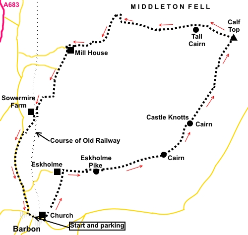
To view route as a dynamic Ordnance Survey map click here. Introduction: Calf Top was promoted to mountain status in 2016 when precise re-measuring decided it was 609.606 metres high, a fraction of an inch over the magic 2,000 ft. If you do the maths, your answer depends very much on roundings and the number of decimal places but it was enough to secure the new designation. The latest OS map rounds the height to 610 metres. The other major change, from 1 August 20016, has been the extension of the Yorkshire Dales National Park which has appropriated Calf Top and Barbon village into its portfolio. I have listed the walk under Cumbria and the Yorkshire Dales. As a mountain peak, it is not an especially impressive top, except that from its summit, there are wonderful views across the Yorkshire Dales to Whernside, Ingleborough and Dentdale, across to The Howgills and if sufficiently clear, to the Lake District. There are also attractive views of the Lune Valley on both ascent and descent. A good proportion of the walk is across the Access Land of Middleton Fell where no specific public footpath routes are shown on the map but on the ground, the way was reasonably clear. Terrain is grassy and with a very steep ascent not far after the start. The GPX route is based on the route actually walked. The walk starts from the War Memorial road junction in the centre of the pretty village of Barbon. There is a small amount of roadside parking by the phone box where there is a bench to aid boot changing. Barbon lies east, off the A683, Kirkby Lonsdale to Sedbergh road, just north of the hamlet of Casterton and is signposted. Start: From the War Memorial ‘T’ junction (SD 629825), with the memorial at your back, turn right along the road, following the road sign for Dent.
Pass the Barbon Inn and St Bartholomew’s Church but immediately after the church, turn left following a public footpath fingerpost (SD 630824), along a broad tarmac track.
At a sharp right hand bend in the drive (SD 832826), there is four way fingerpost, turn left to follow “Eskholme”. The path follows the right hand boundary of the wood directly ahead, with the wall on your left. Go through a farm gate and continue straight ahead, only as far as the farmhouse (Eskholme). As you draw level with the farmhouse (SD 624833), turn 90° right. There is what looks like the remains of an old wall heading up the field. Keep to the right of this and go through a gate at the top of the field. You are now on Access Land and free to wander where you like. The route is a very steep ascent straight up the hill and I went to the left of the larger crag above. Just past this, you will see another crag topped by a stone cairn, which is Eskholme Pike (SD 640833). There are good views here back over Barbon.
The worst of the climb is now over and the route climbs more gently. The route, clear on the ground, does not entirely follow the footpath route drawn on the OS map, which looks to have just been done with a ruler from Eskholme. However, after the climb, you will no doubt be happy to take the line of least resistance!
The route climbs to another cairn (SD 652836) then to a second (SD 657842). The leeward side of this second cairn provided a sheltered lunch stop.
From the second cairn, the path drops gently, then rises to meet a wall. Continue in the same direction, with the wall on your right, to the trig. point. During this section, there are good views to Whernside and Ingleborough and down into Barbondale. At the trig point, there are great views of The Howgills and I could just see white tops of The Lake District hills through the clouds. On a clear day, they would no doubt be spectacular.
At the trig point (SD 665856), with the wall directly behind you, walk straight ahead, roughly north-west, along the top of the ridge (290°). At the time of my visit, there was a clear trodden route. The path passed to the right of two small tarns. I am not sure whether these dry up in summer. You will soon have sight of a tall stone cairn, some eight feet high (SD 658858). The path is several yards to the right of this and its purpose is not clear. By now, the path has become a broader track created by vehicles.
Arrive at another stone cairn, from which there are great views along the Lune valley. The track drops down to the left of this cairn, then bears right. Follow the track down to Mill House (SD 635855).
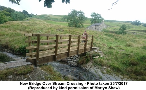
Here, I must confess to having been faced with a quandary. There was a broken notice on the outer of two gates. The top half said “Private” but the bottom half indicated a footpath. The centre section was missing. Ahead are two cottages (holiday cottages I think). The ongoing route is via a public footpath, immediately left, by the right hand cottage, a distance of only a few yards, so I progressed through the gates. Incidentally, my (brand new) OS map has a green spot at this point which indicates public access. If there was an alternative way, I did not see it. If anyone spots another way, please let me know. # See below. Turn left alongside the right hand cottage, following a public footpath sign for “Fellside” and “Borwens”. Note you cannot see this fingerpost until you have turned the corner. Almost immediately, after a stile, you have to cross Millhouse Gill. A new bridge has been provided at some point since I braved the torrent, across gravel and slippery rocks!
Over the gill, keep straight ahead, heading for the gable end of a barn. At the barn, turn right briefly along a gravel track. A few yards further on, go left through a walkers’ gate, then bear slightly right heading for the farm ahead. Go through a slit stile and keep to the left of the farmhouse, going through a farm gate marked with a yellow arrow. Follow its direction. As the farm drive curves right, go through a walkers’ gate, then right through a farm gate and follow the wall on the left across three fields. When your way is barred by a wall in the third field, turn right to follow it, passing a barn a little further on. Turn left through a gate to cross the field diagonally towards Sowermire Farm by the old railway embankment. Follow the track to the left of the railway embankment and go through the tunnel under it (SD 830843). Walk up to the farmhouse then turn left along the drive. As the farm drive turns right, branch off let following the fingerpost for “Borwens”. Cross a footbridge, then bear left at about 45°.
As you crest the rise, you will see Borwens farm directly ahead. Go through a gap in a dilapidated wall, where there is a post with a yellow arrow. Ignore the onward path to the farm and turn right here to go through a narrow walkers’ gate to the road (SD 627840). Turn left to follow the road back to Barbon. # Important: Before undertaking this walk, please read this Annex If you need to buy any hiking equipment/clothing before your trip see the Hiking Store All information on this site is given in good faith and no liability is accepted in respect of any damage, loss or injury which might result from acting on it.
| | |||||||||||||||||

.jpg)
.jpg)
.jpg)
%20Centre%20of%20Barbon%20with%20War%20Memorial.jpg)
%20St%20Bartholomews%20Church,%20Barbon.jpg)
%20View%20towards%20Eskholme%20Pike.jpg)
%20Crag%20referred%20to%20in%20text.jpg)
%20View%20along%20Lune%20Valley.jpg)
%20View%20from%20Eskholme%20Pike%20over%20Barbon.jpg)
%20Wildlife.jpg)
%20View%20over%20Crag%20Hill%20to%20Whernside%20and%20Ingleborough.jpg)
%20Calf%20Top%20Trig%20point%20and%20the%20Howgills.jpg)
%20Telephoto%20Shot%20to%20Lake%20District.jpg)
%20View%20to%20Dentdale.jpg)
%20Stone%20cairn%20on%20Middleton%20Fell.jpg)
%20Lune%20Valley.jpg)
%20View%20back%20to%20Middleton%20Fell.jpg)