|
Annex
to Calf Top Walk and Leaving Access Land at Mill House
Link to Calf
Top Walk
I worked out this route
from the OS map from Barbondale to Calf Top in 2017. For the return, I
followed a clear track over Access Land leaving it at Mill House (see map on
the walk page).
There was a broken notice on the fell side of two gates at Mill House.
The top half said “Private” but the bottom half indicated "footpath".
The centre section was missing. Ahead were two cottages (holiday cottages I
think). The ongoing route is via a public footpath, immediately left, by the
right hand cottage, a distance of only a few yards, so I progressed through
the gates. Incidentally, my (brand new at the time) OS map has a green spot
at this point which indicates public access (See update note below dated 2
March 2026). If there was an alternative way
indicated, I did not see it.
On 25 May 2020, a user of this route reported what looked like a new
notice affixed to the gate on the fell side of Mill House. See picture
below, provided by a later walker.
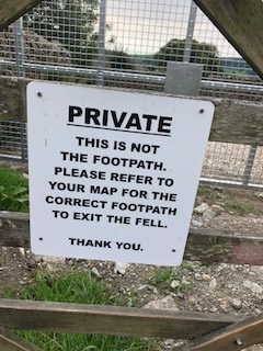
Photo provided by a walker
on 30 August 2022
I have seen signs at
locations before, where there seems a conflict between "Private"
and "Footpath" but in this case, the addition of the reference to
using a map to find an alternative route indicates pretty decisively that the landowner does not
want you using this means of egress from the Access Land, however short.
Unhelpfully, it does not state how or where egress might be achieved.
This request seems to
conflict with the green spot on the OS map which suggests egress/access is
allowed.
Not using this route at
Mill House presents a problem because if you look at the OS map, leaving this Access Land
via a clearly marked Right of Way
in this area cannot be done without a long detour and it is unlikely that
anyone who gets this far will be of a mind to retrace their entire steps over the
same route back to Barbon. Anyone just picking up an OS map and working this route out for
themselves, as I did, has no way of knowing about this problem in advance.
According to The Ramblers,
"You are permitted to climb over walls or fences to get into, out of,
or across open access land, as long as you don’t damage them.".
However there is no mention of a situation like this, where there is no
Right of Way immediately alongside a potential egress point.
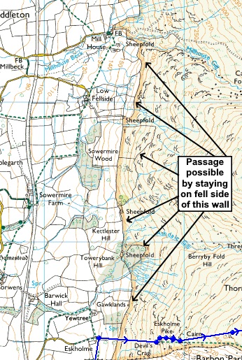
3 April 2022, a user of my route reported getting as far as Mill House. The
notice referred to above is still there and as there were people about, he
did not want to risk my original route. He found by following the wall
indicated on the map below, he got back to the footpath from Eskholme without
any problems, though he did have
to
climb up a bit. Looking at
the aerial photo, there does seem to be a path worn on the fell side of the
wall.
The path from Eskholme is the one used on the outward journey of my walk (in
blue on the map below), so a return to
Barbon is then a case of retracing your steps from there.
Pending any better
information or input from the Yorkshire Dales Footpath Officer, this looks
like the only way to go, to avoid any conflict at Mill House. The
alternative is to return directly from the Calf Top summit to Barbon.
The matter was referred to the
Yorkshire Dales Footpaths Officer in 2020 following the first report in but
other than an acknowledgement, I have heard nothing further. No doubt COVID
has played a part. I have sent a reminder. A further request for an update
was sent on 31 August 2022, with the response that the matter would be
considered later this year when other projects were completed.. I will report any updates here.
I did some additional research on the Natural
England website to try to cast some more light on the Access Land situation
at Mill House and this can be seen here.
21 February 2023
I have been approached by a Mark
Braithwaite, a resident near to Mill House who believes there should
be a right of access to/from the fells at Mill House. He is applying for a Definitive Map Modification Order
(DMMO) and is anxious to receive information from any one who used this
route anytime earlier than 2010 or if anyone had used it without challenge.
If you can help, please contact him directly at braith8@hotmail.com.
He has confirmed he is happy to
have his details published.
28 May 2023
I have been approached by the
owner of Low Fellside. He confirms there is no egress from the Access Land
via Low Fellside and in fact to do so, you would have to trespass on both
his land and someone else's. Any previous information you may have seen on
here about egress via Low Fellside (now deleted) should be ignored. He also
confirmed that the
Yorkshire Dales Footpaths Officer is actively trying to get an egress route
agreed elsewhere, as he has met him but no further details are known.
Incidentally, not that it
affects this egress issue, there is a road shown on OS maps as a public road
to Low Fellside and theoretically linking up to the north/south Right of Way
from Mill House. The owner tells me this is not in fact a public road. The
OS map is incorrect and the Ordnance Survey are supposed to be correcting
it.
2 March
2026
I wrote to Ordnance Survey
regarding the misleading green 'blob' at Mill House which leads to people
assuming there is access to/from the fell at that point. They have agreed to
remove it and just continue the green footpath dashes from Tossbeck along
the short section of road and connect with the continuation to Low Fellside
though were not specific as to when the update will occur. No information on
any 'official' alternative exit strategy from the fell.
All information on this
site is given in good faith and no liability is accepted in respect of any
damage, loss or injury which might result from acting on it.
|


.jpg)
.jpg)
.jpg)