
|
|
|
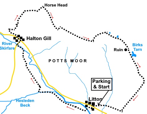
To view route as a dynamic Ordnance Survey map click here. Introduction: Having walked over the neighbouring Firth Fell previously, during my Buckden to Starbotton walk, I was aware of Birks Fell but this was my first trip along it. Perhaps foolishly, I chose to do it on one of the hottest days of the year, which may have coloured my judgement but it was a hard walk. However on the plus side, there are fabulous views of the very beautiful Littondale, of all of the Yorkshire Three Peaks and across Wharfedale to Buckden Pike. Another plus was the quiet nature of the walk. I did not see any other walkers between leaving and returning to Litton. Clearly the ridge is not well walked, though I believe it has become more popular since it was relatively recently elevated (literally?) to the peerage of being a ‘Marylin’ (a hill with a height of at least 150 metres (492 ft) relative to its surroundings) following a recount! In most places, a faint path was discernable. Even where a path was not clear, navigation is very simple. Once on the summit, there are no public footpaths shown on the map. It is Access Land so you can wander where you like but the ridge walk follows a combination of wall and fence lines which are pretty self evident. There are three tarns along the summit but only Birks Tarn seems to be named. It is the terrain which makes it hard and I think you have to accept that you could find it challenging. There is a steep three quarters of a mile climb from Halton Gill, straightforward in itself but it is the surface along the ridge which is the problem. It has a mixture of ‘groughs’ (deep gullies in the peat) and peat ‘hags’, a little reminiscent of Kinder Scout, in the Derbyshire Peak District. I did the walk after a dry spell but I would not recommend doing it route after a wet spell. There would clearly be some extremely boggy sections, hence the amber rating, even though the surface is not hilly. The steep pull up from Halton Gill also warrants amber. The ridge is between Littondale and Wharfedale and at 2001ft (610m), is the highest point between the two dales. Littondale is very pretty whereas Wharfedale is attractive in a more rugged way. The river Skirfare runs along Littondale and is often dry, as it was on this walk, when the reduced water flow disappears under the limestone. There are quite a few listed buildings in the village, not least Litton Hall, which dates from the 18th century. The pub, the Queens Arms also dates from the 18th century and is recommended for its beer/food. The village was infamous for cockfighting and badger baiting in the 17th and 18th centuries! Halton Gill also has a number of old buildings, also dating from the 18th century. The walk starts from the lovely village of Litton (not to be confused with Linton!), opposite the Queen’s Arms pub.. Parking is on street. To get there, turn west off the B6160 between Threshfield and Kettlewell, signposted for Arncliffe and Litton and follow the road and signs to the village. Start: The walk starts opposite the Queem’s Arms pub in Litton, where you take the track indicated by the fingerpost for “Bridleway” and “Ford”. The river was bone dry when I did the walk but if by any chance the ford is impassable, there is a footbridge only about two hundred yards upriver
At a ‘T’ junction of tracks, turn left to the ford and cross.
Just after the ford, ignore a fingerpost to the left for “Arncliffe” and follow footpath signs for “Nether Hesleden”. You arrive at a three way fingerpost. Continue to follow “Nether Hesleden” but as a matter of interest, the direction of the finger pointing to “Litton” is the way you would come from the footbridge.
At another junction of tracks, where the right hand arm goes over a hump back bridge, keep straight ahead. You reach another three way fingerpost. Here, branch right, off the main track, again following “Nether Hesleden”. Head for the far right hand corner of the field and through a gate. Walk along the top of the banking, once again to the far right hand corner of the field. Follow the obvious path across several fields, eventually adjacent to Hesleden Beck, until you reach the bridge over it at Nether Hesleden. Cross the bridge and turn right. After a hundred yards or so, branch left on to a footpath. Follow this obvious footpath, initially parallel with a row of trees on the right, then across several fields (I think about 10/11). You will pass several barns, all to the left of you. Emerge on to the road next to the bridge at Halton Gill. Turn right and at the road junction, turn left through the village, following the road sign for “Foxup ¾ mile”. Just past the last property in the village, turn right along a clear track with “No vehicles except for access” signs and a fingerpost “Route to Yockenthwaite 3 miles and Beckermonds 2½ miles”. You now have a steep climb of three quarters of a mile until you reach a gate which is Horse Head Gate. Just beyond is a sign for “National Trust Upper Wharfedale” (SD 889776).
Go through this gate and turn immediately right to follow the small path alongside the wall. You are now on Access land. This wall and subsequent walls/fences are basically your guide but I give a few waypoints. As you get to a fence, the path swings left to follow it (SD 895769) then quickly right at its corner. At SD 898768, I crossed over the fence to avoid having to cross several other bits of fencing but essentially, whichever side of the fence you use, the important thing is to follow it as closely as the terrain will allow. At SD 904765 you meet a wall. You now need to be on the left of the fence (North side) and follow it, with it on your right. Arrive at a walkers’ gate. Through this, continue to follow the wall. At SD 907674, meet another wall. Turn left to follow this - right at the corner.
The wall gives way to fence then reverts to wall. Keep following it, going through a kissing gate.
Round about SD 913767, you pass a small tarn to the left (difficult to spot) and at SD 915765 another. Neither of these are shown on the OS map and are not named but as I did this walk after a long dry spell, I assume they must always be there. They are visible on satellite photos.
Continue
following the wall, through another walkers’ gate. At SD 919761 you pass the remains of an old building (shepherd’s hut?). You are now within sight of Birks Tarn, which is shown on the map.
At SD 925750 you meet a footpath which is flagged with stone slabs. In the near distance, you can see the trig. point on Firth Fell. This is the main Buckden to Litton bridleway. Turn right and follow it to Litton. It is a simple route to follow, though there are one or two quite steep sections. The way needs no further directions.
If you need to buy any hiking equipment/clothing before your trip see the Hiking Store All information on this site is given in good faith and no liability is accepted in respect of any damage, loss or injury which might result from acting on it.
| | |||||||||||||||||

.jpg)
.jpg)
.jpg)
%20A%20view%20of%20Litton.jpg)
%20Another%20view%20of%20Litton.jpg)
%20Ford%20at%20Litton.jpg)
%20View%20up%20Littondale.jpg)
%20Arriving%20at%20Horse%20Head%20Gate.jpg)
%20View%20over%20Wharfedale.jpg)
%20An%20example%20of%20the%20terrain%20on%20Birks%20Fell.jpg)
%20Unnamed%20tarn%20on%20Birks%20Fell.jpg)
%20Ruin%20on%20Birks%20Fell.jpg)
%20Birks%20Tarn.jpg)
%20Trig%20point%20on%20Firth%20Fell.jpg)
%20View%20on%20the%20descent%20to%20Litton.jpg)