|
Buckden
to Starbotton via Firth Fell
Starting point and OS Grid reference:

Buckden
- pay and display car park (SD 943774)
|
Ordnance Survey Map
OL
30 Yorkshire Dales – Northern and Central Areas.
Buy
this map from
List
of OS Maps
Note: If you use OS Maps on-line, you can download this route via this
link.
| |
Distance: 7.9 miles
|
Date of Walk: 21
November 2014
| |
Ascent:
Descent:
See Walking Time Calculator
|
1448ft (441m)
1438ft (438m)
| |
Traffic
light rating: 

(For explanation see My
Walks page)
| |


For advice on .gpx files see
My Walks page
|

Click
the PDF logo above to give a printable version of this walk without the
photos.
|
To
view route as a dynamic Ordnance Survey map click here.
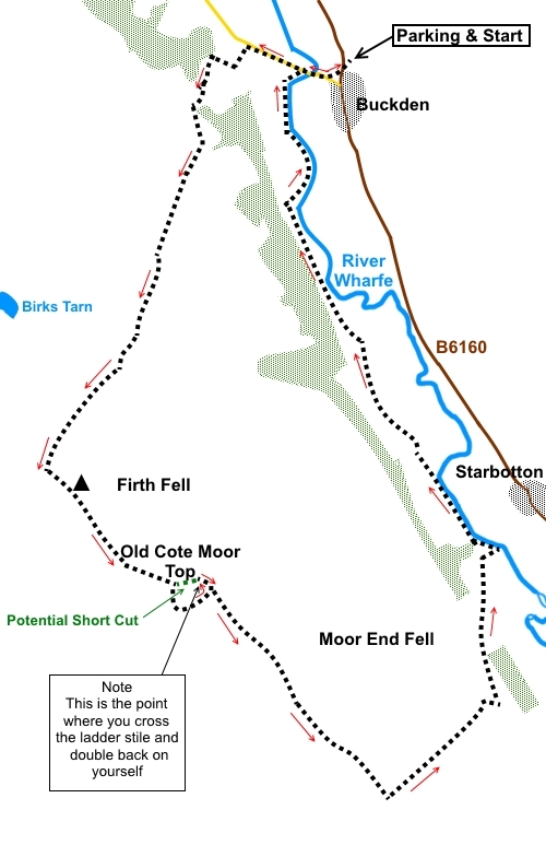
Introduction: This
Wharfedale walk from Buckden to Starbotton via Firth Fell takes you along
the ridge separating Wharfedale from Littondale. It offers great views over
and along both valleys including to Buckden
Pike.
The
route along the top of the ridge is not marked as a footpath on the OS map
but this is Open Access Land, so you are allowed to walk it and there are
stone walls to guide you, which provide easy navigation.
You
pass a trig. point on Firth Fell at 1991 ft (607 metres).
The
first section of the walk to the top of the ridge is quite steep –
borderline red/amber so I have given in a red. My route on the ascent is
slightly straighter than the OS map indicates but is based on the track I
recorded on my GPS receiver as I followed the obvious path. The route along
the ridge can be a little boggy after wet weather and in these conditions,
gaiters are recommended.
There
are theoretically refreshment opportunities at the Fox and Hounds pub in
Starbotton but it has never been open when I have passed, so I would phone
to check before you rely on it. Otherwise, this is a pretty village worth a
quick look for its own sake. You will probably pass through it en route to
Buckden.
The
walk starts at a pay and display car park in the pretty village of Buckden.
There are toilets here. To get to Buckden, head north out of Skipton on the
Grassington road (B6265). At Threshfield, ignore the right turn to
Grassington and continue ahead, now on the B6160 to Buckden. The car park is
through the village on the right (SD 942773).
Note:
It was a misty autumnal day when I did the walk so to give a clearer
indication of what you might see, I have “cheated” and used some photos
from part of the same route from an earlier occasion.
Start:
From the car park (SD 943774), turn left along the road and
immediately right on a wide stony track. At the next road (which is to
Hubberholme), turn right.
Cross
the bridge over the River Wharfe (known as the “Election Bridge”, as an
MP promised to fund it if elected, to replace an earlier one swept away) and
a quarter of a mile further on, turn off the road on to a broad bridleway
following the fingerpost “Public Bridleway to Litton 3½ miles” (SD
937775).
%20View%20up%20Wharfedale%20near%20Buckden.jpg)
%20Looknig%20back%20towards%20Buckden.jpg)
There
are a couple of places as you climb where the track splits off to the right
but keep to the main track heading up the hill.
Eventually,
go through a gate by some animal pens, staying on the main track.
Just
before some trees, the path divides. Turn right to follow the public
bridleway fingerpost. For a while, some posts with blue tops mark the route.
You will notice the ruin of a fairly complete ruin to the right. As
you come level with it, there is a track going off to the right but ignore
this and keep straight ahead.
As
you get closer to the ridge, there is a “manicured” stretch of path with
laid flagstones, then a series of stone cairns. Follow this clearly marked
route eventually passing through a gap in a stone wall (SD 925751) and
turning right to follow the wall. After a short distance, the path curves
off to the left.
Follow
the path to a gate (SD 925750) but do not go through it. Instead, turn left
to follow the wall, passing the trig. point (SD 926748) of Firth Fell and
leading eventually to a ladder stile at (SD 934743). The wall has a number
of turns. You can stick with the wall until you get to the stile which is a
distance of 0.9 miles or, at Old Cote Moor Top, you could cut off to head
E.N.E. (76° magnetic). This cuts off a corner but this only saves about 0.2
of a mile. If you follow the wall, you have less danger of going wrong.
%20Trig%20point%20on%20Firth%20Fell.jpg)
Cross
the ladder stile and turn right to follow the wall, effectively going back
on yourself. The stone wall here is not in good condition and I do not
recommend trying to short cut by climbing over it because of the obvious
risk of collapse and injury.
From
the ladder stile, follow the wall along for just over a mile, passing some
deeply eroded rocks, until you meet the bridleway (SD 945730) which comes up
from Arncliffe and over the ridge to Starbotton. This is a clear, well used
path crossing at 90° and you should not have any problem spotting it. Turn
left.
%20Eroded%20rocks.jpg)
Follow
the path downhill. After a short steep section, there is a two way
fingerpost. Keep straight ahead following the fingerpost for “Public
Bridleway Starbotton”. Shortly after the fingerpost, just beyond the end
of a stone wall, turn right to a walkers’ gate. Go through this and head
down the path for Starbotton which you can see below, slightly to the left.
%20Looking%20down%20on%20Starbotton.JPG)
%20Meanders%20of%20the%20Wharfe%20near%20Starbotton.JPG)
%20Looking%20along%20to%20Kettlewell.JPG)
The
path descends via an old section of moss covered, walled path to the river
by a footbridge (SD 951745). You can cross the river to Starbotton if you
wish to have a look but otherwise, turn left to follow the fingerpost for
Buckden.
%20Walled%20path.jpg)
The
path running along the valley bottom is clear and runs more or less parallel
with the river although the river meanders and is not always next to the
path. Follow the path for a mile and a half and at SD 939765 turn right at a
two way fingerpost showing the Dales Way in each direction. In effect, it is
the first right turn you come to.
At
the road, turn right to retrace your steps to Buckden.
If you need to buy any
hiking equipment/clothing before your trip see the Hiking
Store
All information on this
site is given in good faith and no liability is accepted in respect of any
damage, loss or injury which might result from acting on it.
|


.jpg)
.jpg)
.jpg)