
|
|
|
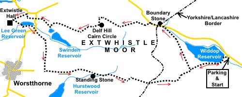
To view route as a dynamic Ordnance Survey map click here. Introduction: This walk in Pennine country starts in Yorkshire but the majority of it is in Lancashire. It starts from Widdop Reservoir and rambles over Extwistle Moor to visit the sad ruin of Extwistle Hall. During the walk, you see several of the reservoirs which proliferate in these parts and Delf Hill Cairn Circle, though to be fair, it is not particularly exciting. There are however some interesting rocky outcrops. The walk seemed more demanding than the terrain on the map suggested and it is strongly recommended that you wear gaiters as there were some wet sections, although this was winter. Although there were no particularly steep ascents, meaning I would normally have rated the walk as all green “traffic lights”, I have unusually graded part as amber because of a section across “tufty” ground and a very long pull of some two miles from near Worsthorne, along Gorple Road (track). There is about a quarter of a mile section of road walking but the road is very quiet and you are rewarded at the end of it with a spectacular view. The “tufty” ground section will also give you an interesting navigational challenge! Widdop reservoir was constructed by the Yorkshire Water Board (as they then were), completing in 1878. Looking up the reservoir from the car park are a number of distinctively shaped rocks known as Cludders Rocks. Although a Grade II listed building, Extwistle Hall is a sad neglected property which at one time must have had great status. The first part of it was constructed in 1585. It was the victim of a major fire in the early 18th Century, then remodelled later that century. It has not been occupied since 1975. It is listed on the Heritage at Risk Register by Historic England as being of “special architectural or historic interest”. At the time of my visit, it was up for sale. Somebody had better be quick! The walk starts from a free car park at Widdop Reservoir. The easiest way to describe getting there is from Hebden Bridge. Turn off the A646 at the traffic lights by the Fox and Goose pub, on to Heptonstall Road. Note if travelling east to west, you cannot turn right and have to use a “turn round” a short distance further on then come back to turn left. Continue along Heptonstall Road (which changes name a few times) for about two miles and turn right to follow the road sign for Widdop 4 miles and Colne 9 miles. Look out for the Packhorse Inn. The car park is just over a mile beyond. Refreshment
facilities are potentially available at the Roggerham Gate Inn (postal
address at Briercliffe) but check opening availability. Alternatively, there
are some steps you could sit on for a picnic at Lee Green Reservoir. Start: Walk along the short path from the car park to the reservoir and cross the dam. At the far side, turn right to follow the obvious track, climbing above the reservoir. You are following the Burnley Way.
When the track turns sharply left (SD 927324), you turn right on a much smaller path, by a marker post with blue bridleway and yellow footpath arrows. Quickly cross a single stone bridge. The path curves round the head of the reservoir. At a two way fingerpost, keep straight on following “Road” and “County Boundary”. After passing to the left of a couple of small weirs, the path crosses the stream and follows its right hand bank, at a higher level. At the road, turn left. Pass a boundary stone marking the Yorkshire/Lancashire border (SD 918337), with an arrow carved it its top. Also a sign for “Briercliffe with Extwistle”.
As you get to the brow of the hill, you are rewarded with a fine view to Pendle Hill, a view which predominates for much of the walk. On the right is a broad gated track. Here, turn left off the road on to Extwistle Moor, by some large rocks, to follow a footpath which curves gradually right (SD 918337) and leaving the Burnley Way.
Proceed through a kissing gate, where there is a three way fingerpost. Keep straight ahead, following “Pennine Bridleway, MT Loop, Gorple Road 1¼ miles”. A few yards after the fingerpost, look out for a faint path off to the right, crossing the open land (SD 907337). This is easy to miss. Even worse, not far from the turn, the clearly, little walked, path becomes invisible amongst the tufts of grass. However, you have a splendid waymarker ahead of you in the shape of Pendle Hill! Keep in line with the steep, right hand slope of it. Alternatively, practice your compass skills and head 290° magnetic. You drop down a steep banking and up the other side and as you crest the second rise, you will see a stone wall to your right. If you look left along it, you will see another wall comes in from the left to join it at 90°. Aim for this corner where there is a stile. Cross it and turn immediately left to follow the wall, now leaving official footpath routes and making use of Open Access Land. After no more than two hundred yards, you arrive at Delf Hill Cairn Circle.
As you look across it with the wall behind you, you can see the trig. point. Head to this and continue in that same direction to the old quarry. The old spoil heaps soon become visible. Follow the main track down through the centre of the quarry to a gateway at its far side. The ground is a bit churned up by motorcycles/quad bikes or whatever. Just keep a more or less central course. The gateway had a crude barrier of scaffold poles and wire fencing which I climbed over, to follow the old quarry access track. If you do not want to do this, turn left and follow the wall for about two hundred and fifty yards until you reach a public footpath route and turn right. Both ways finish up at the same place, above a small, almost rectangular reservoir.
Before getting to the tarmac lane, cross a stone step stile to the right of a copse of trees, with a yellow arrow. There was also a large container when I passed and the stile was to the right of this too. The path goes through some trees and over a stream via a bridge which was very dilapidated, with missing sections. Just after this, bear left following a public footpath sign and yellow arrow, then bearing right up a banking, to follow a wall past some houses. Follow the access drive over a cattle grid by Holden Barn. Stay on it to the road and go straight across to climb a stone stile. Head for a gate to the right of the farm buildings, then turn right to follow the broad track. At Proctor Cote House, by the road, turn left to follow another track (not the road). Along here you will soon come across Extwistle Hall but before viewing it, look out for a stile on the left just before it, with a yellow ‘B’ marker, which is your onward route, rejoining the Burnley Way.
Follow the path down the field to Lee Green Dam and cross. There are some concrete steps here which make a handy picnic stop. Note the stile to access the dam is to the left of the gates, just round the corner. Walk anti-clockwise round the dam and at the road (where you will see the pub to the left) turn right for a mere one hundred yards where, as the road turns sharply right, you turn left to follow a broad track marked with a public footpath fingerpost. Note there is a footpath going sharp left here too which you ignore. Almost as you draw level with the overflow from the reservoir, fork off right along a rising track (SD 884334). When the track opens into a large field, go straight ahead remaining parallel with the power lines. At the far side of the field, to the right of some animal pens, cross a stile marked with a yellow arrow and continue straight ahead. Stay on this track, crossing a couple of stiles, until you reach a ‘T’ junction with a broad track (Gorple Road) (SD 885324). Stay on this main bridleway all the way back to Widdop Reservoir.
You pass some strange humps and bumps on the right. These are Cliviger Hushings, the spoils of a process of extracting limestone from the area, by using the force of water to wash away soil and gravel, leaving the limestone rock behind.
At SD 899323, pass a standing stone, from where there is a nice retrospective view. Close to its base is an Ordnance Survey benchmark.
Further on above Gorple Reservoirs, you pass Gorple Rocks, dramatic gritstone outcrops.
At a three way fingerpost, the path starts to descend. In the far distance to the right you can make out the Stoodley Pike monument. Continue descending. You will reach a point where the track bends sharply right and will hopefully recognise the path off to the left which you took near the start of the walk. Stay on the broad stony track back to Widdop Reservoir and the car park. If you need to buy any hiking equipment/clothing before your trip see the Hiking Store All information on this site is given in good faith and no liability is accepted in respect of any damage, loss or injury which might result from acting on it.
| | |||||||||||||||||

.jpg)
.jpg)
.jpg)
%20Widdop%20Reservoir.jpg)
%20Part%20of%20Cludders%20Rocks.jpg)
%20Part%20of%20Cludders%20Rocks.jpg)
%20Boundary%20stone%20marking%20Yorks%20Lancs%20border.jpg)
%20View%20to%20Pendle%20hill.jpg)
%20View%20to%20Lad%20Law.jpg)
%20Delf%20Hill%20Cairn%20Circle.jpg)
%20Delf%20Hill%20Trig%20Point.jpg)
%20View%20over%20Swinden%20Reservoir.jpg)
%20Extwistle%20Hall.jpg)
%20Extwistle%20Hall.jpg)
%20Looking%20down%20Gorple%20Road.jpg)
%20Cliviger%20Hushings.jpg)
%20standing%20stone.jpg)
%20Part%20of%20Gorple%20Stones.jpg)