|
Silsden
to Bradley
Starting point and OS Grid reference:

Silsden
– pay and display car park (SE 042465).
|
Ordnance Survey Map
OL
21 - South Pennines.
Buy this map from
List
of OS Maps
.
Note: If you use OS Maps on-line, you can download this route via this link.
| |
Distance:
7.6 miles
|
Date of Walk:
6 March 2014
| |
Ascent:
Descent:
See Walking Time Calculator
|
836ft (255m)
836ft (255m)
| |
Traffic
light rating: 
(For explanation see My
Walks page)
| |


For advice on .gpx files see
My Walks page
|

Click
the PDF logo above to give a printable version of this walk without the
photos.
|
To
view route as a dynamic Ordnance Survey map click here.
Introduction:
This walk from Silsden provides some
pleasant views en route, over towards Cowling Pinnacle and
Pendle
Hill,
Sharp Haw and Rough Haw and Rombalds
Moor.
Silsden will be a place of mystery for many
as they whiz past the signposts to it, on their way to the Yorkshire Dales
or Lake District, up the A65 or A629 major roads. It is known locally as
Cobbydale, as the "River Cobby", in reality a small beck shown on
the OS map as Silsden Beck, flows through it. It is served by Steeton and
Silsden railway station.
Surrounded by agricultural land originally,
it prospered in the Industrial Revolution, with the establishment of various
mills and the proximity to the Leeds Liverpool Canal. It began in the 1760s
when William West brought the skill of nail making to the town. A sculpture
by the town centre car park celebrates this piece of history. Industry
developed into clog iron making and a thriving textile industry.
The town’s folk are friendly and it has a
fair smattering of independent shops and several pubs.
Bradley is a quiet, tranquil, picturesque
village with two sections, High Bradley and Low Bradley. The best reason to
visit is to enjoy excellent food and beer at the Slater’s Arms!
The return journey is via the Leeds/Liverpool
Canal. A pleasant waterside stroll, if somewhat marred by the drone of
traffic, along the nearby A629.
The walk starts from the main car park in
Silsden (reasonable price). To get there, turn south off the A65 at
Addingham, or north off the A629 at Steeton on to the A6034 and simply
follow it to the centre. Alternatively, you could walk the mile or so from
Steeton railway station.
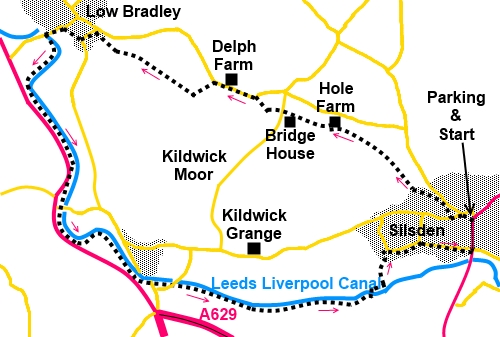
Start:
From the car park (SE 042465), cross the main street (Kirkgate) and walk
along Briggate immediately opposite. At the top, turn left along Skipton
Road and second right, along Foster Avenue (SE 040465) and walk to its end,
passing some garages. Keep on the track straight ahead.
%20Sculpture.jpg)
At a yard full of plant machinery, go through
the footpath gate to its left. Make sure you keep straight ahead and do not
be sidetracked along the left hand footpath. You soon find yourself walking
alongside a beck.
Cross the beck via a little ford (watch out
for slippery stones) (SE 036469) and go through the gate opposite into open
fields, climbing gently. Follow the right hand side of the field as it
follows another beck.
%20Looking%20back%20towards%20Rombalds%20Moor.jpg)
The route passes through a small gate into
the yard of Low Bracken Hill Farm. Cross the yard and fork right, following
the farm drive. As the farm drive bends right, keep straight ahead along the
left hand side of the field (SE 033472).
Cross a stile in the corner of the field and
stay on the left of the field to the next stile. Once over this, keep
straight ahead heading for a white painted house (Hole farm) in the near
distance. As you get to the line of trees by a brook just below the house,
cross a stile and walk up the left hand side of the field to a metal gate on
the left. Go through the gate and turn immediately right.
After a few yards, turn right over a wooden
stile then left around the edge of the hen pen and over another stile. Go
straight ahead now to come out at the road, to the right of Bridge House (SE
024476). Turn right along the road and almost immediately left over a stone
stile indicated by a fingerpost.
Keep to the right of the field, to the far
right hand corner, passing under some power lines. Here, go through a small
walkers' gate and immediately left through another, then go clockwise around
the property (Bloomer Hill Farm House).
Look out for the yellow arrows indicating the
route and go right through a gate. Then, exit the field via a ladder stile
on to the drive, turn left then left again at the road.
Walk along the road for about a quarter of a
mile and just after Delph Feline Retreat, a boarding cattery (Delph Farm on
the map), note the trig. point in the field on the right hand side (SE
017479).
%20Trig%20point%20at%20Delph%20Farm.jpg)
Continue along the road and at the brow are
good views ahead of Sharp Haw and Rough Haw and to the left (SW), Cowling
Pinnacle, with the mass of Pendle Hill behind it. Just past the brow, turn
left over a stone stile to follow the public footpath fingerpost.
%20Looking%20towards%20Cowling%20Pivnacle.jpg)
%20Looking%20NW%20over%20Skipton%20to%20Rough%20Haw%20&%20Sharp%20haw.jpg)
%20Cowling%20Pinacle%20and%20Pendle%20Hill.jpg)
Head for the opposite corner of this field.
Go over the stone stile, turn right and through the gateway, to walk more or
less down the middle of the field, through another gateway and to the stile
beyond in the right hand corner. The edge of Bradley is visible ahead.
%20Approaching%20Bradley.jpg)
Keep to the right hand side of the fields to
the drive to the property Sirebank House, on the left and turn right along
it. At the lane turn left and immediately right over another stile. Bradley
is below you. Aim more or less for the tall chimney you can see, entering
Bradley between two rows of cottages – Sunny Bank. Turn left at the end of
the row, along Main Street.
To get to the Slater Arms, just follow Main
Street as it curves left. Note the last road you pass before the pub
(Matthew Lane) is the continuation of the walk down to the canal.
Walk down Matthew Lane and at the ‘T’
junction, by the mill chimney, turn left. Cross the canal via the swing
bridge and turn left to follow the towpath.
%20Cross%20Lane%20Mill%20Low%20Bradley.jpg)
Walk along the canal, passing Farnhill and
Kildwick. Keep a look out for the memorial to Polish Airmen (SD 999477) at
the next bridge.
%20Approaching%20memorial%20to%20Polish%20airmen.jpg)
%20Memorial%20to%20Polish%20Airmen.jpg)
%20Tranquil%20Transport.jpg)
%20Farnhill.jpg)
Stay on the canal towpath until you reach
bridge 191 (SE 032458). Cross it and turn immediately right following the
public footpath fingerpost. Follow the canal for a short distance until you
come to a tarmac path leading to the moorings. Turn left here.
%20View%20near%20Silsden.jpg)
Cross the broad track to the farm keeping
straight ahead. Come to a stile on the right formed from three slabs of
rock. Turn right here and follow the path slightly uphill to the modern
housing estate at Woodside Road. Turn right. Keep right at the next junction
and follow Vale View and Elliot Street down to Silsden’s main street,
Kirkgate. This gives you a chance to see what Silsden has to offer. Turn
left back to the car park.
If you need to buy any
hiking equipment/clothing before your trip see the Hiking
Store
All information on this
site is given in good faith and no liability is accepted in respect of any
damage, loss or injury which might result from acting on it.
|


.jpg)
.jpg)
.jpg)