
|
|
|
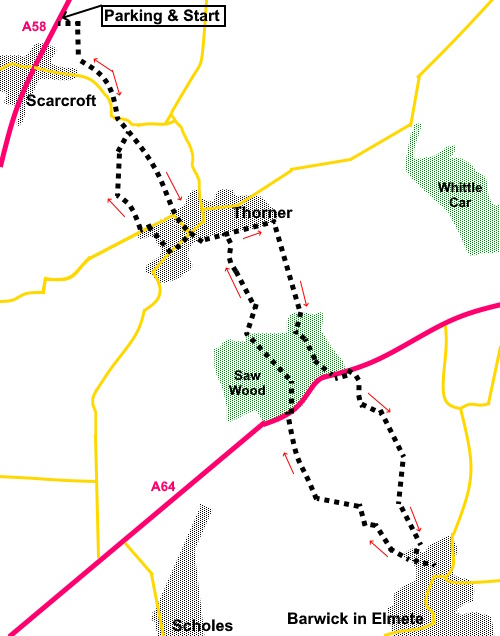
To view route as a dynamic Ordnance Survey map click here. Introduction: This walk follows the Leeds Country Way between Scarcroft and Barwick in Elmet then returns via a different route. The Leeds Country Way as you might expect is well marked and walked, although there are a few places where additional signs would have been helpful. Scarcroft is a village just outside Leeds itself. Its main claim to fame is as home to some of the most expensive housing in the Leeds area and a golf club. It lacks any particular soul in my opinion though does have a pub! The attractive rural village of
Thorner which is registered in the Domesday Book as “Torneure” lies on
our route. St Peter’s Church in Thorner is Grade II listed and some of it
dates from the 15th century. Archaeological evidence
suggests habitation dating back to the Bronze Age. The main area of the
village is a conservation area. Barwick in Elmet (known as Barrick)
and has the “in Elmet” part to identify it distinctly from other
similarly names villages. It has earthworks indicative of a large Iron Age
fort, which became a Norman motte and bailey castle and was even a World War
II observation post. It is famous for its maypole, some 86 feet high. Every three years at Spring Bank Holiday, they have a popular festival. It is taken down at Easter, refurbished and re-erected at Spring Bank Holiday. This is followed by maypole dancing, Morris dancers etc. Once securely erected, the tradition is that someone will try to climb the pole and spin the weathervane at the top. The next scheduled event as I write is 2025. The walk starts from a small lay-by on the A58 just to the north of Scarcroft almost opposite a cul de sac called Wayside Mount. You need to ensure you get the correct spot as there is another lay-by about half a mile further north which looks very similar, more on the outskirts of Bardsey, which is where my Bardsey to Thorner Via Pompocali walk starts. There is a short overlap between the walks. I have not captioned all the photos, some of which were just pleasant views along the way. Start: Follow the footpath from the rear of the lay-by, indicated by the Public Bridleway fingerpost. Immediately after passing under some power lines (only about two hundred yards from the start), turn right to follow the hedge line on the left (SE 369423), initially parallel with the power lines.
After less that a quarter of a mile, cross a footbridge and turn left along the left boundary of the field (SE 368420). Continue following the obvious path, forking off right towards some buildings and turn right along the drive, to the road. Turn left along it. Turn right to follow a public footpath fingerpost, after about three hundred yards. On reaching a farm (SE 373413), turn left along the broad concrete drive and immediately after the last building, turn right following a public footpath sign for the “Leeds Country Way”. The path continues down the middle of a large field to a walkers’ gate at the bottom, passing a three way fingerpost. “Thorner” is your goal.
The path emerges in the village of Thorner. Turn left and follow the road as it curves right. At the Mexborough Arms pub, cross straight over the road along Stead Lane. Follow it past Butts Garth, Claypit Lane and Moat End then, as Stead Lane bends left and becomes Kirk Hills, turn right following a Public Bridleway sign (SE 381404). Ignore a path off to the right which you soon meet. This is your return path. On meeting a lane, turn right (SE 386406). Follow it until you reach a farm gate. Through this, turn right following a fingerpost for the “Leeds Country Way”. Continue following the obvious path until you reach a three way fingerpost. Turn left again following “Leeds Country Way.
Enter Saw Wood and follow the right hand boundary for about two hundred yards then fork left to continue following the bridleway through to the A64. This is an extremely busy road and you need to take great care crossing it. Turn left to the left hand end of the lay-by when. Immediately opposite, across the road, there is a narrow footpath behind the wall which saves walking along the road. Follow this until you reach another footpath and turn right to follow it alongside the stream.
Pass an earth closet toilet for use by campers and shortly afterwards, turn left over an unusual stile. The top pivots upwards to allow easy passage. Follow the right hand side of the field and through a similar stile.
Stay on the path which turns right over a footbridge (SE 397385). Continue following the obvious path, crossing another bridge at SE 398377 and climb the concrete/tarmac track. At the lane turn left into Barwick in Elmet, or, if you do not intend to visit the village, turn right and quickly right again over a stile following a public footpath fingerpost.
Assuming you arrive at the Gascoigne Arms (recommended) and the famous maypole, return the same way to the point mentioned above. After going over the stile, follow the obvious path, cross a stream and continue up the field.
At the top of that first field, turn right and immediately left to follow the next two fields along their left hand boundaries. At the top of this second field, turn left along its left hand boundary and right at the corner. At the top of that field, a public footpath fingerpost directs you left. Follow the path between two large fields. After going through a kissing gate, about a third of the way along the next field, look out for a fingerpost and take the footpath to the right. Cross a stile and follow the right hand side of the field, to arrive at the A64 once more. Turn right and walk along the wide verge for no more than a hundred yards. Cross carefully, opposite the buildings, to follow a public footpath fingerpost into Saw Wood. Meet a broad track and turn left. As it bends left, fork off right following a yellow footpath arrow. As you get to the edge of the woods, there is a three way fingerpost (SE 383396). Cross the stile and follow the finger for “Watery Lane”. The track ends at a kissing gate. Continue in the same direction ignoring the left turn to the disused railway. Follow the path until you see a yellow footpath arrow pointing right and take this path through the shrubbery. Emerge from the shrubbery into a field, turn right, following the public footpath fingerpost, along the right hand edge of the field, to arrive at Stead Lane, which you traversed on the outward journey. Follow it to Thorne’s main street and turn left. Opposite the Fox pub, turn right between the buildings following a public footpath fingerpost along a snicket. At the road, by the church, turn left. After a hundred and fifty yards or so, turn right over a stile and take the right fork up a broad track, marked with a public footpath fingerpost. At the end of the track are a couple of kissing gates,. Through these, follow the clear track.
At a corner, where there is a kissing gate, ignore a footpath off to the right and continue to follow your original path, curving left and after a hundred yards or so, turn right over a stile and follow the obvious path by the right hand boundary of the field. At a broad track, turn right towards Oaklands Manor. Opposite the manor, where there is a sign for Oaklands Grange, turn left through a kissing gate. It is now a case of retracing your outwards journey back to the car. If you are uncertain, you can turn left to follow the road to the junction with the A58 the turn right along the pavement and a short stretch of verge back to the car. If you need to buy any hiking equipment/clothing before your trip see the Hiking Store All information on this site is given in good faith and no liability is accepted in respect of any damage, loss or injury which might result from acting on it.
| | |||||||||||||||||

.jpg)
.jpg)
.jpg)
%20Big%20skies%20near%20the%20start%20of%20the%20walk.jpg)
%20A%20few%20remaining%20autumn%20colours.jpg)
.jpg)
%20Looking%20back%20towards%20Thorner.jpg)
.jpg)
.jpg)
%20Toilet%20by%20footpath.jpg)
%20Unusual%20opening%20stile.jpg)
.jpg)
.jpg)
%20Footbridge%20just%20before%20Barwick%20in%20Elmet.jpg)
%20Barwick%20in%20Elmete's%20Famous%20Maypole.jpg)
%20Dusk%20approaches.jpg)