|
Bardsey
to Thorner Via Pompocali
|
Starting
point and OS Grid reference:

Lay-by
on the A58, just south of the village of Bardsey (SE 369431).
|
Ordnance
Survey Map
OS
Explorer 289 - Leeds, Harrogate, Wetherby & Pontefract.
Buy this map from
List
of OS Maps
Note: If you use OS Maps on-line, you can download this route via this
link.
| |
Distance: 7 miles
| |
Traffic light rating:

(For explanation see My
Walks page)
| |


For advice on .gpx files see
My
Walks page
|

Click
the PDF logo above to give a printable version of this walk without the
photos.
|
To
view route as a dynamic Ordnance Survey map click here.
Introduction:
This easy walk from Bardsey, north
east of Leeds, takes you to the attractive rural village of Thorner which is
registered in the Domesday Book as “Torneure”.
Bardsey also appeared in the Domesday Book and claims to have the oldest pub
in England (the Bingley Arms). The route of this walk does not however visit
Bardsey’s centre but does pass the attractive church.
Both
villages have churches which are listed buildings. Parts of the
Parish Church of All Hallows in Bardsey, which is Grade I listed, go back to
the 9th century. St Peter’s Church in Thorner is a relative
newcomer, being Grade II listed and some of it dating from the 15th
century.
The walk passes through Hetchell Wood Nature
Reserve which, although relatively small, contains a variety of habitats
because it is over two distinct types of bedrock – magnesium limestone
(alkaline) and millstone grit (acidic). A 10 metre high cliff of the
millstone grit is exposed at Hetchell Cliff.
The walk also provides an opportunity to
visit the Pompocali earthworks. There seems no certainty as to the purpose
of these earthworks. Given their proximity to the course of an old Roman
road and ancient quarries, a popular theory seems to be that they are spoil
heaps from Roman quarrying. Whatever they were, they make an impressive
spectacle.
An unusual warning here. If you do not like
dogs, avoid this walk. I do not think I have ever seen as many dogs being
walked on any route I have ever followed. As well as individual walkers,
more than one professional dog walker was also using the paths. Not all dogs
were on leads. Doggies’ calling cards were in evidence and I deplore the
dog walkers who have not “poop-scooped”, or even used a stick to flick
offending mess off the main paths.
There are lunch opportunities at the
Mexborough Arms and the Beehive pubs in Thorner.
The walk starts from a lay-by just south of
Bardsey and on the east side of the A58. The A58 is a very fast road with
little scope to dawdle and it is easy to miss the lay-by. If coming from the
south (Leeds) side on the A58, you are almost certain to sail past on the
opposite side of the road. The best advice is to approach from Bardsey. Just
past the 50mph speed limit sign, look out for a bus shelter on the right.
The lay-by is on the left, immediately after it.
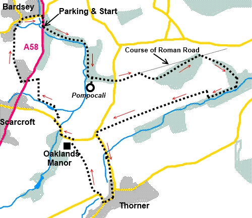
Start:
Leave the lay-by via the path at its rear into the woods (SE 369431). At a
‘T’ junction with the old railway line, turn right for about 50 yards
then take the path on the left.
The path opens out into a field and follows
the left hand side of the wood. At a hedge, keep straight ahead under the
power lines, ignoring the path to the right.
About 100 yards further on, turn right (SE
375428), following the right hand side of the field. Bardsey Beck soon
becomes visible amongst the trees on the right.
You enter Hetchell Wood Nature Reserve and
stay on the broad track straight ahead, soon passing Hetchell Crags on the
left. Ignore the path going uphill soon after the crags.
%20Hetchell%20Crag.jpg)
You meet a broad track by the bridge over the
beck. Turn left (SE 376423).
Stay on this track ignoring a bridle way off
to the right after a few yards. You soon come to a crossroads of
paths/tracks. Turn right through a gateway with a public bridleway sign to
look at the Pompocali earthworks
(SE 376423).
%20Pompocali%20Eathworks.jpg)
%20Massive%20wheatfield.jpg)
Return to the broad track and turn right. At
the road turn left very briefly then right to follow the public bridleway
sign to a ‘T’ junction at the end of the wood. Turn right here and after
only 20 yards or so, when the path forks, bear left following the public
bridleway sign (SE 392426).
The route from here can get a little
confusing because there are a few tracks without any indication as to where
they go so I describe a route where you can follow fingerposts. This may not
be the absolute shortest but it does not add greatly to the overall
distance.
At a two-way fingerpost showing a bridleway
in each direction, turn right (SE
498423). You will soon see Milner Beck on the left below you. At another
two-way fingerpost indicating bridleways, turn right to follow a left hand
field edge going slightly uphill (SE 393420).
At the top of the field, turn left and go
through a metal gate. Keep straight ahead ignoring a bridleway off to the
right. This is Kennels Lane. There is a footpath off this lane to Thorner at
SE 382417 but I must confess I missed this and continued to the road. There
is very little difference in distance (a two sides of a rectangle
situation).
At the road turn left (SE 377415) and left
again at the junction, passing an old milestone, and continue along Milner
Lane, into Thorner.
%20Old%20milestone.jpg)
%20St%20Peter's%20Church%20Thorner.jpg)
At the next road junction, turn right
signposted “Thorner ¼ mile” and “Leeds 9 miles”. Pass the parish
church.
Continue through the village and turn right
on Carr Lane (SE 378405), immediately before the Mexborough Arms. As the
road bends to the left, take the footpath on the right by the Thorner
Victory Hall following the public footpath fingerpost (SE 377406).
Go through a kissing gate and follow the
footpath alongside the hedge. Oaklands Manor sits on the hill to the left.
In the top left hand corner of a field, go
over a stile, and follow the walled path alongside the manor. When the
walled path ends at the private road, turn right then left at the public
road (SE 373414).
Stay on the road for about half
a mile, going round a sharp right hand bend. It starts to rise. Turn right
at the triangular island following the fingerpost (SE 371417). Pass the
white painted house on the corner then a stone house and turn left just next
to the garage on to the public footpath.
Follow the right hand side of the field and
take the footpath off to the right, about two thirds of the way along the
field over a footbridge over the beck into the trees.
The path quickly opens into another field.
Turn left to follow its left hand boundary. At the end of that field, go
over another stile and turn right following the right hand field boundary
(SE 368420).
%20View%20Near%20Bardsey%20towards%20Hetchell%20Wood.jpg)
At the end of this field, meet a broad track
which sweeps over to the right. Ignore this right turn and keep left,
walking parallel with the power lines.
At the main road (A58), go briefly left then
almost immediately right to follow the public bridleway sign.
This track is initially a private road to a
number of houses and at its end, continue on the narrow footpath straight
ahead.
At a junction where the main path looks to go
left, go right and follow the left hand edge of the field as it descends,
crosses a beck then goes into the churchyard. Turn right, around the right
hand side of the church and at the road turn right again. On reaching the
main A58, turn right back to the car.
%20Approaching%20Bardsey.jpg)
%20All%20Hallows%20Church,%20Bardsey.jpg)
If you need to buy any
hiking equipment/clothing before your trip see the Hiking
Store
All information on this
site is given in good faith and no liability is accepted in respect of any
damage, loss or injury which might result from acting on it.
|


.jpg)
.jpg)
.jpg)