
|
|
|
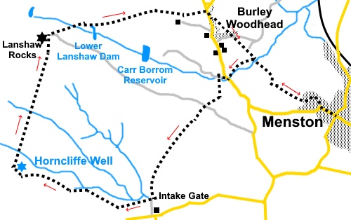
To view route as a dynamic Ordnance Survey map click here Introduction: This walk from Menston provides for some of the best views in the area, taking in both the Wharfe and Aire valleys. I have done this walk and variations of it several times and am always impressed by the views. To Otley Chevin, across the Wharfe valley to Beamsley Beacon and Almscliff (or Almscliffe) Crag and across the Aire valley, the Emley Moor transmitter mast is seen. At Horncliffe Well, on a clear day, even the North York Moors can be seen. Part of the walk is off public footpaths on Access Land but the route along a clear, grassy track is easy to follow. Note dogs are not allowed on this Access Land. Horncliffe Well was first mentioned in records in 1273. It was then a free flowing, “healing” well, which never dried, even after droughts and at one time simply opened on to the moor over an old stone. It was said to have healing powers and was no doubt a boon to those making their way across the moors. Unfortunately, after Yorkshire Water acquired it, the visible well disappeared beneath a manhole but the water can clearly be heard rushing and you can see the spring by lifting a nearby light plate. An old stone sign marks its position. Nearby, a stone stile includes an unusual boundary stone. This mentions one Thomas Pulleyn, who was at one time the Lord of the manor living at Burley Hall (Burley-in-Wharfedale). He died in 1759. The ruined building next to the well was evidently a small school, around the end of the 18th century. The walk returns via Burley Moor and Lanshaw Rocks, also known as Grub Stones, where there are some interesting rock carvings, though you have to search to find them. The walk starts at the cross roads in the centre of Menston, by the Menston Arms pub. To get there, turn off the A65 at the main traffic lights, between Guiseley and Otley, where signposted, on to Bingley Road. Follow this as it curves to become Menston Main Street. Follow this to the centre. Buses stop close to the train station and access to the centre is most easily described as turn right out of the station and follow Westbourne Drive, alongside the railway tracks to the ‘T’ junction with Burley Lane. Turn left to the centre. Parking is on street and fairly limited, due to residents cars. Start: From the cross roads (SE 168439), walk along Main Street, with the Menston Arms to your left. As the road turns sharply left, branch off right on to Bleach Mill Lane. Follow this lane, which is a mixture of tarmac and stony sections. It eventually enters the Bleach Mill House property and the public footpath becomes narrow, along the left hand side of the property. Continue, keeping a look out for a narrow slit stile on the right, alongside which is a post with a number of yellow footpath arrows. Turn left here, following the course of Carr Beck (SE 159445). You pass through an unusual three stone stile and an old mill dam on the left. The old mill chimney can be made out through the trees.
Follow the footpath, crossing Carr Beck via a footbridge and arriving at the steep lane Myrtle Lane. Turn right up this lane.
At the road cross with great care as the visibility is poor and continue up the track opposite (Green Lane). After less than a hundred yards, turn left, indicated by a yellow footpath arrow, crossing the stream (SE 155444). You enter what could be described as a “holly tunnel”.
Follow the tunnel to a kissing gate and once through it turn right
You join a broad track. Cross straight over through a slit stile, following a public footpath fingerpost (SE 153441). Take the obvious path to another slit stile and beyond this, follow the wall on the left.
As the path starts to descend, you will spot cars racing along the road to/from the Keighley direction but before you get to the road, you arrive at Intake Gate, a concrete water control construction, with a large sluice mechanism. This controls the flow of water to Reva Reservoir.
Immediately after this, turn right along the broad grassy track, crossing the Access Land referred to in the introduction (SE 148430). Follow this, avoiding any turns off as it meanders across the moor. On the horizon to the right, you should be able to make out the rectangular shape of a shooting hut which is where you will be heading after Horncliffe Well. The track meets another, running alongside a wall. Turn right and follow it to Horncliffe Well.
Cross the fence by the stile next to the well and turn right, following the path which initially runs alongside the fence (SE 132434). You cross some impressive low bridges across boggy ground installed by the Burley in Wharfedale Walkers Are Welcome group.
Follow the path all the way to the Lanshaw Rocks and shooting hut. If you look to the right around seventy five yards before the rocks, you may be able to make out the remains of a stone circle. This is marked on the 1:50000 OS map but not the 1:25000 for some reason.
Arrive at a broad track by the rocks (SE 136448). Depending on which path you used at the split a few yards before the rocks, either turn right briefly, then first left or the path may be straight ahead. The path descends, passing Lower Lanshaw Dam. When it divides, keep right, following a yellow footpath arrow.
Follow it down to the road then turn right and quickly left, down a concrete driveway, indicated by a fingerpost “Public Footpath to Menston” (SE 153450). Just before the house at the end of the drive, turn right through a kissing gate and follow the obvious path. Go through a gated slit stile and keep straight ahead, crossing a faint footpath at 90° to the path you are on. Go through two kissing gates, either side of a drive to Red Walls. Emerge into a field and follow the right hand boundary. to Hag Farm. Pass the farm buildings and keep straight ahead through a metal farm gate. Continue along the track and you will pass the slit stile and post with many footpath arrows, where you turned up by the stream on the outward journey. Retrace your steps along Bleach Mill Lane. If you need to buy any hiking equipment/clothing before your trip see the Hiking Store All information on this site is given in good faith and no liability is accepted in respect of any damage, loss or injury which might result from acting on it.
| | |||||||||||||||||

.jpg)
.jpg)
.jpg)
%20Old%20Mill%20sluice%20and%20Chimney.jpg)
%20Looking%20back%20down%20Myrtle%20Lane.jpg)
%20The%20holly%20tunnel.jpg)
%20Panorama%20across%20Wharfedale.jpg)
%20View%20over%20Airedale%20towards%20Emley%20Moor.jpg)
%20Telephoto%20shot%20of%20Emley%20Moor%20Transmitter.jpg)
%20Reva%20Reservoir.jpg)
%20Reva%20Reservoir%20intake%20gate.jpg)
%20Stone%20Marking%20Horncliffe%20Well.jpg)
%20Building%20Remains%20at%20Horncliffe%20Well.jpg)
%20Path%20to%20Lanshaw%20Rocks.jpg)
%20One%20of%20the%20bridges%20installed%20by%20Burley%20WAW.jpg)
%20Lanshaw%20Rocks.jpg)
%20One%20of%20the%20carvings%20at%20Lanshaw%20Rocks.jpg)
%20Lower%20Lanshaw%20Dam.jpg)
%20Local%20wildlife.jpg)