
|
|
|
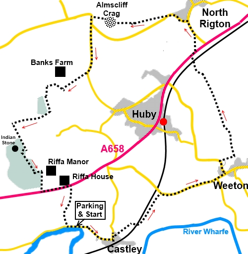
To view route as a dynamic Ordnance Survey map click here. Introduction: This walk to Almscliff Crag takes you in a circle from a parking area by the River Wharfe, through the villages of Weeton and North Rigton to the iconic crag, visible throughout much of the walk. There are pleasant river views towards Otley Chevin at the very start of the walk. Weeton has a prominent church of St Barnabas, competed in 1852, with a distinctive spire. Weeton is unusual in that it has a named railway station on the Leeds Harrogate line but it is in Huby. Quite why it is not Huby station is a mystery. North Rigton was plain Rigton until the 19th Century when ‘North’ was added to distinguish it from East Rigton, a few miles to the east. You can pause for refreshment at the Square and Compass inn! The village stocks are on display. The walk is not far from Harewood House where some Red Kites were released some years ago. These have thrived and you have a very good chance of seeing some, particularly in the Weeton area. Almscliff Crag is an outcrop of millstone grit and forms a prominent landmark visible from most of lower Wharfedale. It is very popular with rock climbers tackling some of its quirkily named routes such as Megadoom and Wall of Horrors. There are tremendous views from the top but you need to take care because being popular with climbers means there are long, vertical drops, especially on the north and west sides. The ‘trig point’ is unusual in that there isn’t one; or at least not the traditional pillar. Just a stud set in the rock. The return route passes Riffa Wood. If you want a brief diversion, you could visit the Indian Stone. This stone is (roughly) in the shape of an American Indian’s head. There is quite a story attached to this and more details can be seen in my Pool in Wharfedale to Leathley walk, which passes it. There is quite a bit of road walking but the roads are quiet, with the exception of the A658 which is just the opposite! Please take great care as it is fast and busy. The walk starts from some rough roadside parking by the river Wharfe, just west of the hamlet of Castley. To get there, assuming you are travelling from south of the river Wharfe, cross Pool Bridge and turn immediately right. The parking is on the right after a mile and a quarter. Start: From the car parking, with your back to the river, turn right along the road.
Walk through the hamlet of Castley and on the sharp, left hand bend as you leave it, turn right over a stile, following a public footpath fingerpost (SE 269459). There is a well defined, fenced footpath. Proceed to the arch and turn right under the railway. Immediately on leaving the arch, turn left and follow the course of the railway embankment. The route climbs a small, if steep hill, then crosses a stream. Beyond the stream, the ground rises more gently. At the top of the rise, join the road and turn right, following it to Weeton. As you do, on the horizon to the left, you can see the mass of Almscliff Crag.
In Weeton, turn left Weeton Lane following the road sign for Huby and Harrogate. As you are about to leave Weeton, immediately after Croft House, turn right following a public footpath sign (SE SE 284470). When the path opens into a field, follow the left hand boundary. On joining a broad track, over a robust stone stile (see photo), turn left following a yellow footpath arrow (SE 286 471).
Continue to follow the clear track, then the right hand field boundary initially, when it becomes less obvious. When the field boundary turns right at a right angle, keep straight on, bearing just slightly left, to cross a wooden bridge and stile. Once over the bridge, go through the five bar gate ahead and follow the obvious path. Cross a stile into a large field and turn right to follow the boundary heading towards a prominent stone house. There is a large fishing lake to the right. As you get to the end of the field, head for the left corner and over the stile into the trees. You are only in the trees for a few yards, before turning right in front of a house.
Follow the drive to the main A658 road. Cross it very carefully and turn right along the pavement for about a hundred yards. Turn left through a kissing gate, following a public footpath marker (SE 281486), then bear right at about 45°, until you get to the road. At the road, turn left (SE 281489). Arrive at North Rigton village. The route turns left along Crag Lane but if first you want to sample the delights of the Square and Compass Inn, continue along the road for a quarter of a mile or so.
Continue along Crag Lane, from which there are great views across the Wharfe Valley. On the outskirts of the village, look out for a bench, dedicated to one June Driffield, which makes for a good lunch stop, with a great view. Immediately before the bench, turn right over a stile following a yellow footpath arrow (SE 277491.
Go through a metal walkers’ gate and follow the path to Almscliff Crag which is clearly visible ahead.
It is worth a climb to the top of the crag, from which are fantastic views but there are steep drops at the opposite side so take care. The route continues through the “notch” in the middle of the crag over a rather awkward stile.
Curve gently right once beyond the “notch” then follow the path down to the road. Turn left along the road.
Stay on the road for just short of half a mile, ignoring a left turn. Look out for a right turn, indicated by a public bridleway sign, to Lower Banks Farm, opposite a copse of trees (SE 265483). As you get to the first house on the right, turn right to follow a public bridleway fingerpost. In the field beyond, roughly follow the right hand boundary ignoring a path off to the right, marked with a public bridleway arrow. The path curves anti-clockwise, passing under some power lines. On arrival at the wood, follow its boundary. At the end of the wood, go through a gate and turn right to follow the boundary wall downhill. At the bottom, turn right on the obvious path. On meeting a broad track, turn right towards the farm but shortly after crossing the cattle grid, turn right through a gate marked with a blue bridleway arrow. The path curves anti-clockwise round the farm. Beyond the farm, follow the left hand boundary of the field to the gate at the bottom and through this, turn left towards the wood, heading for its left hand corner. Go through the gate and turn right to follow the edge of the wood (SE 260477). You soon pass a gate into the woods. If you wanted a brief diversion into the woods to visit the Indian Stone, this is on the right after a couple of hundred yards. Otherwise, follow the edge of the woods to the corner of the field
Turn right into the woods and follow the track. On joining another track, turn left and at the gates to Riffa Manor, turn right down to the main A658 road. Turn left along the road for a quarter of a mile then, after passing Riffa House, cross the road and go down a broad track, indicated by a public footpath fingerpost (SE 263467). As the track swings right to the farm, go left through a gate and immediately right to follow the hedge. Follow the path downhill and through the farmyard at Ings Farm to the road. Briefly left takes you to the parking area. If you need to buy any hiking equipment/clothing before your trip see the Hiking Store All information on this site is given in good faith and no liability is accepted in respect of any damage, loss or injury which might result from acting on it.
| | |||||||||||||||||

.jpg)
.jpg)
.jpg)
%20Very%20full%20river%20Wharfe%20by%20parking%20area.jpg)
%20View%20to%20Otley%20Chevin.jpg)
%20St%20Barnabas%20Church%20Weeton.jpg)
%20Almscliff%20Crag.jpg)
%20Robust%20stile.jpg)
%20Fishing%20lake.jpg)
%20Village%20stocks%20North%20Rigton.jpg)
%20Looking%20South%20from%20the%20bench.jpg)
%20Approaching%20Almscliff%20Crag.jpg)
%20View%20through%20the%20notch.jpg)
%20View%20North%20from%20Almscliff%20Crag.jpg)
%20View%20south%20from%20Almscliff%20Crag.jpg)
%20View%20west%20from%20Almscliff%20Crag.jpg)
%20The%20trig.jpg)
%20Looking%20back%20at%20Almscliff%20Crag.jpg)
%20Indian%20stone.jpg)
%20Rainbow.jpg)